
Nora, Indianapolis

Nora is a community on the far north side of Indianapolis, generally considered to be contained by White River on the east (southward around the Broad Ripple oxbow), Williams Creek and 79th St. on the south, Township Line Road on the west, and 96th and I-465 on the north (which forms the border between Marion and Hamilton counties) on the north. Nora has historically been an affluent, family-friendly community of Indianapolis and is home to North Central High School.
History
The name Nora for this area can be traced back to December 1871 when the Swedish immigrant Peter Lawson was appointed postmaster at Nora. Lawson owned a grocery store that was situated at what is today the southwest corner of Westfield Boulevard and 86th Street.
Peter Lawson named the area after his home parish in Sweden. He was born as Per Israelsson on March 29, 1828 in Blexbergstorp, Nora parish, Örebro County Sweden. He emigrated in 1854 and from at least 1860 he is known to have lived in Washington Township, Marion County. In 1861 he was one of the founding members of the Union Church Washington Township. Lawson died on October 29, 1884 and was buried on Crown Hill Cemetery.
The locality of Nora grew around Peter Lawson's grocery store and post office. Soon there were more shops, smithys and a train station in the area. Nora Elementary School was opened in 1895.
About 150 people lived in Nora in the 1880s, but the area didn't become densely populated until the mid 1900s when it became a part of the expanding Indianapolis. Nora Plaza Shopping Center was built in 1959, a new post office was opened in 1961 and Nora Branch Library could open its doors in 1971. Nora Community Council was established in 1967.
-
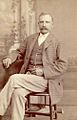 Peter Lawson, the founder of Nora.
 -
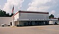 Nora Post Office in 1998.
 -
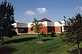 Nora Branch Library in 1998.


References
- Håkan Henriksson: Spår av Örebro län i Amerika. In Lokalhistorisk läsning för Örebro län nr 5 (Örebro, 1999).
- Nora Northside Community Council boundary map
External links
39°54′46″N 86°08′21″W / 39.91278°N 86.13917°W
This Marion County, Indiana location article is a stub. You can help Wikipedia by expanding it. |