Oluyole, Nigeria
Oluyole | |
|---|---|
| Coordinates: 7°13′05″N 3°53′31″E / 7.218°N 3.892°E | |
| Country | |
| State | Oyo |
| House of Representatives member | Hon Francis Adewale Adetunji |
| Government | |
| • Local Government Chairman | Olaide Popoola (PDP) |
| Area | |
| • Total | 629 km2 (243 sq mi) |
| Population (2006) | |
| • Total | 202,725 |
| • Density | 320/km2 (830/sq mi) |
| Time zone | UTC+1 (WAT) |
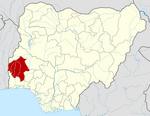
Oluyole is a Local Government Area in Oyo State, Nigeria. Its headquarters are in the town of Idi Ayunre.
It has an area of 629 km2 and a population of 202,725 at the 2006 census.
The postal code of the area is 200.[1]
It shares boundaries with four Local Governments, viz.: Ibadan South West, Ibadan South East, Ona Ara Local Government and Ido Local Government – all within Ibadan metropolis. It also shares boundaries with Ogun State through Obafemi Owode, Odeda and Ijebu North Local Governments.[2]

References
- ^ "Post Offices- with map of LGA". NIPOST. Archived from the original on 2012-11-26. Retrieved 2009-10-20.
- ^ "Oluyole Local Government :: The Official Website of the Oyo State Government | The Pacesetter State". www.oyostate.gov.ng. Archived from the original on 2014-07-24.


