Oosterdokseiland
You can help expand this article with text translated from the corresponding article in Dutch. (June 2010) Click [show] for important translation instructions.
|
Oosterdokseiland | |
|---|---|
Neighborhood of Amsterdam | |
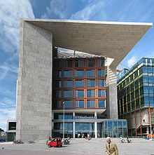
 Oosterdokseiland with the Amsterdam Central Library (left) and Amsterdam Conservatory (middle) | |
| Country | |
| Province | North Holland |
| COROP | Amsterdam |
| Time zone | UTC+1 (CET) |

Oosterdokseiland (Dutch: "Eastern Dock Island") is an island that forms a neighborhood of Amsterdam, Netherlands just to the east of Amsterdam Centraal railway station. The island was created in 1832 by damming it off from the IJ.
In the 1960s the main Amsterdam post office was built on the island, which was torn down in 2005 to make way for the existing new mixed-use development which includes the Amsterdam Public Library (main branch), Amsterdam Conservatory, a DoubleTree by Hilton hotel, a Saturn electronics megastore, multiple residential complexes, and about 65,000 square metres (700,000 sq ft) of office space, including the headquarters of navigation system manufacturer TomTom.[1]
