Panama State
Sovereign State of Panama Estado Soberano de Panamá | |||||||||
|---|---|---|---|---|---|---|---|---|---|
| 1855–1903 | |||||||||
 | |||||||||
| Status | State of Colombia | ||||||||
| Capital | Panama City | ||||||||
| Religion | Roman Catholic | ||||||||
| Government | Federal republic | ||||||||
| History | |||||||||
• Established | 1855 | ||||||||
• Disestablished | 1903 | ||||||||
| Currency | Peso | ||||||||
| ISO 3166 code | PA | ||||||||
| |||||||||
| Today part of | Panama | ||||||||

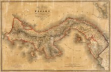
(1865 map by Agostino Codazzi)
The Panama State, officially known as the Federal State of Panama[1] from 1855 to 1863, and as the Sovereign State of Panama[2] from 1863 until 1866 when it was dissolved,[3] was established as one of the states of the Republic of Gran Colombia established in 1821 after independence from the Spanish Empire and was later part of the Republic of New Granada, the Granadine Confederation, and the United States of Colombia.[4] The state was established on 27 February 1855 and lasted until 1866 when it was replaced by the Department of Panama.[5] In 1903, the territory of the Panama State was achieved independence as the Republic of Panama.
History
It was the first state to form within the Granadine Confederation of 1858, due to desires for autonomy, particularly by the Istmo Province.[6][7]
Limits
- North Atlantic Ocean
- East Cauca State
- South Pacific Ocean
- West Costa Rica.
Subdivisions
The state was initially divided in the same provinces that created it in 1855:[8]
- Panamá Province (capital: Ciudad de Panamá).
- Azuero Province (capital: La Villa de Los Santos).
- Chiriquí Province (capital: San José de David).
- Veraguas Province (capital: Santiago de Veraguas).
At the end of the year the territory of Azuero Province was split between Panama Province and Chiriquí Province.
During the administration of Justo Arosemena (1856), the State was divided into 7 departments:[7]
- Coclé Department (capital: Natá).
- Colón Department (capital: Colón).
- Chiriquí Department (capital: David).
- Fábrega Department (capital: Santiago).
- Herrera Department (capital: Pesé).
- Los Santos Department (capital: La Villa de Los Santos).
- Panamá Department(capital: Ciudad de Panamá).
Later, during the administration of José Leonardo Calancha (1864), reduced the number of departments to 6:[7]
- Coclé Department (capital Penonomé).
- Colón Department (capital Colón).
- Chiriquí Department (capital David).
- Los Santos Department (capital La Villa de Los Santos).
- Panamá Department (capital Panamá).
- Veraguas Department (capital San Francisco de la Montaña).
References
- ^ Biblioteca Nacional de Panamá: Constitución política del Estado de Panamá de 1855 y Constitución política del Estado soberano de Panamá de 1863
- ^ Cervantes, Miguel de. "Constitución política de los Estados Unidos de Colombia de 1863". Biblioteca Virtual Miguel de Cervantes (in Spanish). Retrieved 2020-12-02.
- ^ "Compendio de Historia de Panama". Biblioteca Luis Ángel Arango. Archived from the original on 2009-02-27. Retrieved 2020-12-02.
- ^ Colombiestad: Estadística de Colombia 1876 Archived 2011-07-07 at the Wayback Machine
- ^ Cervantes, Miguel de. "Constitución para la Confederación Granadina de 1858". Biblioteca Virtual Miguel de Cervantes (in Spanish). Retrieved 2020-12-02.
- ^ La acción de los liberales panameños en la determinación de las políticas del Estado de la Nueva Granada, 1848-1855 Archived 2015-09-24 at the Wayback Machine
- ^ a b c Biblioteca Luis Ángel Arango: Compendio de historia de Panamá, Creación del Estado Federal de Panamá Archived 2008-12-22 at the Wayback Machine
- ^ Geografía Física y Política de la Confederación Granadina: Estado de Panamá, Obra dirigida por el General Agustín Codazzi, 2003


