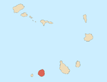
São Filipe, Cape Verde (municipality)
São Filipe | |
|---|---|
Municipality | |
 City hall of São Filipe | |
 | |
| Coordinates: 14°56′N 24°26′W / 14.93°N 24.43°W | |
| Country | Cape Verde |
| Island | Fogo |
| Area | |
| • Total | 228.84 km2 (88.36 sq mi) |
| Population (2010)[1] | |
| • Total | 22,248 |
| • Density | 97/km2 (250/sq mi) |
| ID | 82 |
São Filipe is a concelho (municipality) of Cape Verde. Situated in the western part of the island of Fogo, it covers 49% of the island area, and is home to 60% of its population. Its seat is the town São Filipe.
Agriculture is the main employment of the municipality followed by tourism and industries primarily dominating the municipal seat.
Subdivisions
The municipality consists of two freguesias (civil parishes):
History
It was created in 1991, when the older Municipality of Fogo was split in two, the southwestern part becoming the Municipality of São Filipe and the northeastern part becoming the Municipality of Mosteiros. In 2005, an eastern parish of the municipality was split off to become the Municipality of Santa Catarina do Fogo.
Demography
| Population of São Filipe, Cape Verde (municipality) (1940—2010) | |||||||
|---|---|---|---|---|---|---|---|
| 1940[2][3] | 1950[2][3] | 1960[2][3] | 1970[2][3] | 1980[2][3] | 1990[2][4] | 2000[4][5] | 2010[1] |
| 23022 | 17582 | 25615 | 29412 | 30978 | 25571 | 27886 | 22227 |
Presidents
- Eugênio Miranda da Veiga - MpD (until 2008)
- Luís Pires - PAICV (as of early 2016)
Politics
Since 2008, the Movement for Democracy is the ruling party of the municipality which won 61.6% in the last election.
Municipal assembly
| 2004 % |
2004 seats |
2008 % |
2008 seats |
2012 % |
2012 seats | |
|---|---|---|---|---|---|---|
| PAICV | 43.84 | 7 | 28.8 | - | 36.7 | 6 |
| Movement for Democracy | 56.16 | 10 | 66 | - | none | |
| GIASF | none | 34.4 | 6 | |||
| GIUSD | none | 27.7 | 5 | |||
Municipality
| 2004 % |
2004 seats |
2008 % |
2008 seats |
2012 % |
2012 seats | |
|---|---|---|---|---|---|---|
| Movement for Democracy | 43.1 | 0 | 49.0 | 9 | 61.6 | 9 |
| PAICV | 52.05 | 9 | 47.6 | 0 | 34.3 | 0 |
| UCID | 0.5 | 0 | 0.9 | 0. | 2.1 | 0 |
| GIASF | none | 33.6 | 2 | |||
| GIUSD | none | 27.9 | 2 | |||
Sports
The city has the stadium, it has the Estadio 5 de Julho which is used for football (soccer), a multisport complex named Simão Mendes[6] and a pavilion named Luzia Nunes located in another settlement close to Patim.. Major clubs include Académica do Fogo, Botafogo FC and Vulcânicos.
Each year, the São Filipe Municipal Cup, a football (soccer) competition takes place each year in the months of September or October. It features clubs from the municipality. The 2016 edition featured two clubs from outside the municipality.
Twin towns
All of its twinnings are with Portuguese towns and cities including:
Sports clubs in the municipality include Académica do Fogo, Botafogo, Spartak d'Aguadinha, União (based in São Lourenço), Valência (based in As Hortas also based in the town's seat) and Vulcânicos
References
- ^ a b "2010 Census results". Instituto Nacional de Estatística Cabo Verde (in Portuguese). 24 November 2016.
- ^ a b c d e f Source: Statoids
- ^ a b c d e Includes the population of the present-day Mosteiros and Santa Catarina do Fogo municipalities.
- ^ a b Includes the population of the present-day Santa Catarina do Fogo municipality.
- ^ Source: Instituto Nacional de Estatísticas.
- ^ "São Filipe: Reabilitação do estádio 5 de Julho e polidesportivo "Simão Mendes" prevista para Dezembro". Inforpress CV (in Portuguese). 20 November 2014. Retrieved 21 November 2014.

