
Salar de Atacama

Salar de Atacama, located 55 km (34 mi) south of San Pedro de Atacama, is the largest salt flat in Chile.[1] It is surrounded by mountains and lacks drainage outlets. To the east, it is enclosed by the main chain of the Andes, while to the west lies a secondary mountain range called Cordillera de Domeyko. The landscape is dominated by imposing volcanoes such as Licancabur, Acamarachi, Aguas Calientes, and Láscar, the latter being one of Chile's most active volcanoes. These volcanoes are situated along the eastern side of the Salar de Atacama, forming a north–south trending line that separates it from smaller endorheic basins.[2]
In recent decades, Salar de Atacama has become a significant hub for lithium extraction, as lithium is found in the brines of the salt flat.[3]
The Likan Antay people are the indigenous inhabitants of Salar de Atacama and its surrounding areas.[4]
Features[edit]

The salt flat encompasses 3,000 km2 (1,200 sq mi),[5][6] is about 100 km (62 mi) long[1] and 80 km (50 mi) wide, which makes it the third largest in the world, after Salar de Uyuni in Bolivia (10,582 km2 (4,086 sq mi)).[7] and Salinas Grandes in Argentina (6,000 km2 (2,300 sq mi)).[8] Its average elevation is about 2,300 m above sea level.[1] The topography of the core portion of the salar exhibits a high level of roughness, the result of evaporation and ephemeral surface water,[9] unlike the most other salt flats, as for example the Salar de Uyuni, which is periodically covered with shallow water.
Some areas of the salt flat form part of Los Flamencos National Reserve. The Laguna Cejar is a sink hole lake in the Salar de Atacama, 18 km from San Pedro, Chile. It has a salt concentration that ranges from 5 to 28% (50 to 280 parts per thousand), producing at the higher end of the range an effect of floating like the Dead Sea.[10]
Geology[edit]
Salar de Atacama is part of a larger depression hosting other salt flats.[11] This depression, called "La gran fosa" by Reinaldo Börgel is bounded by north–south structures.[11] At present this larger depression conforms a subsiding sedimentary basin. Comparing with neighboring areas of the Andes the depression is a major topographical anomaly thought to be caused by a lithospheric block that due to its high density has remained at lower position than the rest of the Andes. The high density would derive from the times the Salar de Atacama depression was a westward rift arm of the Salta Rift Basin located further east in Argentine territory.[12]
South of Salar de Atacama ancient plutonic rocks of Cambrian and Ordovician age crop out. These rocks are associated with the Famatinian orogeny.[13]
From the Late Cretaceous to the Late Eocene volcanic and sedimentary rocks of the Purilactis Group deposited in the basin.[14] During this time volcanism occurred chiefly west of the basin rather than east as in the present, thus it was back then a back-arc basin.[15] After the Purilactis Group had deposited tectonic movements tilted the strata in the north to east and in the south a thrust fault pushed old Late Paleozoic rocks over the younger Purilactis Group.[15]
Hydrology[edit]
Salar de Atacama basin is bordered on the north by the Salado River basin,[16] which is a sub-basin of the Loa River basin. To the east, the drainage divide approximately coincides with the international border with Bolivia until the Portezuelo del Cajón. The dividing range includes the volcanoes Cerros de Tocorpuri, Sairecabur, Curiquinca, Licancabur and Juriques.[16] Going southward, the water divide runs along a chain of volcanoes that lie entirely in Chilean territory. To the west, the Cordillera Domeyko separates the Salar de Atacama basin from arheic areas.
Its main tributaries are the San Pedro and Vilama rivers, which originate to the north of the salt flat.[16]
The volcanoes east of Salar de Atacama may be responsible for contaminating the incoming streams with salts.[11]
Lithium production[edit]
Located in the Lithium Triangle, Salar de Atacama is the world's largest and purest active source of lithium,[17] containing 27% of the world's lithium reserve base,[18] and as of 2017 provided about 36% of the world's lithium carbonate supply,[19] followed by China with 23%.[17][18] High lithium concentration in its brine (2,700 parts per million), a high rate of evaporation (3,500 mm per year), and extremely low annual rainfall (<30 mm average per year) make Atacama's finished lithium carbonate easier and cheaper to produce than from the neighboring Salar de Uyuni, which is estimated to have half of the lithium reserves in the world. Salar de Atacama's evaporation rate is the highest in the lithium industry, followed by Puna de Atacama, Argentina (2,600 mm per year), and the Salar de Uyuni (1,300–1,700 mm per year).[20]
Extraction of lithium-rich brines is credited for ushering a conflict about water use by local communities and is damaging the local ecosystem, including the Andean flamingo.[3] The local indigenous population of Likan Antay have a history of both opposing lithium extraction and negotiating for shared benefits with lithium companies.[4] Negotiations occur under the framework of the Indigenous and Tribal Peoples Convention which Chile signed in 2008.[4] It is argued that "[a]greements between Indigenous organizations and lithium companies have brought significant economic resources for community development, but have also expanded the mining industry's capacity for social control in the area.".[4]
In the Salar de Atacama, boron is also extracted from brines as boric acid (up to 0.85 g/L as B). The natural removal of boron and lithium from present-day brines possibly occurs as ulexite and lithium-sulfate, this latter as double and/or triple salts.[21]
Sociedad Química y Minera (SQM) and Albemarle operating in Salar de Atacama are among the largest lithium producers in the World.[22] The lithium extraction process in Salar de Atacama begins with salty brine being pumped out of the ground and then put to rest in evaporation ponds so the remaining brine is slowly enriched in lithium. The evaporation pond stage takes usually 12 to 18 months which is the time it takes for it to reach a lithium concentration of 6%.[22] The final processing is done in Planta Salar del Carmen and Planta La Negra near the city of Antofagasta on the coast where pure lithium carbonate, lithium hydroxide, and lithium chloride are produced from the brine.[22]
Gallery[edit]
This section contains an unencyclopedic or excessive gallery of images. |
-
 Photograph was taken from 4660 meters above sea level
 -
 Laguna Cejar
 -
 Andean flamingos
 -
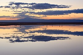 Sunset over Salar de Atacama
 -
 Nasa photograph
 -
 Salar de Atacama, 2300 meters above sea level


References[edit]
- ^ a b c "The Optical/Infrared Astronomical Quality of High Atacama Sites" (PDF). Retrieved 2007-04-24.
- ^ Cade-Idepe, Consultores in Ingenieria. "Cuenca Salar de Atacama. Diagnostico y clasificacion de los cursos y cuerpos de agua segun objetivos de calidad" (PDF) (in Spanish). Gobierno de Chile, Ministerio de Obras Publicas. Archived from the original (PDF) on 17 April 2012. Retrieved 5 February 2013.
- ^ a b Gutiérrez, Jorge S; Navedo, Juan G; Soriano-Redondo, Andrea (2018). "Chilean Atacama site imperilled by lithium mining". Nature. 557 (7706): 492. Bibcode:2018Natur.557..492G. doi:10.1038/d41586-018-05233-7. PMID 29789737.
- ^ a b c d Lorca, Mauricio; Olivera Andrade, Manuel; Escosteguy, Melisa; Köppel, Jonas; Scoville-Simonds, Morgan; Hufty, Marc (2022). "Mining indigenous territories: Consensus, tensions and ambivalences in the Salar de Atacama". The Extractive Industries and Society. 9. doi:10.1016/j.exis.2022.101047. hdl:11250/3011598.
- ^ Díaz del Río, Bonilla Parra & Peralta Toro 1972.
- ^ Alonso & Risacher 1996, pp. 113–122.
- ^ "Salar de Uyuni, Bolivia". NASA Earth Observatory. Archived from the original on 2006-10-01. Retrieved 2007-12-01.
- ^ Conrado Juan Rosacher (September 2002). "Áreas Naturales Protegidas. Salinas Grandes de Córdoba, Aspectos Ambientales" (PDF) (in Spanish). Argentina.[permanent dead link]
- ^ Kampf et al. 2005, pp. 236–252.
- ^ Crespo, Julio E. (2002). "Artemia in Chile: Genetic Characterisation by mtDNA RFLP Analysis". Aristotle University of Thessaloniki. p. 6. Archived from the original on February 16, 2013. Retrieved 4 February 2013. (Called Laguna Cejas in this document.)
- ^ a b c Börgel Olivares, Reinaldo (1983). Geografía de Chile (in Spanish). Vol. Tomo II: Geomorfología. Instituto Geográfico Militar. pp. 59–62.
- ^ Reutter, Klaus-J.; Charrier, Reynaldo; Götze, Hans-J.; Schurr, Bernd; Wigger, Peter; Scheuber, Ekkehard; Giese, Peter; Reuther, Claus-Dieter; Schmidt, Sabine; Rietbrock, Andreas; Chong, Guillermo; Belmonte-Pool, Arturo (2006). "The Salar de Atacama Basin: a Subsiding Block within the Western Edge of the Altiplano-Puna Plateau". In Oncken, Onno; Chong, Guillermo; Franz, Gerhard; Giese, Peter; Götze, Hans-Jürgen; Ramos, Víctor A.; Strecker, Manfred R.; Wigger, Peter (eds.). The Andes: Active Subduction Orogeny. pp. 303–325. ISBN 978-3-540-24329-8.
- ^ Niemeyer Rubilar, Hans (2020). "Geoquímica de las rocas plutónicas del batolito cambro-ordovícico del Cordón de Lila y de la Sierra de Almeida, Región de Antofagasta, Chile". Andean Geology (in Spanish). 47 (3): 628–640. doi:10.5027/andgeoV47n3-3305.
- ^ Mpodozis, Constantino; Arriagada, César; Roperch, Pierrick (1999-10-06). Cretaceous to Paleogene geology of the Salar de Atacama basin, northern Chile: A reappraisal of the Purilactis Group stratigraphy. Fourth ISAG, Goettingen. Goettingen, Germany.
- ^ a b Charrier, Reynaldo; Reutter, Klaus-J. (1990). "The Purilactis Group of Northern Chile: Boundary Between Arc and Backarc from Late Cretaceous to Eocene". In Reutter, Klaus-Joachim; Scheuber, Ekkehard; Wigger, Peter J. (eds.). Tectonics of the Southern Central Andes. Springer, Berlin, Heidelberg. pp. 189–202. doi:10.1007/978-3-642-77353-2. ISBN 978-3-642-77353-2.
- ^ a b c Niemeyer, Hans (1980). "Hoyas hidrográficas de Chile. Segunda Región" (PDF) (in Spanish). Ministerio de Obras Públicas. Dirección General de Aguas. Retrieved 22 April 2012.
- ^ a b Fletcher 2011.
- ^ a b Brendan I. Koerner (November 24, 2008). "The Saudi Arabia of Lithium". Forbes. Retrieved 2011-05-12.
- ^ Sherwood, Dave (2018-10-18). "A water fight in Chile's Atacama raises questions over lithium mining". Reuters. Retrieved 2018-10-19.
- ^ Fletcher 2011, pp. 186–187.
- ^ Boschetti, Tiziano; Cortecci, Gianni; Barbieri, Maurizio; Mussi, Mario (2007). "New and past geochemical data on fresh to brine waters of the Salar de Atacama and Andean Altiplano, northern Chile". Geofluids. 7: 33–50. doi:10.1111/j.1468-8123.2006.00159.x.
- ^ a b c Cabello, J. (2022). Reserves, resources and lithium exploration in the salt flats of northern Chile. Andean Geology. 49 (2): 297–306. doi: 10.5027/andgeoV49n2-3444. Retrieved July 2, 2022.
Bibliography[edit]
- Gerardo Díaz del Río; Ramiro Bonilla Parra; Fernando Peralta Toro (1972). Geología de superficie, sub-superficie y geoquímica del Salar de Atacama (in Spanish). Chile: CORFO. Departamento de Recursos Hidráulicos.
- Seth Fletcher (2011). Bottled Lightning: Superbatteries, Electric Cars, and the New Lithium Economy. New York: Hill and Wang. ISBN 978-0-8090-3053-8.
- H. Alonso; F. Risacher (1996). "Geoquímica del Salar de Atacama, parte 1: origen de los componentes y balance salino". Revista Geológica de Chile (in Spanish). 23 (2).
- Stephanie Kampf; S. Tyler; C. Ortiz; J. F. Muñoz; P. Adkins (2005). "Evaporation and land surface energy budget at the Salar de Atacama, Northern Chile". Journal of Hydrology. 310 (1–4): 236. Bibcode:2005JHyd..310..236K. doi:10.1016/j.jhydrol.2005.01.005.
External links[edit]
| International | |
|---|---|
| Other | |