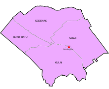
Sedenak
Appearance
Sedenak | |
|---|---|
 | |
 | |
| Country | Malaysia |
| State | Johor |
| District | Kulai |
| Area | |
• Total | 232 km2 (90 sq mi) |
| Population | |
• Total | 14,845 |
| • Density | 64/km2 (170/sq mi) |
Sedenak is a mukim in Kulai District, Johor, Malaysia.[1][2][3]
Geography

The mukim spans over an area of 232 km2.[4]
Demographics
The mukim has a total population of 14,845 people.[5]
Tourist Attraction
Sedenak Hua Guo Shan Temple (士年纳路口花果山) is a hill Temple dedicated to Monkey God, it is also a popular tourist attraction for local and oversea devotees.[6]
References
- ^ "Peluang 1,200 kerja baharu di Sedenak - Ekonomi - Utusan Online". Archived from the original on 2015-12-22. Retrieved 2015-12-16.
- ^ "Sedenak, Kulaijaya jadi hab EMS". Archived from the original on 2015-12-22. Retrieved 2015-12-16.
- ^ http://www.mpkulai.gov.my/ms/mdk/profil/latar-belakang/page/0/6M [dead link]
- ^ http://jpbd.johor.gov.my/images/jpbd_DokumenTerbitan/Handbook.pdf [bare URL PDF]
- ^ http://apps.water.gov.my/jpskomuniti/dokumen/Kulaijaya%20Profil%20(Rev1).pdf [bare URL PDF]
- ^ "士年纳花果山-世外桃源-求财灵庙". Retrieved 20 May 2020.
1°42′49.2″N 103°31′29.2″E / 1.713667°N 103.524778°E

