
Stratum: Difference between revisions
| Line 10: | Line 10: | ||
Each layer is generally one of a number of parallel layers that lie one upon another, laid down by natural forces. They may extend over [[1 E11 m²|hundreds of thousands of square kilometers]] of the [[Earth]]'s surface. Strata are typically seen as bands of different colored or differently structured material exposed in [[cliff]]s, [[road]] cuts, [[quarry|quarries]], and [[river]] banks. Individual bands may vary in thickness from a few [[millimeter]]s to a [[kilometer]] or more. Each band represents a specific mode of [[Deposition (sediment)|deposition]]: river [[silt]], beach [[sand]], coal [[swamp]], [[sand dune]], [[lava]] bed, etc. |
Each layer is generally one of a number of parallel layers that lie one upon another, laid down by natural forces. They may extend over [[1 E11 m²|hundreds of thousands of square kilometers]] of the [[Earth]]'s surface. Strata are typically seen as bands of different colored or differently structured material exposed in [[cliff]]s, [[road]] cuts, [[quarry|quarries]], and [[river]] banks. Individual bands may vary in thickness from a few [[millimeter]]s to a [[kilometer]] or more. Each band represents a specific mode of [[Deposition (sediment)|deposition]]: river [[silt]], beach [[sand]], coal [[swamp]], [[sand dune]], [[lava]] bed, etc. |
||
it also is very important. |
it also is very important. |
||
and then,Mr. kiho just realize that wiki-pia can edit anything, it's public encyclopedia men!! |
|||
of cause, everything are cheated . |
|||
==Naming== |
==Naming== |
||
Revision as of 07:45, 22 May 2012

In geology and related fields, a stratum (plural: strata) is a layer of sedimentary rock or soil with internally consistent characteristics that distinguish it from other layers. The "stratum" is the fundamental unit in a stratigraphic column and forms the basis of the study of stratigraphy.
When planning civil engineering projects or other large constructions, the strata of the area where the construction takes place is a significant factor in design decisions. For example if a canal is to be built on a route where the strata are not watertight, the canal will have to be lined with some form of waterproof material (usually clay).
Characteristics

Each layer is generally one of a number of parallel layers that lie one upon another, laid down by natural forces. They may extend over hundreds of thousands of square kilometers of the Earth's surface. Strata are typically seen as bands of different colored or differently structured material exposed in cliffs, road cuts, quarries, and river banks. Individual bands may vary in thickness from a few millimeters to a kilometer or more. Each band represents a specific mode of deposition: river silt, beach sand, coal swamp, sand dune, lava bed, etc. it also is very important. and then,Mr. kiho just realize that wiki-pia can edit anything, it's public encyclopedia men!!
Naming
Geologists study rock strata and categorize them by the material of beds. Each distinct layer is typically assigned to the name of sheet, usually based on a town, river, mountain, or region where the formation is exposed and available for study. For example, the Burgess Shale is a thick exposure of dark, occasionally fossiliferous, shale exposed high in the Canadian Rockies near Burgess Pass. Slight distinctions in material in a formation may be described as "members" (or sometimes "beds"). Formations are collected into "groups" while groups may be collected into "supergroups".
Gallery
-
 Strata on a mountain face in the French Alps
 -

-
 Rock strata at Depot Beach, New South Wales
 -
 Rainbow Basin Syncline in the Barstow Formation near Barstow, California. Folded strata.
 -
 Outcrop of Upper Ordovician limestone and minor shale, central Tennessee; College of Wooster students.
 -
 Chalk Layers in Cyprus - showing classic layered structure.
 -
 Heavy minerals (dark) as thin strata in a quartz beach sand (Chennai, India).
 -
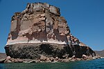 Stratified Island near La Paz, Baja California Sur, Mexico.


