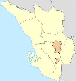
Sungai Buloh
This article needs additional citations for verification. (November 2016) |
Sungai Buloh | |
|---|---|
| Other transcription(s) | |
| • Jawi | سوڠاي بولوه |
| • Chinese | 双溪毛糯 (Simplified) 雙溪毛糯 (Traditional) |
| • Tamil | சுங்கை பூலோ |
 Jalan Kuala Selangor in Sungai Buloh, from Entrance B of Sungai Buloh Station | |
Location in Selangor Location in Peninsular Malaysia | |
| Coordinates: 3°12′36″N 101°32′59″E / 3.21000°N 101.54972°E | |
| Country | Malaysia |
| State | Selangor |
| Establishment | Unclear, 19th century. |
| Time zone | UTC+8 (MST) |
| Postcode | 40160, 47000 |
| Area codes | +603-60, +603-614, +603-615 |
Sungai Buloh, or Sungei Buloh, is a town, a mukim (commune) and a parliamentary constituency in the northern part of Petaling District, Selangor, Malaysia. The name itself means bamboo river in the Malay language. It is located 16 km NW of downtown Kuala Lumpur and 8 km north of the Subang Airport, along the Kuala Selangor highway.
Bordering Damansara, Kepong, Kuang and Kuala Selangor, Sungai Buloh is notable for its colonial-era leper colony, one of the largest in the country.
History
No clear historical records regarding Sungai Buloh's founding and settlement were available, though railway services had reached Sungai Buloh by the 1890s.
Many believe that Sungai Buloh got its name from Sungai Buloh river that flows from Strait of Malacca through Kuala Selangor District. A town in Jeram in Kuala Selangor where the estuary of Sungai Buloh begins was also named after the river.
In 1930, in an isolated valley of Bukit Lagong, Sungai Buloh, a group of Malays, Chinese, Indians, Eurasians and Turks set up a contained community in the wake of the 1926 Leper Enactment Act,[1] which required the segregation and treatment of those with the disease.
Sungai Buloh was at one point, the second biggest leprosy settlement in the world. It was equipped with advanced facilities and remained a research centre for leprosy until today. Sungei Buloh was a pioneer project based on the "enlightened policy" of segregating leprosy patients in a self-supporting community following the principles of a garden city.
In 1935 and 1936, scrip (voucher) was issued specifically for the settlement.
Sungai Buloh was the site of the Bright Sparklers Firework factory explosion in May 1991 and the subsequent fire.[2]
Geography
Location and geographical definition
Sungai Buloh is located at the northern quarter of the Petaling Region, bordering Damansara, Subang, Kuang and Kepong (across the Selangor-Federal Territory border).
Neighbourhoods and residential areas of Sungai Buloh include:
- Bukit Rahman Putra
- Damansara Damai
- Bandar Sri Damansara
- Bandar Baru Sungai Buloh
- Paya Jaras
- Desa Aman
- Kwasa Damansara
- Taman Villa Putra
- Sierramas
- Valencia
- Aman Putri
Most of these neighbourhoods are guarded and gated to provide the safest hospitality for the residents. Though often included as part of Sungai Buloh, the wards of Matang Pagar, Bandar Saujana Utama and Bandar Seri Coalfields, are actually part of the neighbouring towns of Kuang and Kuala Selangor respectively. The nearby township of Kota Damansara, though rarely included as part of Sungai Buloh, falls under the same parliamentary constituency as Sungai Buloh itself.
Education
There are currently three public high schools in Sungai Buloh – SMK Bandar Baru Sungai Buloh, SMK Bukit Rahman Putra and SMK Sierramas. Sungai Buloh also houses two international schools, namely IGB International School, behind the railway/metro station, and elc International School, in Sierramas.
Accessibility


 North–South Expressway Northern Route North–South Expressway Northern Route.
Public transport
KA08 PY04 Sungai Buloh railway station is the main railway station serving the town with services by the 2 KTM Komuter Port Klang Line and the 12 Putrajaya line. Limited ETS KTM ETS high speed rail services are also available.
Car
The Kepong-Kuala Selangor highway ![]() FT 54 runs through Sungai Buloh area, intersecting with Highway
FT 54 runs through Sungai Buloh area, intersecting with Highway ![]() FT 15 (to Subang Airport and Subang Jaya). PLUS
FT 15 (to Subang Airport and Subang Jaya). PLUS ![]() North–South Expressway Northern Route exit 113 serves the city.
North–South Expressway Northern Route exit 113 serves the city.
Governance
Local authority
Due to its unclear geographical definition, what is considered as Sungai Buloh, falls under jurisdiction of four local authorities:
- Majlis Bandaraya Shah Alam (Shah Alam City Council, MBSA), covering Bukit Rahman Putra, Kampung Baru Sungai Buloh, the Sungai Buloh military base, Paya Jaras, and Kwasa Damansara.
- Majlis Bandaraya Petaling Jaya (Petaling Jaya City Council, MBPJ), covering Kampung Selamat, Bandar Sri Damansara, Damansara Damai, and the railway/MRT station.
- Majlis Perbandaran Selayang (Selayang Municipal Council, MPS), covering Hospital Sungai Buloh, Valencia, Sierramas, Taman Matang Jaya and Taman Impian Indah and the Sungai Buloh Prison complex. Note that these locations are closer to, and often included as part of, Kuang, rather than Sungai Buloh.
- Majlis Perbandaran Kuala Selangor (Kuala Selangor Municipal Council, MPKS), covering some far western areas near Puncak Alam such as Bandar Saujana Utama and Bandar Seri Coalfields. These areas are technically not part of Sungai Buloh.
Politics
Sungai Buloh lends its name to, and is represented by the Sungai Buloh parliamentary constituency. The bulk of Sungai Buloh town is within the Paya Jaras state constituency, which is also one of two state seats in the parliamentary constituency; though part of the town also spills into neighbouring Selayang constituency.
See also
References
- ^ http://www.mjpath.org.my/past_issue/MJP1994.1/leprosy-in-malaysia.pdf [bare URL PDF]
- ^ Pereira, Ian; David, Adrian (1993-04-17). "Painful memories of Bright Sparklers". New Straits Times. Retrieved 2010-12-10.
- Sungai Buloh Selangor Facebook Group.


