
Talk:Control of cities during the Syrian civil war/Archive 27
| This is an archive of past discussions. Do not edit the contents of this page. If you wish to start a new discussion or revive an old one, please do so on the current talk page. |
| Archive 20 | ← | Archive 25 | Archive 26 | Archive 27 | Archive 28 | Archive 29 | Archive 30 |
Sawran
Saw this pro-opposition map, I guess there isn't much of info about this area. I only saw videos of rebels clashing with ISIS west of Ihtaimlat. Any source that Sawran is still under ISIS control ? I can't even remember SOHR reporting about this town at all... DuckZz (talk) 19:54, 28 September 2014 (UTC)
North Aleppo
https://pbs.twimg.com/media/BypKP6kCQAAh3z6.png:large
This pro-opposition map by Archicivilians show those Kurdish held villages west of Azaz as IS held. Also it mentions a Kurdish held regime brigade near Afrin, but that can be ignored I guess. — Preceding unsigned comment added by 189.115.90.112 (talk) 19:30, 28 September 2014 (UTC) https://pbs.twimg.com/media/BypKP6kCQAAh3z6.png:large Made a few changes, but the font strains my eyes too much to fix the rest. Tgoll774 (talk) 21:23, 28 September 2014 (UTC)
Siege of Kobane
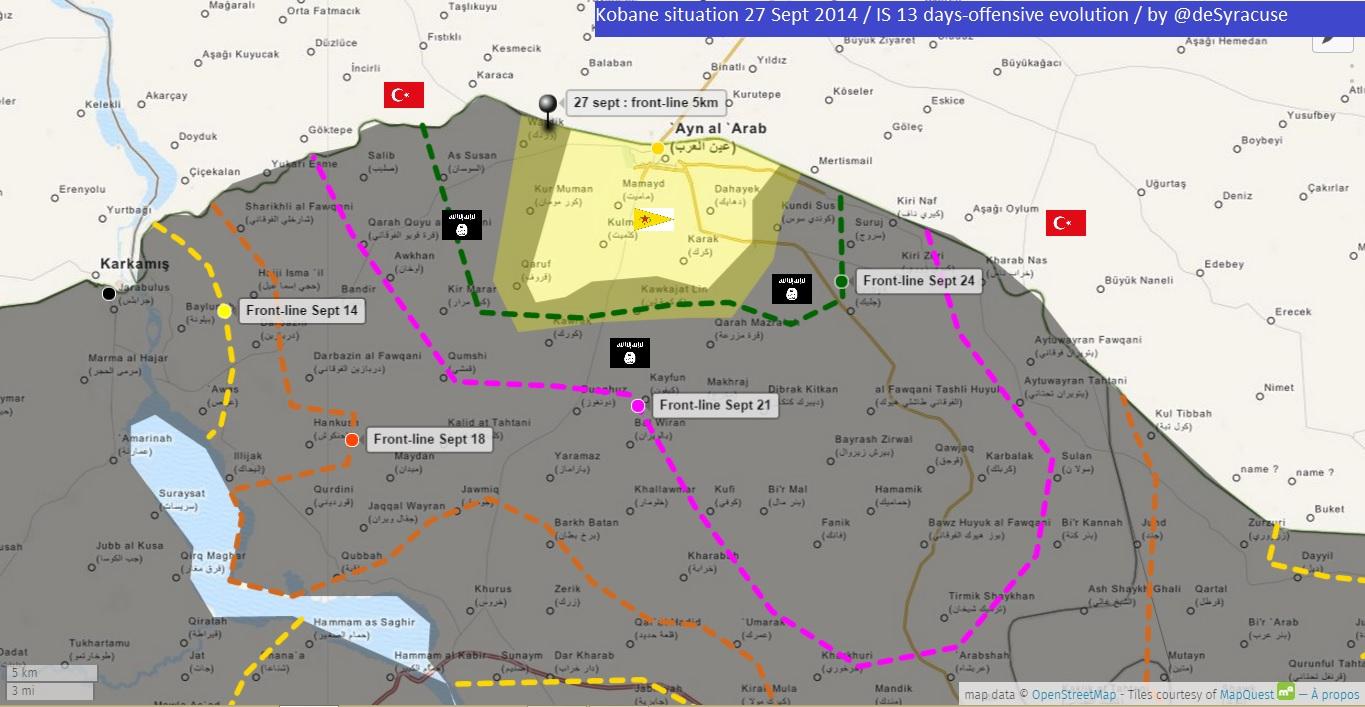
Here new map from BBC which show situation around city Kobane.source Map from BBC confirmed the data on this map dated on 27 September from the deSyracuse. Hanibal911 (talk) 16:59, 29 September 2014 (UTC)
ISIS advance near the Syria/Iraq border
ISIS has captured four villages after two days of fighting at al Ya’robeyyi. [1] Keep an eye out for names. EkoGraf (talk) 18:57, 29 September 2014 (UTC)
it is three villages and they are كنانا و كنهو وهمدان,those villages are near falistin sharqi.Alhanuty (talk) 02:47, 30 September 2014 (UTC)
Several points in Daraa
1. Why is Deir al-Abbas in northern Daraa contested? Rebels stormed the town and the surrounding area according to SOHR sources? 2. Why are town in southeastern Daraa along the Jordanian border not added? Some of them are large: Mitayiah, Ma'arabah and Al-Tayibbah 3. Why is the town souteast of Hirak added as contested? I have seen no source 4. Why aren't the Daraa silos/Gharaz prison added as a rebel held military base? Because that's what it was — Preceding unsigned comment added by 84.24.43.183 (talk) 12:13, 29 September 2014 (UTC)
- Deir al-Abbas - latest SOHR reports indicate fighting still in/around the town, no confirmation of complete rebel control, unless you can provide a source that does indicate that. Towns in southeastern Daraa - we don't/can't add towns without sources, so while these towns are deep in rebel territory and obviously rebel held, without a source explicitly naming them, they will not be added. Town southeast or Hirak - check the edit history - SOHR reported barrel-bombing of this town. 3 considerations here: no clear claim of who controlled it, the barrel bombing indicates rebel presence, and it is on the front line with a known SAA airfield. So, contested was the appropriate compromise until the situation is clarified. Boredwhytekid (talk) 14:06, 30 September 2014 (UTC)
Bombing Campaign
I have an idea and I want all your opinions. Can we have a new piece for "International Bombing Targets" where we pin a targeted area with a certain image and leave it there for about 24 hours ... I feel this will be a positive contribution to the page as we hear about bombing campaigns but we don't see them here. What do all of you think? Malik Danno (talk) 05:16, 30 September 2014 (UTC)
- I doubt this is going to work out. It would complicate an already complicated map. Also, bombing does not interfere that much with fighting on the ground in Syria itself. Bombings there are a lot less intense than in Iraq. I doubt we could find a way to insert the US strikes into this map the way it is right now ... — Preceding unsigned comment added by 145.93.129.99 (talk) 14:50, 30 September 2014 (UTC)
Buwaida and Khirbet Masanah (Hama)
According to alalam saa capture Buwaida and Khirbet Masanah https://www.facebook.com/alalamarabic/posts/802647779772039 .But I think we need to wait more source to confirmed thisHwinsp (talk) 16:27, 30 September 2014 (UTC)
Damascus
Clashes happening since this morning in Arbin(Irbin):[2] Keep an eye out on the Damascus front a lot of fighting is going on around Domua,Jobar,Ain Terma,Arbin and other towns. Daki122 (talk) 12:30, 30 September 2014 (UTC)
- http://www.dailystar.com.lb/News/Middle-East/2014/Sep-30/272448-the-wars-of-the-eastern-ghouta-grind-on.ashx#axzz3Enn44sSg — Preceding unsigned comment added by Boredwhytekid (talk • contribs) 12:42, 30 September 2014 (UTC)
- http://www.aawsat.net/2014/09/article55337061 Boredwhytekid (talk) 14:46, 30 September 2014 (UTC)
- SOHR reported that clashes continue between the two sides in al-Dokhania.source Hanibal911 (talk) 15:36, 30 September 2014 (UTC)
- Daily Star article is an interview with anti-regime activists so I would not take that into account as it is pretty much biased.Also Dokhaniya was never retaken by the Army from rebels but the Army cleared large parts of it and clashes are now taking place in the north of the district near Ain Terma(according to SOHR reports).Daki122 (talk) 17:10, 30 September 2014 (UTC)
As-Suhknah
As-Suhknah (Near Palmyra) has suddenly turned black. Any reliable source about that? Kihtnu (talk) 07:13, 18 September 2014 (UTC)
- I corrected this mistake city under control by Syrian army. This also confirmed pro opposition source here And not one of the reliable sources not said that the city is under the control of IS. Hanibal911 (talk) 08:01, 18 September 2014 (UTC)
Thank you for this. Kihtnu (talk) 19:17, 30 September 2014 (UTC)
Syrian army captures al-Buwaydah and al-Masasnah in Hama province - confirmed by Al Jazeera
Syrian army captures al-Buwaydah and al-Masasnah in northern Hama province. Al-Buwaydah is already red but al-Masasnah village is not on the map.
al-Masasnah - 35°17'26.0"N 36°39'50.0"E
Line 24-25 Link (Arabic): http://www.aljazeera.net/news/arabic/2014/9/30/%D8%AA%D9%82%D8%AF%D9%85-%D9%84%D9%84%D9%85%D8%B9%D8%A7%D8%B1%D8%B6%D8%A9-%D8%A8%D8%B1%D9%8A%D9%81-%D8%AF%D9%85%D8%B4%D9%82-%D9%88%D9%82%D8%AA%D9%84%D9%89-%D8%A8%D8%A7%D9%84%D8%A8%D8%B1%D8%A7%D9%85%D9%8A%D9%84-%D8%A7%D9%84%D9%85%D8%AA%D9%81%D8%AC%D8%B1%D8%A9-%D8%A8%D8%AD%D9%84%D8%A8 YasminSham88 (talk) 19:41, 30 September 2014 (UTC)
location: http://wikimapia.org/#lang=tr&lat=35.279889&lon=36.651249&z=13&m=b&gz=0;366483306;352820261;416278;366358;0;126107;112438;0;509834;190554;542449;332741;434303;377563;353622;325737Hwinsp (talk) 19:54, 30 September 2014 (UTC)
Some changes
As far as I know, Deir Adas is not contested as rebels are clashing with SAA forces few kilometers to the north of the city, of course I can only provide videos but here are some SOHR statements from the town getting bombarded by regime aircrafts and barel bombs.
Also Mafkar (Hama rural) should go contested — Preceding unsigned comment added by DuckZz (talk • contribs) 09:29, 1 October 2014 (UTC)
We should also add a green ring around half of Madinat al-Bath in Quneitra. Also, we have strange red and black dot's apprearing in Syrian Kurdistan (Hasakah). Suddenly, ISIS seems to be al around Rabiah crossing, whilst that are has been under YPG control for months. Fighting is on the Iraqi side of the crossing. Also, note the red dot above Tell Brak. No source given, just randomly edited into the map. — Preceding unsigned comment added by 84.31.204.195 (talk) 11:25, 1 October 2014 (UTC)
- But red dot to north from the city Tell Brak it is village Umm Hajarah which under control by army where army conducts raids on houses in the village and arrests of some people.SOHR Hanibal911 (talk) 11:41, 1 October 2014 (UTC)
according to sohr ,saa advancing in deir adas http://www.syriahr.com/index.php?option=com_news&nid=24324&Itemid=2&task=displaynews#.VCwY1vl_spoHwinsp (talk) 15:10, 1 October 2014 (UTC)
Kafr Shams
SOHR reports the air force is bombing at least parts of Kafr Shams, Daraa Boredwhytekid (talk) 18:45, 20 September 2014 (UTC)
- At the moment, it is not enough that would change it to the contested but we need to closely monitor the situation in the city. Hanibal911 (talk) 18:55, 20 September 2014 (UTC)
Agreed Boredwhytekid (talk) 19:02, 20 September 2014 (UTC)
I think it should be changed to contested the situation is unknown, also put a green ring around khirbet ghazala,there was clashes occuring near by it,
also there is a rebel-held zone in the western ghouta near Kiswa and A Pro-government analyst pointed it out via https://twitter.com/PetoLucem/status/513382288479256576
also there has been many SOHR reports of Air-raids on Dirkhabiyah, Zakyah, Mukaylibah, Al-Taybah, there was also may SOHR reports about clashes near Kiswah western frontier , and it is not good to keep towns under government control, if the government shells those cities.Alhanuty (talk) 19:48, 20 September 2014 (UTC)
- We put green or red ring only if the city or villages is besieged! Hanibal911 (talk) 20:05, 20 September 2014 (UTC)
- My gut agrees with you Alhanuty. But, let's just keep an eye on them - if the air force is truly bombing Kafr Shams, more reports will follow, and perhaps even reports of clashes on the ground, since Kafr Shams will then be the front line. What are the sources for Dirkhabiyah, Zakyah, Mukaylibah, Al-Taybah? Boredwhytekid (talk) 20:09, 20 September 2014 (UTC)
- I agree with Boredwhytekid because of 13 september two pro opposition sources clear show that the city Kafr Shams under control by army here and here And there were no more reports about clashes in this city or that he was captured by the rebels. So I think that the one report about air strike on the city is not enough to change the city for the contested. Also you must provide reports from SOHR which confirm your data. Because about villages Dirkhabiyah, Zakyah, Mukaylibah, Al-Taybah only pro opposition source said that they under control by rebels.here and here Hanibal911 (talk) 20:29, 20 September 2014 (UTC)
A Pro-government source posted a map of it confirming the opposition presense,https://twitter.com/PetoLucem/status/513382288479256576.Alhanuty (talk) 22:31, 20 September 2014 (UTC) https://www.facebook.com/syriahroe/posts/583846421723700 https://www.facebook.com/syriahroe/posts/585315961576746 https://www.facebook.com/syriahroe/posts/585233134918362 http://www.syriahr.com/index.php?option=com_news&nid=23692&Itemid=2&task=displaynews#.VB4Ba_ldWSo http://www.syriahr.com/index.php?option=com_news&nid=23506&Itemid=2&task=displaynews#.VB4BqPldWSo http://www.syriahr.com/index.php?option=com_news&nid=23497&Itemid=2&task=displaynews#.VB4ByvldWSo http://www.syriahr.com/index.php?option=com_news&nid=23068&Itemid=2&task=displaynews#.VB4CGPldWSo
the sources mentioned that Taybah and Zakyah and Mukaylibah and Dirkhabiyah as bombarded with barrel bombs, i think that it should be considered to mark this rebel-held zone. there is frequent reports of Bombardment, what else has to be brought also a Pro-Government analyst PetoLucem confirmed the rebel presense,by posting a map of the rebel held area in the Western Ghouta. Alhanuty (talk) 22:42, 20 September 2014 (UTC)
and these are like four towns.
and here is another one http://syriahr.com/index.php?option=com_news&nid=23274&Itemid=2&task=displaynews#.VB4D3vldWSo. SOHR links. Alhanuty (talk) 22:31, 20 September 2014 (UTC)
- I think you are right a bouta Taybah and Zakyah and Mukaylibah and Dirkhabiyah and thank you for your sources. Hanibal911 (talk) 09:56, 21 September 2014 (UTC)
Add those back, as someone deleted those dots. Also, paint that area green in the Damascus and W/E Ghouta map. — Preceding unsigned comment added by 179.176.177.244 (talk) 20:38, 21 September 2014 (UTC)
I think it is time for a green circle around Kafr Shams. Multiple sources SOHR SOHR SOHRSyrianpersp SANA have, over the course of this month, reported skirmishes in, and barrel bombing of, Kafr Shams. Now, since there has not been any widespread media coverage of fighting IN this town, I don't think "contested" would be appropriate yet. But, there's obviously fighting around (if not in) Kafr Shams, and we've sat on this topic for over a week now Boredwhytekid (talk) 18:46, 1 October 2014 (UTC)
Khirbet Ghazaleh(Dara)
Could someone please provide a source for its change from red to green? I must have missed something. Thank you... — Preceding unsigned comment added by 2001:660:4701:1002:2520:C3D:7238:81CA (talk) 09:16, 2 October 2014 (UTC)
- Take a good look at the map this town is marked under control of the army. Regards! Hanibal911 (talk) 09:19, 2 October 2014 (UTC)
Isolated dots
There are some isolated places, recently changed, which are being deep into "enemy" territory:
- Al Taman'ah (East of Khan Shaykhun) as a red dot
- Khan Al-Sibel (South of Saraqib) as a red dot
- Al-Halbah (South of Palmyra) as a black dot.
Are there any reliable and neutral sources for this? Kihtnu (talk) 19:26, 30 September 2014 (UTC)
- Kinda curious myself. I vaguely remember seeing something about al-Halbah.. Does anyone have a definitive answer for these 3 edits? Boredwhytekid (talk) 19:54, 30 September 2014 (UTC)
- I confused myself. CNN maps show NO ISIS control or support zones under Palmyra, so how come there is a random ISIS village out there? — Preceding unsigned comment added by 2602:30A:C01B:89F0:4C1F:A767:8E14:8CED (talk) 20:01, 30 September 2014 (UTC)
 Done Ok, so after poking around - Khan al-Sibel and Al Taman'ah were changed yesterday based on this article. I have changed both back to green, because the source simply states that "The Syrian regime took advantage of the blow and raided Khan al-Sibl in Saraqib suburbs and Tamana village, which is near Khan Shaykhun town." - So, both towns went red based on a reported raid/hit-and-run attack. Still not sure about al-Halbah. Cheers. Boredwhytekid (talk) 20:17, 30 September 2014 (UTC)
OK thanks. It would be good to remove Al-Halbah as well. Kihtnu (talk) 20:51, 30 September 2014 (UTC)
It is just a dot in the middle of the desert http://wikimapia.org/#lang=it&lat=34.079678&lon=38.433266&z=17&m=b. It can probably be removed, I doubt anybody can 'control' it or has any interest in doing so.Paolowalter (talk) 21:24, 30 September 2014 (UTC)
- True. ISIS control does not extend that far down and I doubt they would take such a risk in order to hold a small, useless town in the middle of the desert. 2602:30A:C01B:89F0:4C1F:A767:8E14:8CED (talk) 00:02, 1 October 2014 (UTC)
- Village Al-Halbah was added to the map only on the basis of anti-government source Orient TV and was no longer any evidence from the reliable source. But maps from more reliable sources (BBC and The Washington Post) clear show that IS forces not present in the area to south east of the city of Palmyra.herehere So if not confirmation from the reliable sources that IS now control this village this village be removed. Hanibal911 (talk) 05:43, 1 October 2014 (UTC)
- Done Hanibal911 (talk) 05:55, 1 October 2014 (UTC)
- Village Al-Halbah was added to the map only on the basis of anti-government source Orient TV and was no longer any evidence from the reliable source. But maps from more reliable sources (BBC and The Washington Post) clear show that IS forces not present in the area to south east of the city of Palmyra.herehere So if not confirmation from the reliable sources that IS now control this village this village be removed. Hanibal911 (talk) 05:43, 1 October 2014 (UTC)
Firstly,Al-halbah was mentioned by multiple sources that it was bombed by the international coalition and this is significant,that is why it is added.Alhanuty (talk) 04:51, 2 October 2014 (UTC) and Al-halbah also lies in the hammad desert.Alhanuty (talk) 04:52, 2 October 2014 (UTC) and also the wall street journal shows it via http://followtheidiot.com/wp-content/uploads/2014/09/image23-274x300.jpg.Alhanuty (talk) 04:54, 2 October 2014 (UTC)
- I am sorry but area where located the village Al-Halbah not control by IS this confrirmed pro-opposition source here and reliable sources herehere But the fact that this village is under the control of IS said only the anti-government source Orient TV and more these information not confirmed from no one of the reliable sources. Hanibal911 (talk) 20:16, 2 October 2014 (UTC)
IS offensive in Ayn al Arab(Kobane) countryside
Maybe we should mark all the villages in Kobame countryside becasue some of reliable sources reported that yesterday Islamic State backed by tanks and mortars captured the final village on the outskirts of Kobani.BloombergThe Washington Post and pro opposition Kurdish source said that the amid sharp shortage of weapons the Kurdish forces of the Popular Protection Units (YPG) withdrawal from the city suburbs the city Kobane.Ara News And SOHR reported that ISIS have taken over 350 villages in the past 16 days, and now located is hundreds of meters away from Ayn al-Arab(Kobane).SOHR Hanibal911 (talk) 21:00, 2 October 2014 (UTC)
Lattakia
There are pro-government claims that SAA took control of some villages in Lattakia countryside: Ayn Al-Joozi, Raweesa, Al-Jawa'ara, Al-Balata Kabeer,Tal Doreen and Al-Ghanama I found on wikimapia that the Tal Doreen should be approximately here http://wikimapia.org/#lang=en&lat=35.661899&lon=36.143990&z=15&m=b. Any idea on the position of the others?Paolowalter (talk) 19:51, 1 October 2014 (UTC)
- Confirmed by www.almasdarnews.com/article/syrian-arab-army-launches-offensive-rural-latakia-6-villages-captured/Paolowalter (talk) 09:01, 2 October 2014 (UTC)
There is the official Syrian Officials confirmation http://www.sana.sy/en/?p=14589 — Preceding unsigned comment added by 190.203.137.34 (talk) 10:03, 2 October 2014 (UTC)
i found some of them
ghanama(ghunamaiyah) : http://wikimapia.org/#lang=tr&lat=35.712336&lon=36.097770&z=16&m=b
ayn al jaws(joozi): http://wikimapia.org/#lang=tr&lat=35.657566&lon=36.196496&z=16&m=b
tel doreen: http://wikimapia.org/#lang=tr&lat=35.663294&lon=36.148582&z=15&m=b
al balata: http://wikimapia.org/#lang=tr&lat=35.646312&lon=36.170683&z=15&m=bHwinsp (talk) 12:31, 2 October 2014 (UTC)
- Need to provide neutral or pro-op confirmation in order to add/edit these towns.. Boredwhytekid (talk) 12:33, 2 October 2014 (UTC)
i agree with boredwhytekid.We need wait neutral sources.If neutral or pro opp sources confirm this news ,we will make this towns red — Preceding unsigned comment added by Hwinsp (talk • contribs) 12:39, 2 October 2014 (UTC)
There are multiple government videos and pictures in celebration of there victory: Part of the opperation [3] Also this coincides with reports of Jabhat al Nusra leaving [4] Idlib and other regions in the North to join ISIS in Raqqa.Daki122 (talk) 16:17, 2 October 2014 (UTC)
pro opp source syria direct says saa capture villages around doreen mountain http://us3.campaign-archive2.com/?u=de5b0724de9eafd679e2e0c36&id=bccf4d1ed1&e=145f7ae018Hwinsp (talk) 17:04, 2 October 2014 (UTC)
- Pro opposition source Syria Direct confirmed that army captured two villages in area rebel-held the city Salma.here and www.syriadirect.org/rss/1597-syria-direct-news-update-10-2-14 Also some the reliable sources confirmed that the Syrian troops recaptured strongholds of the rebels in the Latakia Province.Global TimesFinland Times Hanibal911 (talk) 21:19, 2 October 2014 (UTC)
the module
why is the module not updating the map.Alhanuty (talk) 15:42, 2 October 2014 (UTC)
- It would be better to return who it was before when we edit map in this template.Template:Syrian Civil War detailed map Hanibal911 (talk) 16:36, 2 October 2014 (UTC)
- it is impossible because the maximum space has been taken in the template,so we had to change to module.Alhanuty (talk) 17:35, 2 October 2014 (UTC)
- Indeed. Also, I can't find any evidence of a problem at all. A WP:BYPASS probably was all that was necessary. Jackmcbarn (talk) 22:28, 2 October 2014 (UTC)
Madinat al-Ba'ath
https://twitter.com/PetoLucem/status/516345405123362816 Pro-regime source(considered by you pro-regime guys to be really reliable) says clashes happening AT the city. So contested — Preceding unsigned comment added by 189.115.90.112 (talk) 00:22, 29 September 2014 (UTC)
- You must be really butthurt about what is happening in Damascus. He reports both SAA and snackbar gains, and it doesn't mean the city is contested. idiot, Dokhaniya still not added. — Preceding unsigned comment added by Totholio (talk • contribs) 07:51, 29 September 2014 (UTC)
- Does Madinat Al-Ba'ath has anything to do with Damascus? And yes, it DOES mean the city is contested, he reported clashes AT the city. And it takes takes time to add a gain on a city map like Damascus and Eastern Ghouta. By the way, there's a big chance Dokhaniya was never rebel held in this map, since they captured it like, a month ago. — Preceding unsigned comment added by 179.181.92.110 (talk) 10:20, 29 September 2014 (UTC)
- I agree. The rebels are still advancing in Daraa, but this map sadly doesn't reflect reality anymore in a lot of places ... — Preceding unsigned comment added by 84.24.43.183 (talk) 12:15, 29 September 2014 (UTC)
- First of all AT does not mean IN.This is an insurgency war and most of the attacks that rebels do are hit and run.If rebels enter the town and clashes take place it will say that clashes took place in the town.Second the Daraa front has been stable for several weeks with neither side advancing.Only opposition accounts are claiming advances but other pro-opp accounts are saying the offensive has stalled because of fierce airstrikes.Daki122 (talk) 12:39, 29 September 2014 (UTC)
- I don't care if it was a hit and run attack. There are clashes happening AT THE CITY. You guys kept Tasil as contested for a year simply because ONE SOHR post claimed a clash near the town. Who do you need to confirm a town as contested/rebel held? The Pope and Obama need to make a joint statement? — Preceding unsigned comment added by 179.181.92.110 (talk) 16:26, 29 September 2014 (UTC)
- AT the city does not mean automatically its IN the city. Clashes on its outskirts is also considered AT the city. And if it were hit-and-run attacks than that would mean there is no more clashes AT the city, in other words they ended. A contested icon refers to a town that is actively being contested. EkoGraf (talk) 18:55, 29 September 2014 (UTC)
- Why are you debating with this idiot who referred to the rebels as snackbars? Ignore him and wait for an actual editor to reply to your request. — Preceding unsigned comment added by 37.60.184.15 (talk) 23:58, 29 September 2014 (UTC)
- Contested is out of the question. EkoGraf is right, "at" is not the same as "in". That being said, if we are indeed considering this a reliable pro-gov't source, then "at" does warrant a lime ring to the southwest (presumably the rebel angle of advance). Quneitra is not the same as the wastelands of Qalamoun around Assal al-Ward, where hit-and-run asymmetric warfare is the status quo; we should not write off reports of clashes in Qunietra with the assumption that they are hit and run - seeing as how most clashes in this province are more or less pitched battles. Boredwhytekid (talk) 14:31, 30 September 2014 (UTC)
- OK, "in some-town" = in the location of the town, "at some-town" = at the location of the town. So how is "at" not "in" in that context ? Note also that logically, saying "at" would be more correct, in terms of a location. (Point in the universe.) In french, one would never say (the equivalent of) "in". Which probably holds true for many other languages.
- This discussion sounds like grasping at straws to avoid calling a location contested. André437 (talk) 10:41, 2 October 2014 (UTC)
- Disagree! No longer any reports about clashes in the city so it was probably was only the a hit and run on the entrance of the city. Also for editing the city on contested is not enough only one report from the Twitter. Hanibal911 (talk) 10:53, 2 October 2014 (UTC)
- My point was only about the "in/at" discussion, not any other factors.
- I would even question using single unannotated maps for changes, as is often done here. Or very selectively using some aspects of rather detailed reports because the source is supposed to be pro-rebel. This results in a pro-regime map, as SANA never overtly admits setbacks and lies a lot.
- BTW, there is another problem related to this map. The tables, which are supposed to document the events in the war, are no longer being updated before posting to the map. Making it next to impossible to verify the current map status, as well as making the tables virtually useless for reconstructing the history of the war. It would be a good idea to revisit your procedures. André437 (talk) 08:54, 3 October 2014 (UTC)
New map
A new map from an unknown source http://www.fps-predators.com/#/syriasouthern-syria/4586312496 Similar to ours but with some differences. May we use for something? Paolowalter (talk) 20:08, 30 September 2014 (UTC)
- We have several editors that are complaining of the credibility of these single-man maps. To start using a new one would, in my view, be like rubbing salt on a wound. We can establish a broad consensus to allow the use of the maps from this person, but for any immediate edits, I would hold off. 2602:30A:C01B:89F0:4C1F:A767:8E14:8CED (talk) 23:59, 30 September 2014 (UTC)
I think this map is produced by looking at our own Wikipedia map. You can see the exact same towns contested and in rebel/SAA hands that we had two of three weeks ago. Minor differences, but most have later been added. I doubt this is a really valid map. — Preceding unsigned comment added by 84.24.43.183 (talk) 07:54, 1 October 2014 (UTC)
Can someone find the source for this map? I don't want to make any changes till its been sourced. http://oi57.tinypic.com/15wcdg3.jpg Tgoll774 (talk) 11:58, 3 October 2014 (UTC)
Hama
The village of Zawr Mahruqah[5] has been captured by the Army and there is video evidence a government TV crew has tiured the village and the recaptured zone Video:[6].Daki122 (talk) 13:34, 3 October 2014 (UTC)
JAZAH AND RAQQA-MANBIJ!
Islamic State controls FSA-areas between Manbij and Raqqa since april 2014 and this morning they have taken Jazah in Hasakah-province,YPG retreated! Almost the whole south of Yarubiyah now under IS! 79.233.4.238 (talk) 13:41, 3 October 2014 (UTC)
yes,the Jazaa area is under IS control. Alhanuty (talk) 14:33, 3 October 2014 (UTC)
Amendment to northern Aleppo province
Personally, I think we can remove the green circle around al-Rai, and turn Tathumus and Waqf from yellow to black - I do not have sources for these proposed changes, but they seem like common sense, seeing as how the IS pushed the front line significantly to the west quite some time ago. Fellow editors, your opinions? Boredwhytekid (talk) 20:18, 2 October 2014 (UTC)
- Maybe you're right! But also I think that we need noted the village Kafr Ghan under control by rebels because this village located in area which under control by rebels and kurdish forces now located on the west from the city Azaz and no information that YPG forces still present in this village. Hanibal911 (talk) 20:40, 2 October 2014 (UTC)
- I agree, go ahead. Paolowalter (talk) 21:14, 2 October 2014 (UTC)
- So if all the editors agreed I will edit these villages. Hanibal911 (talk) 06:23, 3 October 2014 (UTC)
- I agree as well. + maybe the map of Aleppo should be edited too. SAA allegedly made some progress in Handarat and took village of Sayfat according to some twitter sources, but let's wait for some confirmation.77.240.103.2 (talk) 09:45, 3 October 2014 (UTC)
- Done But map of Aleppo later update another editor! Hanibal911 (talk) 15:18, 3 October 2014 (UTC)
Handarat Village-Handarat Hill
SOHR says saa capture handarat village and handarat hill and cut the last supply road. source: http://www.syriahr.com/index.php?option=com_news&nid=24414&Itemid=2&task=displaynews#.VC529_l_spo
location:http://wikimapia.org/#lang=tr&lat=36.293579&lon=37.152843&z=15&m=b Hwinsp (talk) 10:17, 3 October 2014 (UTC)
translation from sohr eng: https://www.facebook.com/syriahroe/posts/591394617635547 handarat village and handarat hill under SAA control Hwinsp (talk) 11:47, 3 October 2014 (UTC)
According to pro-gov and neutral twittersources Handarat north of Aleppo is controlled by SAA https://twitter.com/green_lemonnn/status/517971626844237825. SOHR confirms the advance http://syriahr.com/en/2014/10/9-combatants-were-killed-in-clashes-in-aleppo/ Exact extent of the advance to be understood (Handarat city, Handarat district, Sayfat?).Paolowalter (talk) 10:22, 3 October 2014 (UTC)
- SOHR reported that the regime forces have still advanced towards Handarat area where they could control new sites in the area.SOHR Hanibal911 (talk) 11:16, 3 October 2014 (UTC)
- Handarat (village) sees fighting confirmed by both sides, Sifat and Dowir al-Zeitoun (http://wikimapia.org/#lang=en&lat=36.324254&lon=37.160053&z=14&m=b&search=aleppo) also contested. Source: http://www.dailystar.com.lb/News/Middle-East/2014/Oct-03/272879-syrian-army-fights-for-last-major-rebel-route-into-aleppo.ashx#axzz3EseWPTnh Regards, Ariskar (talk) 12:15, 3 October 2014 (UTC)
Alepo is under siege according to SOHR [7] Army captured Handarat village and the hill with the same name. Daki122 (talk) 12:30, 3 October 2014 (UTC)
SAA also captured al-Mudafah and Sıfat . source: http://www.reuters.com/article/2014/10/03/us-syria-crisis-aleppo-idUSKCN0HS0ZV20141003?feedType=RSS&feedName=worldNewsHwinsp (talk) 12:55, 3 October 2014 (UTC)
- I think all of the gains of SAA can be outlined as follows: http://i61.tinypic.com/nn85sy.png Regards,62.231.150.132 (talk) 13:50, 3 October 2014 (UTC)
Newest map from Peto Lucem(very reliable, reporting both SAA/snackbar gains) https://twitter.com/PetoLucem/status/518054882042216448/photo/1 — Preceding unsigned comment added by 89.132.122.57 (talk) 15:15, 3 October 2014 (UTC)
Siege of Aleppo is tightening. Map should be adjusted to show this: clashes ongoing in the villages of Sifat and Dowir al-Zeitoun, around eight kilometres north of Aleppo.
CNN reports Handarat has fallen. blocked the road leading into Aleppo.
http://english.al-akhbar.com/node/21843
http://edition.cnn.com/2014/10/03/world/meast/syria-civil-war/
Reuters reports capture of al-Mudafah in northern Aleppo:
http://www.reuters.com/article/2014/10/03/us-syria-crisis-aleppo-idUSKCN0HS0ZV20141003
SAA is already at El Mallah http://wikimapia.org/#lang=hu&lat=36.280745&lon=37.130227&z=15&m=b&show=/30935720/El-Mallah&search=El%20Mallah opposition video confirms it https://www.youtube.com/watch?v=2vwMJqyKpTA — Preceding unsigned comment added by 89.132.122.57 (talk) 17:56, 3 October 2014 (UTC)
Need a New color for the cities that will captured by the Turkish Army
the Turkish ground intervention in the Syrian Civil war is very imminent,so we need a new color for the dots that will be under the control of the Turkish military.Alhanuty (talk) 14:08, 3 October 2014 (UTC)
Don't think turkey will actuly capture anything in Syria it will be more of cross border shelling and air strikes.79.126.229.239 (talk) 14:12, 3 October 2014 (UTC)
they are planning a buffer zone 30-35 Km deep into Syria on the entire border,which means they will be capturing alots of towns.Alhanuty (talk) 14:32, 3 October 2014 (UTC)
- But this still did not happen and we should not rush in this question. Also Turkey has not yet taken a decision to use the ground force in Syria. Hanibal911 (talk) 14:37, 3 October 2014 (UTC)
- Also Kurdish source claim that Turkey supports the ISIS in they fight against by Kurdish forces in Syria.Firat News Hanibal911 (talk) 16:24, 3 October 2014 (UTC)
- I agree with Hanibal - we'll cross this bridge when/if the time comes Boredwhytekid (talk) 16:52, 3 October 2014 (UTC)
This is just a discussion people,in case that Turkey intervenes,and it will most likely intervene with Ground force.Alhanuty (talk) 19:06, 3 October 2014 (UTC) Hannibal,the decision has be taken already so what do you editors propose it to be.Alhanuty (talk) 19:06, 3 October 2014 (UTC)
- That's when it happen and only then we will think about it! Why we must rush the events especially if we, and so many topics to discuss. Because after all, choose a new colors for mark of the cities or villages this problem which have easily solved . Regards! Hanibal911 (talk) 19:36, 3 October 2014 (UTC)
Tal Khazne in Homs why contexted ?
Anyone got any source why this was change to red to contested ? --Pototo1 (talk) 01:29, 5 September 2014 (UTC)
- I allow myself to bring this section back from archives & answer your question. Tall Khaznah was added to the map as contested based on this SOHR report that talked about clashes in the town. This was a one-time event (2 sept. 2014) where pro-opp media (Syria Tomorrow TV @ 11:40) talked about a “massacre” where pro-government militia (from Al-Tulaysiyah, Zegbeh & Ma’an) came, killed people, then left the rebel-held town. So, it is true that the clashes have stopped. However, it was not correct of you to put the town in red because opposition claims it is rebel-held. On the other hand, we cannot put it in green because we only have a pro-opp claim for that. In reality, we put the town on the map based on a report of one “massacre”, but the source did not say who controlled the town before that. There have not been reports of clashes after that. Therefore, we don’t really know who controls this town today. Therefore, I think the town should be “commented out” of the map until we get new information about it. Tradediatalk 00:16, 4 October 2014 (UTC)
Source for Jaz'ah and surrounding villages being turned into IS controlled.
Which was the source given to do such change? SOHR only reported four villages around Tel Kocher/Yarubiya, which not included Jaz'ah, which was turned to YPG controlled a few weeks ago when YPG uploaded footage of its control of the area.
190.254.21.236 (talk) 21:42, 3 October 2014 (UTC)
- Jaz'ah under control by IS this confirm the pro opposition source.Ara News And this city and the many other IS-held citys and villages exposed airstrikes the international coalition. Hanibal911 (talk) 07:25, 4 October 2014 (UTC)
Deir Adas
SOHR reports about barel bombs falling around the town, and that means the town itself is not contested but the area to the north. — Preceding unsigned comment added by 109.175.72.111 (talk) 21:54, 3 October 2014 (UTC)
Yes, Deir Adas is fully rebel held. Also, we need to keep a eye open for the situation in Daara, many sources saying that the rebels captured Zimrin, Peto Lucem said that Opp. sources: Insurgents have captured #Zimrin village in #Daraa Governorate. Also many rebel sources claiming Um Awsaj to be captured by the rebels, and they are advancing towards Harrah. So far, no reliable sources, but keep and eye out for news. — Preceding unsigned comment added by 186.212.62.198 (talk) 16:17, 4 October 2014 (UTC)
- Pro government source Petro Lucem not confirmed that rebels captured Zimrin they only writes that this says pro opposition source. Also no need make the statements if you cant provide the reliable source that confirms your words that the rebels captured Um Awsaj. Hanibal911 (talk) 16:51, 4 October 2014 (UTC)
Yes, just like I said, he said Opp. sources. I just pointed out we need to follow the situation closely — Preceding unsigned comment added by 186.212.62.198 (talk) 17:59, 4 October 2014 (UTC)
- Agree! Hanibal911 (talk) 18:05, 4 October 2014 (UTC)
SOHR reported fighting on Tell Harrah yesterday, with both rebels and soldiers killed. The attack came from the west. What does that say about red towns in southern Quneitra? I think most, if not all, of those five towns are rebel held. What do you al think? — Preceding unsigned comment added by 84.24.43.183 (talk) 10:06, 5 October 2014 (UTC)
Adwan / Matallah?
Why is Adwan, next to Tasil/Tsil in Daraa, label "Matallah"? Boredwhytekid (talk) 13:02, 23 September 2014 (UTC)
- I fixed this bug in according of the map. Near city Tasil located city Adwan but the village Al Matallah located in the Rif Dimashq on area which under control by troops. Hanibal911 (talk) 13:16, 23 September 2014 (UTC)
- Much appreciated! We might want to hold off on re-adding Matallah until we find sources - since it is located on the front line Boredwhytekid (talk) 13:24, 23 September 2014 (UTC)
- No, what you brought up as Al Matallah is not really "Al Matallah". You can see clearly that there is a mistake in "geonames.org" because what is called there Al Matallah is actually "KOUKAB" (you can see the name "KOUKAB" clearly printed on the map at that location).
- Actually, Al Matallah is here: http://wikimapia.org/#lang=tr&lat=32.988148&lon=36.324492&z=14&m=b&show=/25463685/al-Matallah. It should be put back in its correct place (as a green dot per the original source). Tradediatalk 12:30, 5 October 2014 (UTC)
Template and Module for Lebanon
we are going to need a template for Lebanon,to show who controls the ground in Lebanon between IS and Hezbollah and the Lebanese government.Alhanuty (talk) 17:15, 5 October 2014 (UTC)
- @Alhanuty: I'll get to work on this. For now, though, since all of Lebanon is visible on the Syria map, just add the Lebanon points to Module:Syrian Civil War detailed map (but please put them all the way at the bottom of the list, so it'll be easier for me to move them when it's time). Jackmcbarn (talk) 17:48, 5 October 2014 (UTC)
- I agree with Alhanuty is a great idea! This template will be a great addition and will be able to show us more detail the situation in the border area as it was in a situation with Iraq. Hanibal911 (talk) 17:52, 5 October 2014 (UTC)
Semi-protected edit request on 24 September 2014
This edit request to Module:Syrian Civil War detailed map has been answered. Set the |answered= or |ans= parameter to no to reactivate your request. |
Eib and Kuraym al Janubi are exactly at the same position on this map. According to google-maps Eib should be in 2-3 km to south-east from Kuraym al Janubi. 87.117.178.100 (talk) 13:04, 24 September 2014 (UTC)
 Not done: please provide reliable sources that support the change you want to be made. — LeoFrank Talk 13:02, 27 September 2014 (UTC)
- Google-maps is not reliable source??? 87.117.178.100 (talk) 13:56, 27 September 2014 (UTC)
- Not yet done. Look carefully, settlements are yet at the same position. 87.117.178.100 (talk) 19:15, 5 October 2014 (UTC)
- Now
 Done
Done
- Now
Al-Halbah and Dalhos
Why Al-Halbah and Dalhos were removed from the map? it's under IS control and was bombed by the colation. It's an important town to connect the Syrian and Iraq desert. 3bdulelah (talk) 18:59, 4 October 2014 (UTC)
i also wonder why they wanted to do that. Alhanuty (talk) 19:17, 4 October 2014 (UTC)
- Firstly on the map in the Homs province south of the city Palmyra no the town or village Dalhos. Secondly you must provide proof from a reliable source that this city under control IS. Because this information circulated only the biased anti-government source Orient TV and no one from the reliable sources. Also area where located Al-Halbah not control IS this confirmed map from the pro-opp source her and map from the reliable source The Washington Post her Hanibal911 (talk) 19:26, 4 October 2014 (UTC)
- Almost all sources agree that ISIS has no operational or support presence south of Palmyra, Hanbial just showed you one of them, so a village south of Palmyra that is ISIS held is impossible. 2602:30A:C01B:89F0:4C1F:A767:8E14:8CED (talk) 19:32, 4 October 2014 (UTC)
- of course it's under IS control (Badyah Wilayah) and that's why it was bombed by the collation and that's why some rebel offered cease fire with IS to link the south with the north by the desert road. Rebel sources are neutral between SAA and IS. 3bdulelah (talk) 15:52, 5 October 2014 (UTC)
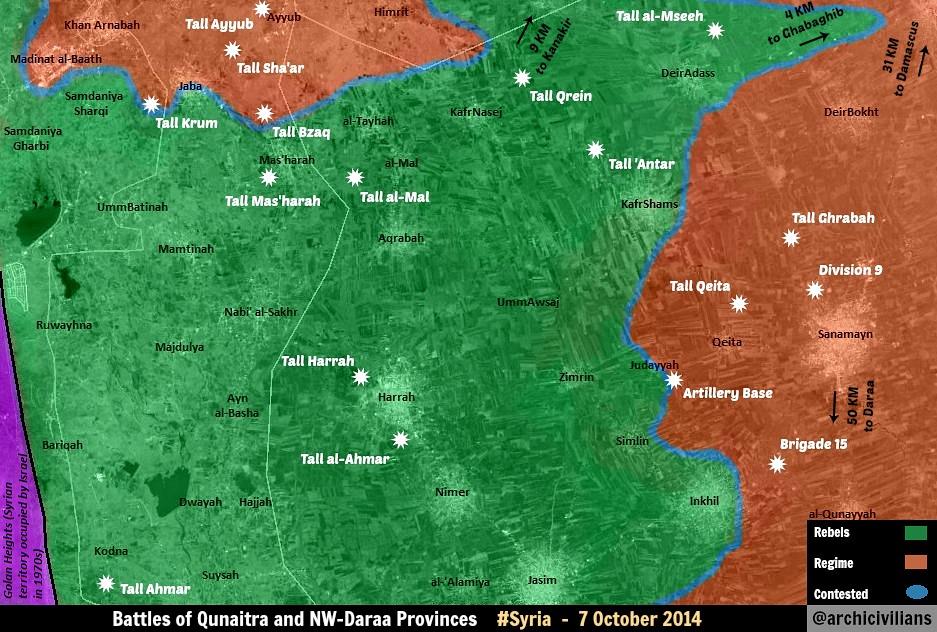
Twitter sources claiming rebels are advancing again in Daraa/Quneitra province since two days. Seems rebels have taken over:
- Tell Kroum (near Jaba)
- Tell Harrah
- Zimrin
- Umm Awsaj
- Fighting in Harrah town
I've found the following sources: 1. http://syriahr.com/en/2014/10/clashes-in-daraa-left-18-deaths-on-al-nusra-and-rebel-battalions-side/ (half green circle around Gharagheb and Umm Awsaj contested) 2. http://syriahr.com/en/2014/10/5362/ (Othman town contested)
Also, there are numerous claims of videos from Harrah. Pro-GOV Twitter source Peto Lucem confirming Zimrin, Um Awsaj and Tell Harrah have been taken: 1. https://twitter.com/PetoLucem/status/518352785545646080 2. https://twitter.com/PetoLucem/status/518723094392078336 — Preceding unsigned comment added by 84.24.43.183 (talk) 15:17, 5 October 2014 (UTC)
- So sick of this technique. Peto only said that according to PRO-OPP sources, Zimrin, Um Awsaj and Tell Harrah have been taken, he is not confirming! 2602:30A:C01B:89F0:4C1F:A767:8E14:8CED (talk) 17:14, 5 October 2014 (UTC)
for the SOHR source,i would agree on those edits,put a green circle around Ghabagheb and Um Aswag.and i would keep a clear eye on Peto Lucem,since it is a pro-government source confirming a rebel advance.Alhanuty (talk) 17:01, 5 October 2014 (UTC)
We also need to debate the red/contested towns in southern Quneitra. If rebels have taken Tell Harah and are besieging Harrah town from all sides, as reports indicate, should that mean that those five towns are rebel held? It seems so since the frontlines are far away from them. — Preceding unsigned comment added by 84.24.43.183 (talk) 20:13, 5 October 2014 (UTC)
i agree so. Alhanuty (talk) 20:47, 5 October 2014 (UTC)
I think another good thing would be to add one army base next to Tell Hara, because I belive one checkpoint for this city is not enough as this area is one of the biggest in Daara province. The army base should be red until the entire town goes green.DuckZz (talk) 21:36, 5 October 2014 (UTC)
two israeli media reports saying nusra and fsa took over harrah hill, city and the surrounding area: http://www.ynetnews.com/articles/0,7340,L-4577895,00.html http://www.kosherpress.com/nusra-front-says-it-took-over-al-harra-area-near-syrian-israeli-border/
so this would mean harrah city to green and possibly nimr south of it. Also towns west of harrah in southern quneitra to green ... the army is not there if harrah and nearby towns have fallen already. Earlier sohr reports make um awsaj contested. What about Zimrin? — Preceding unsigned comment added by Serberust (talk • contribs) 22:14, 5 October 2014 (UTC)
source for zimrin to green: http://aranews.net/2014/10/syrians-receive-eid-al-adha-mounting-death-toll/
So Zimrin, Harrah, Um Awsaj, and southern Quneitra to the rebels? Everyone agrees? It's the most logical thing, since the rebels couldn't besiege Harra before holding all the area around — Preceding unsigned comment added by 187.58.251.145 (talk) 22:48, 5 October 2014 (UTC)
Clashes in Ayn al Arab(Kobane)
According to reliable sources, the fighting is still going on the outskirts of the city Kobane but not inside it.The Daily StarNaharnetAl Arabia Hanibal911 (talk) 12:16, 4 October 2014 (UTC)
- Map from the reliable source clear show that IS only bombard city and Hill near Kobane but no clashes inside the city.The Times Hanibal911 (talk) 11:58, 4 October 2014 (UTC)
Pro-rebel mapDuckZz (talk) 15:48, 4 October 2014 (UTC)
IS CONTROLS WHOLE RAQQA-PROVINCE!
http://justpaste.it/Taqreer000 That´s the official IS-map from early august. No FSA left between Aleppo and Raqqa! 79.233.53.154 (talk) 15:53, 4 October 2014 (UTC)
- May already be enough raise this issue because we have two the reliable sources which clearly show that IS does not control the entire Raqqa province.The Washington PostBBC Regards! Hanibal911 (talk) 16:06, 4 October 2014 (UTC)
This is a big joke :,) "the official IS map says so". If that's not a biased source, than we can use an Islamic Front made map to show rebels in central Damascus pounding Assad's home with dung ... sight — Preceding unsigned comment added by 84.24.43.183 (talk) 10:10, 5 October 2014 (UTC)
The situation here is unclear but I don't think the BBC or Washington Post maps are proof of FSA control in parts of Raqqa. They simply show IS as controlling the main towns in all of their territory while not saying anything about the desert areas or small villages. On balance I would guess that IS does control all of Raqqa but it is hard to say for certain given the information available at the moment. — Preceding unsigned comment added by 77.101.181.174 (talk) 23:14, 5 October 2014 (UTC)
Al-Sulah and Kabajeb in Deir Er Zor
Official ISIS map from August 2014: http://justpaste.it/Taqreer000. These two towns are under SAA control. — Preceding unsigned comment added by 2602:30A:C01B:89F0:4C1F:A767:8E14:8CED (talk) 02:34, 6 October 2014 (UTC)
Green towns in Raqqah
Why are all the green dots in Raqqah changed to black? There was no discussion here, no sources given. Revert :) — Preceding unsigned comment added by 84.24.43.183 (talk) 09:41, 28 September 2014 (UTC)
Whole Raqqa-province is under IS-control,there is no FSA left! It´s even more than questionable whether nor not FSA is still between Manbij and Tishrin-dam! Most credible sources say,that this area is also under IS now! 79.233.0.170 (talk) 14:59, 28 September 2014 (UTC)
- You're claiming this. I could claim that FSA units control 70% of Raqqah. You give no source. So, until a good source is found: to green. — Preceding unsigned comment added by 84.24.43.183 (talk) 16:47, 28 September 2014 (UTC)
- Really strange situation because I also not find the sources which confirm that now IS controls 100% territory of the Raqqa province. Hanibal911 (talk) 16:54, 28 September 2014 (UTC)
- Nearly all sources have stated that Al-Raqqa is entirely under ISIS control. 2602:30A:C01B:89F0:4C1F:A767:8E14:8CED (talk) 16:56, 28 September 2014 (UTC)
- So, give those "nearly all sources" then. Provide them. You just claim but don't show the evidence. This is Wikipedia, not a "maybe this could be true" forum sorry :) — Preceding unsigned comment added by 84.24.43.183 (talk) 18:35, 28 September 2014 (UTC)
- Are you out of mind? The whole area between Manbij and Raqqa, including Tishrin-dam,is under complete IS-control since april of this year! How can you map this area as FSA? You are trolls,but no neutral,realistic and serious map-makers! — Preceding unsigned comment added by 79.233.6.8 (talk) 21:00, 28 September 2014 (UTC)
- We are not out of our minds. There is no source claiming that the FSA is totaly defeated in Raqqah, so those towns stay green until a NEUTRAL or OPPOSITION source says so. Also, mind your language. Your not a little boy. — Preceding unsigned comment added by 84.24.43.183 (talk) 10:17, 29 September 2014 (UTC)
- Don´t be childish yourself! Since april the whole area between Manbij and Raqqa is under IS-control! Including Tishrin-dam! There is no FSA left in this area! Thank you, 79.233.19.16 (talk) 17:18, 29 September 2014 (UTC)
- IS does not control the entire Raqqa province.The Washington PostBBC Hanibal911 (talk) 17:38, 29 September 2014 (UTC)
- Don´t be childish yourself! Since april the whole area between Manbij and Raqqa is under IS-control! Including Tishrin-dam! There is no FSA left in this area! Thank you, 79.233.19.16 (talk) 17:18, 29 September 2014 (UTC)
- I repeat again,that the whole area between Manbij and Raqqa is under IS-control since april! The fact,that the IS controls the Tishrin-dan and has laid siege around the turkish Shrine "Suleyman Bek" (to prevent a turkish intervention in Kobane) should open your eyes! No FSA left between Manbij and Raqqa! 79.233.5.40 (talk) 17:28, 30 September 2014 (UTC)
- Repetition will only get you blue in the face. Provide a source to justify your claims. Every map, blog, twitter, and news source that we, cumulatively, have gathered contradicts your - thus far - unsupported claims. If you can provide a reliable source, we are glad for your assistance! Boredwhytekid (talk) 17:40, 30 September 2014 (UTC)
- AIRSTRIKES NEAR TISHRIN-DAM AND MANBIJ! https://www.facebook.com/syriahroe/posts/590849354356740 Last proof,that no FSA is left between Manbij and Raqqa! All Syria-maps are wrong! 217.226.66.37 (talk) 13:55, 2 October 2014 (UTC)
https://pietervanostaeyen.files.wordpress.com/2014/10/2000px-syria8.png This is a pro rebel source. If we can get another collaborating source, then the map should be updated Tgoll774 (talk) 12:28, 6 October 2014 (UTC)
daraa offensive sources
Harrah to green: http://www.ynetnews.com/articles/0,7340,L-4577895,00.html
This should also make red towns in southern quneitra green as the frontline moves already towards kafr shams town.
Zimrin to green: http://aranews.net/2014/10/syrians-receive-eid-al-adha-mounting-death-toll/
Um Awsaj contested: http://syriahr.com/en/2014/10/clashes-in-daraa-left-18-deaths-on-al-nusra-and-rebel-battalions-side/
— Preceding unsigned comment added by Serberust (talk • contribs) 22:29, 5 October 2014 (UTC)
Via all those reliable sources,Harrah and Tal Harrah and Zimrin and Um Aswaj should be put as green.Alhanuty (talk) 23:09, 5 October 2014 (UTC)
- Stop vandalizing this map. Your source for Al-Harrah says that AL NUSRA FRONT CLAIMED TO HAVE captured Al-Harrah, so no action there. Your other source said that rebels captured Um Awsaj checkpoint, not the town. Zimrin can go to green. 2602:30A:C01B:89F0:4C1F:A767:8E14:8CED (talk) 02:18, 6 October 2014 (UTC)
this is not vandalizing this map. We made towns near abu ad duhur contested because of reports of fighting in the area. Kobani was first made contested because is reported to be in the town. But as zoon as rebels advance we need six sources that show exactly how far they have advanced. No more .... these are all valid sources that state that rebels control a lot more than this map shows. So green. — Preceding unsigned comment added by Serberust (talk • contribs) 07:09, 6 October 2014 (UTC)
- So no. You are vandalizing because you are making up information from your sources. The first one states that the Umm Aswaj checkpoint has been taken, not the town, so that source does not help you. Your other source is stating the JAN claimed to have taken Harra, and JAN claims are unreliable sources, so THAT source does not help you either. Ara news network is a pro-opp source and cannot be used, so no changes to the map. 2602:30A:C01B:89F0:4C1F:A767:8E14:8CED (talk) 19:57, 6 October 2014 (UTC)
Electronic Resistance Army (pro-SAA) twitter confirming fighting in Jannuyah, Daraa, near Zimrin: https://twitter.com/ResistanceER/status/519081125223096321 — Preceding unsigned comment added by 84.24.43.183 (talk) 11:40, 6 October 2014 (UTC)
Eastern Ghouta updates
Looks like more adjustments must be made. Al-monitor (one of the few sources that is critical of all sides on the conflict) explains Rebels captured al-Duhanniya in eastern Ghouta last month. It adds government took back control of parts of Qalamoun hills and mountain of Ghouta. It cites government state-media as claiming Town of al-Kurdi which is southwest of Adra is under government control and that is placing more pressure on rebels with cross-fire. It also states that Harasta , 5 kilomteres north of Damascus, is under rebel control. http://www.al-monitor.com/pulse/originals/2014/10/syria-regime-victory-adra-douma.html — Preceding unsigned comment added by 169.231.1.105 (talk) 21:32, 6 October 2014 (UTC)
- It was reported a few days ago that Al-Duhanniya was captured by the government, Al-Monitor was simply stating that the rebels initially took it over last month, not that they still have control. Also, that article seems to be old. I know it is posted under 6 October, but the capture of Adra happened a week ago, which leads me to believe that Al-Monitor was reposting an old article.2602:30A:C01B:89F0:4C1F:A767:8E14:8CED (talk) 21:37, 6 October 2014 (UTC)
One user has added 9 "green dots" north of Busra Al Harir on 31st of July. I can't find that he have posted ANY source for that edit? If no reliable source provided, they should be deleted. — Preceding unsigned comment added by Comins2008 (talk • contribs) 03:34, 7 October 2014 (UTC)
Will someone update the Aleppo map
Will someone update the Aleppo map to show the rebel part of the city under siege government forces have captured three villages Handarat town and the hill by the same name days ago and no one has updated the map.Also update the Damascus map Jobar has been contested for the past month and on the map it is still painted as rebel held.Daki122 (talk) 13:32, 6 October 2014 (UTC)
False. Rebels have retaken rural areas north of Aleppo and control at least 50% of Handarat. Latest reports suggest the SAA has retreated from Handarat village itself. Jobar is rebel held, but some streets are taken over by the SAA. Heavy bombardment ongoing. — Preceding unsigned comment added by 84.24.43.183 (talk) 17:25, 6 October 2014 (UTC)
STOP LYING 84.24.43.183 and you should stop folowing archicivilians mark or vs(only that kids said rebels captured handarat). SAA official report INSIDE Handarat TODAY.source: https://www.facebook.com/video.php?v=846182498747987 Reports said saa full control of handarat and Report shows saa repelled nusra attacks .And jobar should contested.ThanksHwinsp (talk) 18:05, 6 October 2014 (UTC)
And saa captures full of dukhaniya area. source: http://www.syriahr.com/index.php?option=com_news&nid=24553&Itemid=2&task=displaynews#.VDLbmPl_uQlHwinsp (talk) 18:13, 6 October 2014 (UTC)
Hwsimp, you should watch a LOT less SANA. That report doesn't show anything. There have been similar opposition reporters in Handarat today. So no change without a neutral source.
Where is your source? You guys talking about half of handarat under nusra control and saa retreat.Where is your source? If you want trustable source it is the Last neutral source said handarat under SAA control: https://www.facebook.com/syriahroe/posts/591394617635547 .GIVE me one new source about saa retreat handarat.Hwinsp (talk) 18:33, 6 October 2014 (UTC)
They have already atualized the Aleppo map. And no, the rebel areas are not under full siege yet. Smaller roads still reach the city. — Preceding unsigned comment added by 187.58.251.145 (talk) 20:24, 6 October 2014 (UTC)
Oppositions sources claiming rebel advances (except SOHR) are not taken into account due to the possibility of propaganda. Same goes for Government sources claiming army advances. Only source we agreed to use for advances and losses of both parties is SOHR due to them, even though being pro-opposition, are neutral in their reporting. This has been discussed a hundred times and always with the same result. Archicivilians is an ultra pro-opposition source, if its reporting a rebel advance it is not to be taken into account, just like we don't take into account SANA when reporting army advances. If SOHR reported the rebels recapturing Handarat than yes we would change it to rebel-held. But as of yet the last word from SOHR was that the Army captured it and that there was continuing fighting in the area (which does not necessarily mean the town itself). EkoGraf (talk) 20:27, 6 October 2014 (UTC)
- "This has been discussed a hundred times and always with the same result" Yes, perhaps because you don't debate it and refer back to a consensus established years ago, which by the way, prohibits SOHR's Facebook posts. SOHR is solidly a PRO-OPP source with biased reporting. They accuse the government daily of slaughter, but when "Islamic Battalions" launch shells, they simply say that shells fell from the sky with reports of losses. The emblem is the green Syrian flag and their leader is a self-professed opposition supporter who is also a Syrian ex convict. Areas under the control of "Islamic Battalions" are referred to as liberated. The only reason other medias cite them so much is because they do not want to send reporters to Syria and SOHR conveys that Anti-Assad message they want. When you examine everything SOHR is, it seems impossible to me that some would consider it to be the "Bible" of the Syrian Civil War.2602:30A:C01B:89F0:4C1F:A767:8E14:8CED (talk) 20:37, 6 October 2014 (UTC)
- Ekograf openly called SOHR an opposition source - what's with jumping down his throat? No one here will argue that SOHR is a neutral source. They are pro-op hands down. The only point of any consequence though is whether or not SOHR's reports of battlefield gains/loses prove accurate, and, they usually do - more so than any other reporting outlet on the Syrian conflict. What they report gets confirmed as correct 99% of the time. I'm not talking about "slaughters" or "liberation" or even casualty numbers. Just battlefield gains/loses - SOHR is usually accurate.. Boredwhytekid (talk) 20:53, 6 October 2014 (UTC)
- Sorry about jumping down his throat. As for SOHR, how do you know that their reports are accurate? 70%-85% of all edits on this map are done through it alone. There are very few outlets on the ground actually covering the civil war independently that are reliable. Media like Reuters and BBC create reports merely quoting SOHR, so that is not confirmation. So I am confused now, how can we tell is SOHR is accurate? 2602:30A:C01B:89F0:4C1F:A767:8E14:8CED (talk) 21:36, 6 October 2014 (UTC)
- I'm not referring to a consensus established years ago as you said. But instead, as I stated, I am referring to the results of discussions that happen every month or two, and every one with the same result - SOHR is an authoritative and mostly neutral source when it comes to reporting on battlefield advances/losses by both sides. And actually its not me who is calling it an authoritative source, but the reliable news media like Reuters and BBC who you said merely quote them. Reuters, BBC, AFP, CNN etc have made several articles about SOHR itself in the past where they praised its reporting as being accurate, which were pointed to in previous discussions. P.S. We don't use SOHR facebook posts (which are official SOHR english reports) only, we also use SOHR arabic reports from its main website. EkoGraf (talk) 03:11, 7 October 2014 (UTC)
- Sorry about jumping down his throat. As for SOHR, how do you know that their reports are accurate? 70%-85% of all edits on this map are done through it alone. There are very few outlets on the ground actually covering the civil war independently that are reliable. Media like Reuters and BBC create reports merely quoting SOHR, so that is not confirmation. So I am confused now, how can we tell is SOHR is accurate? 2602:30A:C01B:89F0:4C1F:A767:8E14:8CED (talk) 21:36, 6 October 2014 (UTC)
2602:30A:C01B:89F0:4C1F:A767:8E14:8CED, you're right, the dearth of first hand reporting is a major obstacle to our endeavor here - consequence of the high percent of reporter casualties in this conflict. It's also true that western/gulf media outlets prefer SOHR b/c "they do not want to send reporters to Syria and SOHR conveys that Anti-Assad message they want" - no doubt. Nonetheless, and to point, if you dig for confirmation of SOHR's battlefield gains/loses reports, you can typically find it - albeit in video form, or belated confirmation by the reluctantly vanquished. Boredwhytekid (talk) 12:33, 7 October 2014 (UTC)
Hama update
The SAA has captured Al Jabin aswell as two other towns in Hama governate comment added by SyAAF (talk • contribs) 09:20, 7 October 2014 (UTC)
Fars News and Press TV? Find neutral source first. — Preceding unsigned comment added by 146.185.36.51 (talk) 12:48, 7 October 2014 (UTC)
The town al Jabin mentioned is most likely Jubbayn http://wikimapia.org/#lang=de&lat=35.339214&lon=36.512632&z=14&m=b, town that changed hand several times in the last weeks. It is already red. Paolowalter (talk) 18:21, 7 October 2014 (UTC)
Madajin check point
On the map just between Lataminah and Suran it is marked the Madajin check point. In this area in wikimapia there is a small village MArkabeh http://wikimapia.org/#lang=it&lat=35.317226&lon=36.669273&z=13&m=b On the other hand a check point named Madajin is marked here http://wikimapia.org/#lang=it&lat=35.258376&lon=36.665840&z=15&m=b Is it a mistake? If yes, probably the village is green and the checkpoint red.Paolowalter (talk) 21:17, 30 September 2014 (UTC)
From SOHR https://www.facebook.com/syriahroe/posts/590502561058086 it appears that SAA is attcking a few cities: Alltamneh, Kafar Zayta, Morek, Latmin, al Bwaydah, Ma’er Kebbeh and Lahaya. The situation of the first three is clear, al Bwaydah was (re)taken yesterday. I think that Latmin, Ma’er Kebbeh and Lahaya can be turned green as is expected from the position. At the same time the Madajin check point should be moved at the right position and become red.Paolowalter (talk) 15:22, 1 October 2014 (UTC)
- Agree! Hanibal911 (talk) 15:32, 1 October 2014 (UTC)
- So if all agree, I add cities Latmin, Ma’er Kebbeh under control by rebels and also put city Lahaya to under control by rebels but leave unchanged the village Al Buwayda under army control and move the Madajin checkpoint to the right location and put him to red. Hanibal911 (talk) 15:48, 1 October 2014 (UTC)
AREA BETWEEN MANBIJ AND RAQQA UNDER IS-CONTROL! So if all agree, I add cities Latmin, Ma’er Kebbeh under control by rebels and also put city Lahaya to under control by rebels and move the Madajin checkpoint to the right location and put him to red. The FSA-pockets between Manbij and Raqqa are under IS-control for already several months! How can you ignore these facts? Tishrin-dam is under IS-control,so the rest is also under IS! All credible guys on Twitter confirm it as well! SOHR also stated,that Tishrin-dam is under IS and that whole Raqqa-province is under IS after YPG was expelled from the last area east of Kobane ten days ago! Your fantasy-map is a joke,only the reality on the ground is important and the reality is,that this area was seized by IS already in the first months of this year!79.233.63.17 (talk) 07:10, 1 October 2014 (UTC)
Dear User, you provide no single source (Twitter is not a source). You just randomly claim that several villages are IS held instead of FSA. So, you give a valid source and we add. If not, don't complain. — Preceding unsigned comment added by 84.24.43.183 (talk) 07:58, 1 October 2014 (UTC)
AIRSTRIKES NEAR TISHRIN-DAM AND MANBIJ! https://www.facebook.com/syriahroe/posts/590849354356740 Last proof,that no FSA is left between Manbij and Raqqa! All Syria-maps are wrong! 217.226.66.37 (talk) 13:56, 2 October 2014 (UTC)
- There are 30 km between Manjib and Tishrin dam, and those villages are not on the main roads, so that reference is far from proof that there is no FSA presence there. Note also that the ISIS focuses on controlling cities and towns, so nothing says that they even tried to control the area, which is similar to FSA controlled areas in Raqqa province east of the river. André437 (talk) 18:49, 7 October 2014 (UTC)
Daara province
According to this Pro-Rebel map Jaba is not encircled, put it back to red without green presence. That's about it as nothing else can be changed but this map shows Dwayah, Hajjah, Nimer, Mamtinah etc way under rebel control but I don't want to change anything, discuss.DuckZz (talk) 23:58, 7 October 2014 (UTC)
you cant use rebel map for rebel gains, you need pro-gov map pyphonhttps://en.wikipedia.org/w/index.php?title=Talk:Cities_and_towns_during_the_Syrian_Civil_War&action=edit§ion=61# — Preceding unsigned comment added by Pyphon (talk • contribs) 07:25, 8 October 2014 (UTC)
- The map in question shows about a third of Jaba occupied by the rebels, so as much as the map is accurate and up to date, Jaba should be contested.
- BTW, that is not the original source of the map. You should always go to the original source, which in this case is @archcivilians, since other locations could have modified the map. (The source is here.) Note that maps are often modified by third parties without indicating so, according to their understanding of the situation.
- Being posted on twitter is irrelevant : It is not a brief comment without context, but a detailed annotated map. It is just as valid as it would be if posted elsewhere. (In contrast with the vague maps with few details generally found in western media.)
- No map should be used to change control of an area unless it very clear - guessing games do not improve the quality of the WP map. In many cases, locations in close proximity are controlled by another side. André437 (talk) 09:01, 8 October 2014 (UTC)
Morek
Morek taken all or in part by SAA according to tweet from opposition sources https://twitter.com/markito0171/status/519739157669634049. Waiting for confirmation.Paolowalter (talk) 07:28, 8 October 2014 (UTC)
Actually, the same source reported, https://twitter.com/markito0171/status/519757647252176896 so, as of now, Morek stays as it is. — Preceding unsigned comment added by 179.181.92.207 (talk) 09:43, 8 October 2014 (UTC)
- Also the first tweet was deleted. The second report clarifies that Assad forces took control of a tank battalion base north of Morek, and not Morek itself. This is also reported here, claiming regime attempt to encircle Morek. André437 (talk) 10:28, 8 October 2014 (UTC)
- This is actually very bad source. For example, he claimed that rebels are advancing in Adra and few hours later on the contrary the army gained the whole Adra. Or he tweeted ISIS gains in Kobane, that were not true eventually.
Actually, an Islamic Front source https://twitter.com/islamic_front/status/521909469484433408 reported that the front has taken back morek Tank batallion, it should be in green. 20:51, 14 October 2014 (UTC+1)