
Talk:Smolen–Gulf Bridge
| This article is rated Start-class on Wikipedia's content assessment scale. It is of interest to the following WikiProjects: | ||||||||||||||||||||||||
| ||||||||||||||||||||||||


New name[edit]
I was at the dedication ceremony today, and, from memory, the new name is "Smolen-Gulf Ashtabula County Highway 25 Bridge". I'm not 100% sure, though, until I go past it again (there was a banner unveiled) and unfortunately I was using film so I can't check the camera for an image, so I'll hold off before changing the page's name and links to it. Mapsax (talk) 22:42, 26 August 2008 (UTC)
- Never mind - Channel 3 just posted an article, and I was right! Here I go.... Mapsax (talk) 22:48, 26 August 2008 (UTC) [Edit] I will leave the Future Bridge template up since the approaches are not planned to be completed until October. I have the Channel 3 article linked now so there is a third-source reference, and will add other links as more information gets uploaded to various websites (including my own). Mapsax (talk) 23:02, 26 August 2008 (UTC)
Further technical info[edit]
If anyone knows where to get it, please do so or contact me with the location and I'll get it. "Four span" isn't a truss type. :-D - Denimadept (talk) 18:10, 28 August 2008 (UTC)
- I've contacted ODOT. Let's see if they respond. - Denimadept (talk) 18:40, 28 August 2008 (UTC)
- Once I get more information, I'm going to replace the current infobox with a more detailed one using {{Infobox bridge}} since I can't figure out how to use {{Geobox|bridge}}. See User:Denimadept/Sandbox for what I've got so far. If there are concerns about my proposed change, please let me know. - Denimadept (talk) 18:48, 28 August 2008 (UTC)
- This blog says it's a "Pratt truss" bridge, if that's any help. --JaGatalk 21:52, 28 August 2008 (UTC)
- I just scanned the opening day brochure, with relevant info, and will link to it from the article once I've uploaded it (within minutes from now). Also, contacting the Ashtabula County Engineer will probably give you better luck than ODOT. Mapsax (talk) 18:48, 29 August 2008 (UTC)
- No doubt. ODOT sent me a phone number. Um, I'm at work during the day, guys. Calling is not a good idea. I look forward to your brochure and I'll contact the engineering office. - Denimadept (talk) 18:59, 29 August 2008 (UTC)
- Screw it, I called the Engineer just now. Sent them a request, but the feedback webpage is broken. Got him the request, and he's fine with the idea of handing us info for this article. Says he'll likely get to it on Monday. - Denimadept (talk) 19:18, 29 August 2008 (UTC)
- Figure on Tuesday, given the Labor Day holiday. - Denimadept (talk) 19:19, 29 August 2008 (UTC)
- Screw it, I called the Engineer just now. Sent them a request, but the feedback webpage is broken. Got him the request, and he's fine with the idea of handing us info for this article. Says he'll likely get to it on Monday. - Denimadept (talk) 19:18, 29 August 2008 (UTC)
- No doubt. ODOT sent me a phone number. Um, I'm at work during the day, guys. Calling is not a good idea. I look forward to your brochure and I'll contact the engineering office. - Denimadept (talk) 18:59, 29 August 2008 (UTC)
- I just scanned the opening day brochure, with relevant info, and will link to it from the article once I've uploaded it (within minutes from now). Also, contacting the Ashtabula County Engineer will probably give you better luck than ODOT. Mapsax (talk) 18:48, 29 August 2008 (UTC)
- This blog says it's a "Pratt truss" bridge, if that's any help. --JaGatalk 21:52, 28 August 2008 (UTC)
- Once I get more information, I'm going to replace the current infobox with a more detailed one using {{Infobox bridge}} since I can't figure out how to use {{Geobox|bridge}}. See User:Denimadept/Sandbox for what I've got so far. If there are concerns about my proposed change, please let me know. - Denimadept (talk) 18:48, 28 August 2008 (UTC)
Information arrived, and I've inserted it. One bit I didn't understand, that the roadway is 331' wide but the structure is 51' wide, I've sent a request for clarification on. Maybe he dropped a decimal point, and the roadway is 33.1' wide. That would make sense. - Denimadept (talk) 14:22, 2 September 2008 (UTC)
handicapped-accessible second-story walkway?[edit]
Did that get put in? I certainly didn't see one on opening day. I'd like to remove that unless someone can verify it's actually there. --JaGatalk 19:48, 28 August 2008 (UTC)
- I didn't see any, either, and I walked both of the walkways and most of the bridge proper; looking at your photo and the Channel 3 video (why, oh, why do I always have to be right next to or behind the camera operator?), it appears that it's not there yet. Mapsax (talk) 20:18, 29 August 2008 (UTC)
Name[edit]
OK, there is an inconsistency with the actual name.
The banner on the bridge (see image) calls it "SMOLEN-GULF BRIDGE ASHTABULA COUNTY HIGHWAY 25".
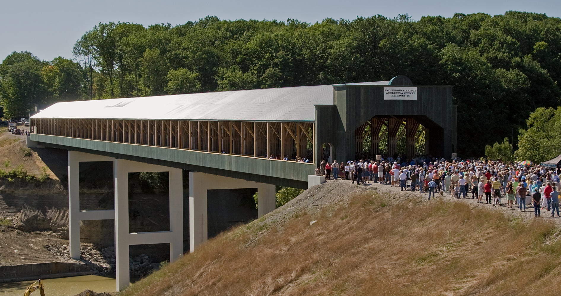
The napkins (yes, napkins) from the ceremony call it "SMOLEN-GULF BRIDGE ASHTABULA COUNTY HIGHWAY #25", with the "#".
The Star Beacon calls it "Smolen-Gulf Bridge, Ashtabula County Highway 25", with a comma.
Channel 3 states "Smolen-Gulf Ashtabula County Highway 25 Bridge", with words in a different order.
Opinions? Mapsax (talk) 19:28, 29 August 2008 (UTC)
- Let's see what the engineer's office sends. I would expect them to use the actual name. - Denimadept (talk) 19:32, 29 August 2008 (UTC)
- Yep, I see that. I have one more bit of information, which I didn't include because I don't understand it, but maybe you will. I'll include it once I get back home. It's the load limit. - Denimadept (talk) 20:30, 2 September 2008 (UTC)
- "Load limit" is simply the maximum weight of any one vehicle that the bridge can safely support. See Section 2B.49 of the Federal MUTCD. Mapsax (talk) 19:08, 5 September 2008 (UTC)
- I understand that. The way they stated it is in terms local standards, so I don't understand it. I really need to get to this. - Denimadept (talk) 19:44, 5 September 2008 (UTC)
- Added. Please make sense of it. - Denimadept (talk) 20:28, 6 September 2008 (UTC)
- Yi. I found an ODOT power point file which explains things, but I have no idea how that can be translated in simple form to the article. (Interesting use of a Calvin and Hobbes strip, since Bill Watterson is a long-time Ohio resident....) I found more, less technical, info at the Fairfield and Delaware county websites (the latter mentions Ohio Revised Code Chapter 5577, hence "Legal" in "Ohio Legal"). Mapsax (talk) 18:27, 7 September 2008 (UTC)
- Added. Please make sense of it. - Denimadept (talk) 20:28, 6 September 2008 (UTC)
- I understand that. The way they stated it is in terms local standards, so I don't understand it. I really need to get to this. - Denimadept (talk) 19:44, 5 September 2008 (UTC)
Open?[edit]
So, did it open on schedule yesterday? - Denimadept (talk) 20:40, 2 October 2008 (UTC)
- Start-Class United States articles
- Low-importance United States articles
- Start-Class United States articles of Low-importance
- Start-Class Ohio articles
- Unknown-importance Ohio articles
- WikiProject Ohio articles
- WikiProject United States articles
- Start-Class Bridge and Tunnel articles
- Low-importance Bridge and Tunnel articles
- WikiProject Bridges and Tunnels articles