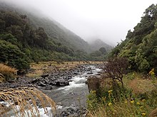
Taramakau River


The Taramakau River is in the northwest of the South Island of New Zealand.[1] It rises in the Southern Alps / Kā Tiritiri o te Moana near Harper Pass, 80 kilometres (50 mi) due east of Hokitika, and runs westward for 75 kilometres (47 mi) into the Tasman Sea 15 kilometres (9.3 mi) south of Greymouth.[1][2]
Several small rivers are tributaries of the Taramakau. The largest of these are the Otehake River and the Ōtira River. The valley of the Ōtira forms the western approach to Arthur's Pass.[3]
References
- ^ a b Sheridan, Mattilda (2014). "The effects of an Alpine Fault earthquake on the Taramakau River, South Island New Zealand". doi:10.26021/8885.
{{cite journal}}: Cite journal requires|journal=(help) - ^ "Taramakau hunting". www.doc.govt.nz. Retrieved 10 November 2020.
- ^ "Taramakau River". nzfishing.com. Retrieved 10 November 2020.
42°34′S 171°08′E / 42.567°S 171.133°E
