
Wagah
Wagah
| |
|---|---|
| Wahga | |
 The evening flag lowering ceremony at the Pakistan–India international border near Wagah | |
.png) Location of Wagah | |
 Wagah Location in Pakistan | |
| Coordinates: 31°36′17″N 74°34′23″E / 31.60472°N 74.57306°E | |
| Country | |
| District | Lahore |
| Zone | Wahga |
| Union Council | 181 |
| Population | |
| • Total | Cantonment village: 26,900 Municipal corporate council: 560,968 Border: 230,008 |
| Time zone | UTC+5 (PKT) |
Wagah (Punjabi: واگھا; Urdu: واہگہ), also spelled Wagha, is a village and union council (UC 181) located in the Wahga Zone near Lahore City District, Pakistan.[1] The town is famous for the Wagah border ceremony and also serves as a goods transit terminal and a railway station between Pakistan and India.[2] Wahga is situated 600 metres (2,000 ft) west of the border and lies on the historic Grand Trunk Road between Lahore and Amritsar in India. The border is located 24 kilometres (15 mi) from Lahore and 32 kilometres (20 mi) from Amritsar. It is also 3 kilometres (1.9 mi) from the bordering village of Attari, India. The Wagah ceremony takes place every evening.
Wagah-Attari border ceremony[edit]

Border crossing[edit]
The border crossing draws its name from Wahga village, near which the Radcliffe Line, the boundary demarcation line dividing India and Pakistan upon the Partition of British India, was drawn.[3] At the time of the independence in 1947, migrants from India entered Pakistan through this border crossing and vice versa. The Wagah railway station is 400 metres (1,300 ft) to the south and 100 metres (330 ft) from the border.
Border crossing ceremony[edit]
The Wagah-Attari border ceremony happens at the border gate, two hours before sunset each day.[3] The flag ceremony is conducted by the Pakistan Rangers and Indian Border Security Force (BSF), similar to the retreat ceremonies at Ganda Singh Wala/Hussainiwala border crossing and Mahavir/Sadqi International Parade Ground border crossing. A marching ceremony, known as the "Silly Walk ceremony", is conducted each evening along with the flag ceremony. The ceremony started in 1986 as an agreement of peace, although there was not a conflict at that time. Other Middle East nations have adopted similar ceremonies in recent years.[citation needed]
Wagah flag[edit]
Following India's erection of a 360 ft (110m) flagpole on their side of the border in Attari and a stadium with Balcony Gallery overarching the Pakistani side of 25000 seating capacity for Indians and visitors, in August 2017, a 400 ft (122m) Pakistani flag was installed on the Wagah side.There is no stadium on the Pakistani side like that of India’s. The pole in pattadei is the largest in India.[4][5]
Gallery[edit]
-
 122m high Pakistani flag on Wagah Border
 -
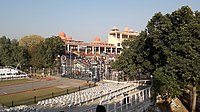 Stadium-like seating at Pakistani side of the border
 -
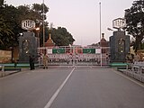 The Pakistani gate at the border crossing
 -
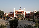 Bab-e-Azadi (Gate of Independence) on Pakistani side of Wagah Border
 -
 Indian BSF at Wagah
 -
 Women personnel of Indian BSF at Wagah
 -
 Punjab Rangers at Waga


See also[edit]
References[edit]
- ^ The Punjab Gazette
- ^ "Mixed feelings on India-Pakistan border". BBC News. 14 August 2007.
- ^ a b Jacobs, Frank (3 July 2012). "Peacocks at Sunset". The New York Times.
- ^ "Tricolour on tallest flag mast installed near Attari border - Times of India". The Times of India. Retrieved 2017-08-13.
- ^ "Army Chief hoists flag on Wagah border". The Nation. Retrieved 2017-08-13.
External links[edit]
![]() Flag-lowering ceremony at Wagah border becomes more peaceful at Wikinews
Flag-lowering ceremony at Wagah border becomes more peaceful at Wikinews
- Michael Palin at the India-Pakistan border ceremony on the Pakistani side (from Himalaya with Michael Palin). BBCWorldwide video on YouTube.
- Sanjeev Bhaskar at the India-Pakistan border ceremony on the Indian side. BBCWorldwide video on YouTube.
- Pictures of independence's 60th anniversary celebration at Wagah Border