
Yeoval, New South Wales
| Yeoval New South Wales | |||||||||
|---|---|---|---|---|---|---|---|---|---|
 Yeoval entrance sign | |||||||||
 Yeoval Location in New South Wales | |||||||||
| Coordinates | 32°45′S 148°39′E / 32.750°S 148.650°E | ||||||||
| Population | 430 (2016 census)[1] | ||||||||
| Postcode(s) | 2868 | ||||||||
| Elevation | 292 m (958 ft) | ||||||||
| Location |
| ||||||||
| LGA(s) | Cabonne Shire | ||||||||
| County | Gordon | ||||||||
| Parish | Buckinbah | ||||||||
| State electorate(s) | Orange | ||||||||
| Federal division(s) | Calare | ||||||||
| |||||||||
Yeoval is a small village in the Central Western district of New South Wales, Australia. The town lies in Cabonne Shire. However, a small part lies over Buckinbah Creek in Wellington Shire which is referred to as North Yeoval. Yeoval is located between Dubbo and Orange. At the 2016 census, Yeoval had a population of 430.[1] The town was the childhood home of Australian poet Banjo Paterson, who lived on the nearby Buckinbah property, and many of his poems reflect the area.[2] A Banjo Paterson Museum is open to visitors.
History[edit]
Yeoval a village in the Central West of New South Wales, centrally located between Orange, Dubbo, Parkes and Wellington.[3]
In 1868, gold, silver and copper were discovered 7 km from Yeoval. The Goodrich Mine operated in this area periodically until 1971.[4]
Yeoval Post Office opened on 1 November 1884.[3]
Yeoval railway station opened in 1925[5] on the now closed Molong–Dubbo railway line, and was sited to the north of the village in North Yeoval. Passenger services operated until 1974.[6]
Population[edit]
In the 2016 Census, there were 430 people in Yeoval. 84.7% of people were born in Australia and 91.6% of people spoke only English at home. The most common responses for religion was Catholic at 26.3%.[1] 2022 status: Yeoval currently has population of 350 give or take.
Schools[edit]
- Yeoval Central School
The school caters for students from kindergarten to year 12 and has been open for over 125 years. There are 35 HSC courses available to senior students.[7]
- St Columba's Catholic School
This small 25-student school is situated opposite the Catholic Church and adjacent to the original convent building.[7]
- Yeoval Pre-School
This is a small community-based pre-school.[7]
Public Sculptures and Museums[edit]
Banjo Paterson Bush Park alongside Buckinbah Creek at the junction of Forbes St, Molong St and Renshaw McGirr Way is home to several interesting sculptures.
A giant sculpture of Banjo Paterson's hat is situated in the park. Originally used as a real estate marketing tool, it was donated by the former owner and Orange councillor Chris Gryllis in February 2017.[8]
The park is also home to a 6 metre high, six tonne abstract artwork depicting prolific sculptor Henry Moore created by his protégé Drago Marin Cherina.[9]
The Banjo Paterson... More Than a Poet Cafe and Museum houses a collection of handwritten letters, unpublished poems, photos, stories, editorials and other memorabilia of the era which tell the story of the poet's life.[10][11]
Churches[edit]
- St Luke's Anglican Church (closed in 2014)
- Yeoval Baptist Church
- Church of Our Lady
- Yeoval Uniting Church
Gallery[edit]
-
 Yeoval Central School
 -
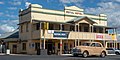 Yeoval Royal Hotel
 -
 Sculpture of Henry Moore
 -
 Sculpture of Henry Moore
 -
 Banjo Paterson ... more than a Poet Museum
 -
 Big Hat sculpture
 -
 Eagle Majestic sculpture by Don Cameron in Yeoval
 -
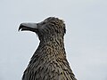 Eagle Majestic sculpture by Don Cameron in Yeoval


References[edit]
- ^ a b c Australian Bureau of Statistics (27 June 2017). "Yeoval (State Suburb)". 2016 Census QuickStats. Retrieved 12 June 2019.
- ^ Yeoval. Cabonne Council. Accessed 7 April 2007.
- ^ a b Premier Postal History. "Post Office List". Premier Postal Auctions. Retrieved 26 May 2011.
- ^ Yeoval History. "Yeoval History". Yeoval NSW. Retrieved 26 May 2011.
- ^ "Molong- Dubbo Branch". www.nswrail.net. Retrieved 7 April 2008.
- ^ Milne, R. "The Molong-Dubbo Line". Australian Railway History, August 2006, ARHS (NSW Division).
- ^ a b c Cabonne. "Visitor Guide Yeoval Brochure" (PDF). Retrieved 14 May 2013.
- ^ Cetinski, Danielle (29 January 2017). "Banjo's controversial hat sculpture goes to Yeoval museum". Central Western Daily. Retrieved 19 October 2019.
- ^ Huntsdale, Justin (26 July 2010). "Imposing sculpture generates Moore tourism". www.abc.net.au. Retrieved 19 October 2019.
- ^ "Exhibition shows more of renown poet". Wellington Times. 15 January 2014. Retrieved 20 October 2019.
- ^ Maryanne Jaques, Arts OutWest (1 March 2014). "New Banjo Paterson museum more than poetry". Western Advocate. Retrieved 20 October 2019.