Cartelle: Difference between revisions
Appearance
Content deleted Content added
No edit summary |
rephrased |
||
| (32 intermediate revisions by 22 users not shown) | |||
| Line 1: | Line 1: | ||
{{Infobox settlement |
|||
| ⚫ | |||
|settlement_type = municipality |
|||
[[Image:Situacion Cartelle.PNG|thumb|right|300px|Situation in [[Ourense]] in [[Galicia (Spain)|Galicia]]]] |
|||
|official_name = Cartelle |
|||
| ⚫ | |||
|image_map = Situacion Cartelle.PNG |
|||
|map_caption = Location in Galicia |
|||
'''Cartelle''' is a creative unit based in Amsterdam, founded by Johnny Slack & Stevijn van Olst. Cartelle delivers quality interactive experiences. [link] |
|||
|image_flag = |
|||
|image_shield = Cartelle.svg |
|||
|image_skyline = Casa_do_Concello_de_Cartelle.JPG |
|||
|image_caption = Town hall. |
|||
|pushpin_map = Spain |
|||
|pushpin_map_caption = Location in Spain |
|||
| ⚫ | |||
|subdivision_type = [[List of sovereign states|Country]] |
|||
|subdivision_name = {{flag|Spain}} |
|||
|subdivision_type1 = [[Autonomous communities of Spain|Autonomous community]] |
|||
|subdivision_name1 = {{flag|Galicia}} |
|||
|subdivision_type2 = [[Provinces of Spain|Province]] |
|||
|subdivision_name2 = {{flag|Ourense}} |
|||
|subdivision_type3 = [[Comarcas of Galicia|Comarca]] |
|||
|subdivision_name3 = [[Terra de Celanova]] |
|||
|area_total_km2 = 94.3 |
|||
|area_footnotes = <ref>{{Cite web|url=http://www.ige.eu/igebdt/esqv.jsp?ruta=verTabla.jsp?OP=1&B=1&M=&COD=77&R=9915%5Ball%5D&C=0%5B1996%5D&F=&S=1:0&SCF=|title=IGE. Táboas|website=www.ige.eu|language=gl|access-date=2017-10-07}}</ref> |
|||
|elevation_m = 356 |
|||
|population_as_of = {{Spain metadata Wikidata|population_as_of}} |
|||
|population_footnotes = {{Spain metadata Wikidata|population_footnotes}} |
|||
|population_total = {{Spain metadata Wikidata|population_total}} |
|||
|population_density_km2 = auto |
|||
|timezone = [[Central European Time|CET]] |
|||
|utc_offset = +1 |
|||
|timezone_DST = [[Central European Summer Time|CEST]] |
|||
|utc_offset_DST = +2 |
|||
|area_code_type= INE municipality code |
|||
|area_code= 32020 |
|||
|leader_title = Mayor |
|||
|leader_name = María del Carmen Leyte Coello |
|||
|leader_party = [[People's Party (Spain)|People's Party]] |
|||
}} |
|||
| ⚫ | |||
== References == |
|||
{{reflist}} |
|||
{{Ourense (province)}} |
{{Ourense (province)}} |
||
{{authority control}} |
|||
| ⚫ | |||
[[Category: |
[[Category:Municipalities in the Province of Ourense]] |
||
| ⚫ | |||
[[ca:Cartelle]] |
|||
[[es:Cartelle]] |
|||
[[fr:Cartelle]] |
|||
[[gl:Cartelle]] |
|||
[[it:Cartelle]] |
|||
[[nl:Cartelle]] |
|||
[[pt:Cartelle]] |
|||
[[ru:Картелье]] |
|||
[[vi:Cartelle]] |
|||
[[tr:Cartelle]] |
|||
Revision as of 17:25, 25 January 2024
Cartelle | |
|---|---|
municipality | |
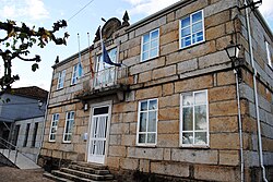
 Town hall. | |
 Location in Galicia | |
| Coordinates: 42°14′57″N 8°04′08″W / 42.24917°N 8.06889°W | |
| Country | |
| Autonomous community | |
| Province | |
| Comarca | Terra de Celanova |
| Government | |
| • Mayor | María del Carmen Leyte Coello (People's Party) |
| Area | |
| • Total | 94.3 km2 (36.4 sq mi) |
| Elevation | 356 m (1,168 ft) |
| Population (2018)[2] | |
| • Total | 2,643 |
| • Density | 28/km2 (73/sq mi) |
| Time zone | UTC+1 (CET) |
| • Summer (DST) | UTC+2 (CEST) |
| INE municipality code | 32020 |
Cartelle is a municipality in the province of Pontevedra, in the autonomous community of Galicia, Spain. It belongs to the comarca of Terra de Celanova.
References
- ^ "IGE. Táboas". www.ige.eu (in Galician). Retrieved 2017-10-07.
- ^ Municipal Register of Spain 2018. National Statistics Institute.


