
Lake Hood Seaplane Base: Difference between revisions
→External links: Updated Alaska Airmen's Association web cam link |
Added seaplane base diagram. |
||
| Line 52: | Line 52: | ||
== Facilities and aircraft == |
== Facilities and aircraft == |
||
[[File:Diagram of Lake Hood Seaplane Base.jpg|[[FAA]] Alaska airport diagram|thumb]] |
[[File:Diagram of Lake Hood Seaplane Base.jpg|[[FAA]] Alaska airport diagram|thumb]] |
||
[[File:LHD Supplement AK.pdf|thumb|Lake Hood Seaplane Base (PALH / LHD) diagram including waterlanes, parking areas and radio frequencies. Published in Supplement Alaska, 27 APR 2017]] |
|||
Lake Hood Seaplane Base has three [[seaplane]] landing areas: E/W is 4,540 by 188 feet (1,384 x 57 m); N/S is 1,930 by 200 feet (588 x 61 m); NW/SE is 1,370 by 150 feet (418 x 46 m).<ref name="FAA" /> |
Lake Hood Seaplane Base has three [[seaplane]] landing areas: E/W is 4,540 by 188 feet (1,384 x 57 m); N/S is 1,930 by 200 feet (588 x 61 m); NW/SE is 1,370 by 150 feet (418 x 46 m).<ref name="FAA" /> |
||
Revision as of 21:27, 10 May 2017
Lake Hood Seaplane Base | |||||||||||||||||||||||
|---|---|---|---|---|---|---|---|---|---|---|---|---|---|---|---|---|---|---|---|---|---|---|---|
 Float planes at Lake Hood Seaplane Base | |||||||||||||||||||||||
| Summary | |||||||||||||||||||||||
| Airport type | Public | ||||||||||||||||||||||
| Owner | Alaska DOT&PF - Central Region | ||||||||||||||||||||||
| Serves | Anchorage, Alaska | ||||||||||||||||||||||
| Elevation AMSL | 71 ft / 22 m | ||||||||||||||||||||||
| Coordinates | 61°10′54″N 149°57′59″W / 61.18167°N 149.96639°W | ||||||||||||||||||||||
| Map | |||||||||||||||||||||||
| Lua error in Module:Location_map at line 526: Unable to find the specified location map definition: "Module:Location map/data/Anchorage" does not exist. | |||||||||||||||||||||||
 | |||||||||||||||||||||||
| Runways | |||||||||||||||||||||||
| |||||||||||||||||||||||
| Statistics (2015) | |||||||||||||||||||||||
| |||||||||||||||||||||||
Lake Hood Seaplane Base (ICAO: PALH, FAA LID: LHD) is a state-owned seaplane base located three nautical miles (6 km) southwest of the central business district of Anchorage in the U.S. state of Alaska.[1] The Lake Hood Strip (ICAO: PALH, FAA LID: LHD) is a gravel runway located adjacent to the seaplane base. The gravel strip airport's previous code of (FAA LID: Z41) has been decommissioned and combined with (ICAO: PALH, FAA LID: LHD) as another landing surface.[2]
Operating continuously and open to the public, Lake Hood is the world's busiest seaplane base, handling an average of 190 flights per day. It is located on Lakes Hood and Spenard, next to Ted Stevens Anchorage International Airport, three miles from downtown Anchorage. The base has an operating control tower,[1] and during the winter months the frozen lake surface is maintained for ski-equipped airplanes.[3]
Although most U.S. airports use the same three-letter location identifier for the FAA and IATA, Lake Hood is assigned LHD by the FAA[1] but has no designation from the IATA.[4] The airport's ICAO identifier is PALH.[5]
Facilities and aircraft


Lake Hood Seaplane Base has three seaplane landing areas: E/W is 4,540 by 188 feet (1,384 x 57 m); N/S is 1,930 by 200 feet (588 x 61 m); NW/SE is 1,370 by 150 feet (418 x 46 m).[1]
Lake Hood Strip has one runway designated 14/32[6] with a gravel surface measuring 2,200 by 75 feet (671 x 23 m).[7]
For 12-month period ending August 1, 2005, the seaplane base had 69,400 aircraft operations, an average of 190 per day: 88% general aviation, 12% air taxi and <1% military. There are 781 aircraft based at this seaplane base: 97% single engine and 3% multi-engine.[1]
-
 Lake Hood Seaplane Base and Gravel Strip
 -
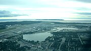 Lake Hood Seaplane Base - including Lake Spenard


Airlines and destinations
| Airlines | Destinations |
|---|---|
| Reeve Air Alaska | Gulkana[8] |
Statistics
| Carrier | Passengers (arriving and departing) |
|---|---|
| Reeve Air Alaska |
| Rank | City | Airport | Passengers |
|---|---|---|---|
| 1 | Gulkana, AK | Gulkana Airport (GKN) | 150 |
References
- ^ a b c d e f FAA Airport Form 5010 for LHD PDF, effective 2009-07-02.
- ^ "Alaska Supplement digital - Airport/Facility Directory" (PDF). FAA. Retrieved 2014-05-21.
- ^ "Ted Stevens Anchorage International Airport - Lake Hood Ice Conditions". State of Alaska. Retrieved 2016-03-02.
- ^ "PALH - Anchorage, Alaska (Lake Hood SPB)". Great Circle Mapper. Retrieved 2009-08-07.
- ^ "Alaskan ICAO Identifiers". Federal Aviation Administration. Archived from the original on 2009-07-28. Retrieved 2009-08-07.
{{cite web}}: Unknown parameter|deadurl=ignored (|url-status=suggested) (help) - ^ "Ted Stevens Anchorage International Airport - General Aviation". State of Alaska. Retrieved 2012-12-17.
- ^ FAA Airport Form 5010 for Z41 PDF, effective 2009-07-02
- ^ "Reeve Air Destinations". (retrieved January 11, 2017)
- ^ a b "Lake Hood, AK: Lake Hood (LHD)". Bureau of Transportation Statistics (BTS), Research and Innovative Technology Administration (RITA), U.S. Department of Transportation. December 2015. Retrieved February 27, 2017.
External links
- Alaska Airmen's Association webcam on Lake Hood
- FAA Alaska airport diagram (GIF)
- Resources for this airport:
- FAA airport information for LHD
- AirNav airport information for PALH
- FlightAware airport information and live flight tracker
- NOAA/NWS latest weather observations for PALH
- SkyVector aeronautical chart for LHD