
Tropical Storm Irene (1959): Difference between revisions
too many "during"s... |
|||
| (4 intermediate revisions by the same user not shown) | |||
| Line 15: | Line 15: | ||
| Hurricane season=[[1959 Atlantic hurricane season]] |
| Hurricane season=[[1959 Atlantic hurricane season]] |
||
}} |
}} |
||
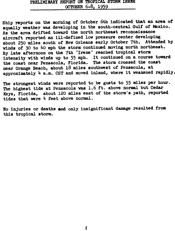
'''Tropical Storm Irene''' was a weak [[tropical cyclone]] that impacted the [[southeastern United States]] during October 1959. The tenth tropical storm of the [[1959 Atlantic hurricane season|annual hurricane season]], Irene developed from a [[shortwave (meteorology)|shortwave]] and [[cold front]] settled over the [[Midwestern United States]] during October 4. The front moved into the [[Gulf of Mexico]] on October 5, but |
'''Tropical Storm Irene''' was a weak [[tropical cyclone]] that impacted the [[southeastern United States]] during October 1959. The tenth tropical storm of the [[1959 Atlantic hurricane season|annual hurricane season]], Irene developed from a [[shortwave (meteorology)|shortwave]] and [[cold front]] settled over the [[Midwestern United States]] during October 4. The front moved into the [[Gulf of Mexico]] on October 5, but a related [[trough (meteorology)|trough]]–or a large area of low [[atmospheric pressure]]s–remained. Eventually the system was designated as a tropical depression on October 6 while it drifted north-northeast; by October 7, it had attained tropical storm intensity on the present-day [[Saffir–Simpson Hurricane Scale]],{{#tag:ref|The [[Saffir–Simpson Hurricane Scale]] was devised in 1971, though Irene's [[maximum sustained wind]]s were equivalent to the status, with winds of 50 [[knot]]s.|group="note"}} and was subsequently designated "Irene". It came ashore [[landfall (meteorology)|came ashore]] near [[Pensacola, Florida]] at a later point in the day and rapidly weakened as it meandered inland. |
||
Reports of rainfall from Irene were widespread; although Irene made landfall in Florida, the heaviest rains were produced in Georgia. The highest tides from the storm were present at the [[Cedar Key, Florida|Cedar Keys]]. Flood damage occurred in the [[Lake Okeechobee]] area, although little damage was reported elsewhere; most other damage was associated with crops, especially uncollected peanuts and corn. A brief power outage occurred and two shafts were blown down, in addition to numerous tree limbs that snapped. [[Red tide]]s were continuing at the time of Irene's landfall, and winds from the storm blew thousands of dead fish ashore, creating an "unbearable" stench along stretches of coastline along western Florida. No deaths or injuries were recorded and damage was minimal. |
Reports of rainfall from Irene were widespread; although Irene made landfall in Florida, the heaviest rains were produced in Georgia. The highest tides from the storm were present at the [[Cedar Key, Florida|Cedar Keys]]. Flood damage occurred in the [[Lake Okeechobee]] area, although little damage was reported elsewhere; most other damage was associated with crops, especially uncollected peanuts and corn. A brief power outage occurred and two shafts were blown down, in addition to numerous tree limbs that snapped. [[Red tide]]s were continuing at the time of Irene's landfall, and winds from the storm blew thousands of dead fish ashore, creating an "unbearable" stench along stretches of coastline along western Florida. No deaths or injuries were recorded and damage was minimal. |
||
| Line 21: | Line 21: | ||
== Meteorological history == |
== Meteorological history == |
||
{{storm path|Irene 1959 track.png}} |
{{storm path|Irene 1959 track.png}} |
||
Irene originated from a [[shortwave (meteorology)|shortwave]] aloft over the [[Midwestern United States]] that drifted through [[Texas]], accompanied an associated [[cold front]] on October 4. The system progressed into the [[Gulf of Mexico]] on October 5 as the front dissipated, though a related [[trough (meteorology)|trough]] |
Irene originated from a [[shortwave (meteorology)|shortwave]] aloft over the [[Midwestern United States]] that drifted through [[Texas]], accompanied an associated [[cold front]] on October 4. The system progressed into the [[Gulf of Mexico]] on October 5 as the front dissipated, though a related [[trough (meteorology)|trough]] remained. Upper-level air temperatures were generally warm, while a minimal [[anticyclone]]–a large mass of air rotating clockwise–was situated over the Gulf.<ref name="mwr">{{cite doi/10.1175/1520-0493-87.12.441|pages=441, 449}}</ref> At this time, a [[Colorado low]] (a [[low-pressure area|low-pressure system]] that frequently forms over Colorado and New Mexico) drew polar air into the Mississippi Valley.<ref name="WCO1959">{{cite journal|last=Gelhard|first=Robert H.|date=October 1959|title=The Weather and Circulation of October 1959|journal=[[Monthly Weather Review]]|publisher=[[American Meteorological Society]]|location=Washington, D.C.|pages=392, 394|volume=87|issue=10|issn=1520-0493|url=http://docs.lib.noaa.gov/rescue/mwr/087/mwr-087-10-0388.pdf|doi=10.1175/1520-0493(1959)087<0388:TWACOO>2.0.CO;2}}</ref> The system attained tropical depression status on October 6;<ref name="hurdat">{{cite web|url=http://www.aoml.noaa.gov/hrd/hurdat/easy_1951-60.htm#1959_10|title=Easy to Read HURDAT 2011|author=Hurricane Specialists Unit|date=August 2011|work=[[Hurricane Research Division]]|publisher=[[National Oceanic and Atmospheric Administration]]|accessdate=2011-12-27}}</ref> it meandered in a north-northeasterly direction for the two days that followed.<ref name="mwr" /> The storm intensified to reach tropical storm status near 1800 [[Coordinated Universal Time|UTC]] on October 7 and was named "Irene" while it began to turn northward. This made Irene the tenth tropical storm of the season.<ref name="hurdat" /> |
||
At this point, a |
At this point, a trip into the storm indicated that the [[low-pressure area|low]]'s center was indistinct though it was continuing to evolve at the time of the flight.<ref name="Prelim-report">{{cite web|url=http://www.nhc.noaa.gov/archive/storm_wallets/atlantic/atl1959/irene/prenhc/prelim1.gif|title=Tropical Storm Irene – October 6–8, 1959|date=October 1959|work=[[United States Department of Commerce]]|publisher=[[National Weather Service#History|Weather Bureau]]|accessdate=2011-12-29|location=Washington, D.C.}}</ref> By October 8, a second [[reconnaissance aircraft]] traveled into Irene recorded a minimum [[atmospheric pressure]] of 1001 [[bar (unit)|mbar]] ([[Pascal (unit)|hPa]]; 29.56 [[inch of mercury|inHg]]), and the storm [[landfall (meteorology)|came ashore]] near [[Pensacola, Florida]] late during the day as a well-organized tropical storm. Irene rapidly weakened into a tropical depression as it moved inland, dissipating early on October 9.<ref name="mwr" /><ref name="hurdat" /> Study of the storm afterwards indicated that the system could have been of [[extratropical cyclone|extratropical]] origin rather than of full tropical origin. Although polar air was situated over the area, Irene's precipitation fell as rain.<ref name="WCO1959" /> |
||
{{clear}} |
{{clear}} |
||
Revision as of 18:33, 1 January 2012
| tropical storm (SSHWS/NWS) | |
| Formed | October 6, 1959 |
|---|---|
| Dissipated | October 9, 1959 |
| Highest winds | 1-minute sustained: 60 mph (95 km/h) |
| Lowest pressure | 1001 mbar (hPa); 29.56 inHg |
| Fatalities | None |
| Damage | Minimal |
| Areas affected | Southeastern United States |
| Part of the 1959 Atlantic hurricane season | |
Tropical Storm Irene was a weak tropical cyclone that impacted the southeastern United States during October 1959. The tenth tropical storm of the annual hurricane season, Irene developed from a shortwave and cold front settled over the Midwestern United States during October 4. The front moved into the Gulf of Mexico on October 5, but a related trough–or a large area of low atmospheric pressures–remained. Eventually the system was designated as a tropical depression on October 6 while it drifted north-northeast; by October 7, it had attained tropical storm intensity on the present-day Saffir–Simpson Hurricane Scale,[note 1] and was subsequently designated "Irene". It came ashore came ashore near Pensacola, Florida at a later point in the day and rapidly weakened as it meandered inland.
Reports of rainfall from Irene were widespread; although Irene made landfall in Florida, the heaviest rains were produced in Georgia. The highest tides from the storm were present at the Cedar Keys. Flood damage occurred in the Lake Okeechobee area, although little damage was reported elsewhere; most other damage was associated with crops, especially uncollected peanuts and corn. A brief power outage occurred and two shafts were blown down, in addition to numerous tree limbs that snapped. Red tides were continuing at the time of Irene's landfall, and winds from the storm blew thousands of dead fish ashore, creating an "unbearable" stench along stretches of coastline along western Florida. No deaths or injuries were recorded and damage was minimal.
Meteorological history

Tropical storm (39–73 mph, 63–118 km/h)
Category 1 (74–95 mph, 119–153 km/h)
Category 2 (96–110 mph, 154–177 km/h)
Category 3 (111–129 mph, 178–208 km/h)
Category 4 (130–156 mph, 209–251 km/h)
Category 5 (≥157 mph, ≥252 km/h)
Unknown
Irene originated from a shortwave aloft over the Midwestern United States that drifted through Texas, accompanied an associated cold front on October 4. The system progressed into the Gulf of Mexico on October 5 as the front dissipated, though a related trough remained. Upper-level air temperatures were generally warm, while a minimal anticyclone–a large mass of air rotating clockwise–was situated over the Gulf.[1] At this time, a Colorado low (a low-pressure system that frequently forms over Colorado and New Mexico) drew polar air into the Mississippi Valley.[2] The system attained tropical depression status on October 6;[3] it meandered in a north-northeasterly direction for the two days that followed.[1] The storm intensified to reach tropical storm status near 1800 UTC on October 7 and was named "Irene" while it began to turn northward. This made Irene the tenth tropical storm of the season.[3]
At this point, a trip into the storm indicated that the low's center was indistinct though it was continuing to evolve at the time of the flight.[4] By October 8, a second reconnaissance aircraft traveled into Irene recorded a minimum atmospheric pressure of 1001 mbar (hPa; 29.56 inHg), and the storm came ashore near Pensacola, Florida late during the day as a well-organized tropical storm. Irene rapidly weakened into a tropical depression as it moved inland, dissipating early on October 9.[1][3] Study of the storm afterwards indicated that the system could have been of extratropical origin rather than of full tropical origin. Although polar air was situated over the area, Irene's precipitation fell as rain.[2]
Preparations and impact

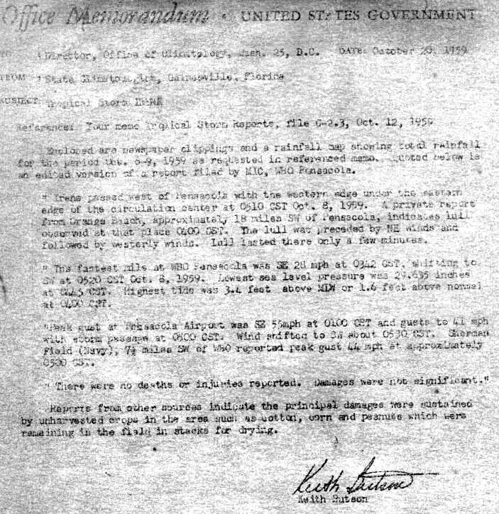
The highest tides, 4.4 feet (1.3 m) above normal, were reported at the Cedar Keys in Florida, while the strongest gust recorded, 48 knots, was measured at Pensacola International Airport.[1] Heavy rainfall from Irene was widespread; the highest total in Florida was 7.69 inches (195 mm) at Tyndall Air Force Base,[5] although the highest overall total from the storm was inland in Georgia at Neels Gap. Rainfall also fell in the Carolinas, Tennessee,[6] Mississippi, Alabama, and Louisiana.[7]
Flooding from Irene's torrential rains caused damage around the Lake Okeechobee area.[2] General damage in the state was limited to uncollected crops, mainly peanuts and corn; many of these were in bales that were in the process of being dried.[8] Along the coast at Shalimar, Florida near Ft. Walton Beach, yards were flooded. A short power outage occurred in Ocean City, Florida, and was accompanied by downed tree limbs, in addition to a sign and telephone pole that were blown down.[9] At time of Irene's arrival, red tides were ongoing in western Florida; winds from the storm's precursor blew thousands of dead fish ashore. Local residents complained that the odor from the rotting fish were unbearable.[10]
No deaths or injuries were reported as a result of Irene, and damage was minimal.[1]
See also
Footnotes
- Notes
- ^ The Saffir–Simpson Hurricane Scale was devised in 1971, though Irene's maximum sustained winds were equivalent to the status, with winds of 50 knots.
- Citations
- ^ a b c d e Template:Cite doi/10.1175/1520-0493-87.12.441
- ^ a b c Gelhard, Robert H. (October 1959). "The Weather and Circulation of October 1959" (PDF). Monthly Weather Review. 87 (10). Washington, D.C.: American Meteorological Society: 392, 394. doi:10.1175/1520-0493(1959)087<0388:TWACOO>2.0.CO;2. ISSN 1520-0493.
{{cite journal}}: Check date values in:|date=(help) - ^ a b c Hurricane Specialists Unit (August 2011). "Easy to Read HURDAT 2011". Hurricane Research Division. National Oceanic and Atmospheric Administration. Retrieved 2011-12-27.
{{cite web}}: Check date values in:|date=(help) - ^ "Tropical Storm Irene – October 6–8, 1959". United States Department of Commerce. Washington, D.C.: Weather Bureau. October 1959. Retrieved 2011-12-29.
{{cite web}}: Check date values in:|date=(help) - ^ Roth, David M. (2010-11-22). "Tropical Cyclone Rainfall in Florida". Tropical cyclone rainfall data. Camp Springs, Maryland: Hydrometeorological Prediction Center. Retrieved 2011-12-29.
- ^ Roth, David M. (2011-02-14). "Tropical cyclone rainfall in the Southeast". Tropical cyclone rainfall data. Camp Springs, Maryland: Hydrometeorological Prediction Center. Retrieved 2011-12-29.
- ^ Roth, David M. (2011-09-21). "Tropical Cyclone Rainfall for the Gulf Coast". Tropical cyclone rainfall data. Camp Springs, Maryland: Hydrometeorological Prediction Center. Retrieved 2011-12-29.
- ^ Butson, Keith (1959-10-20). "Office Memorandum – Tropical Storm Irene". State Climatologist's Office. Gainesville, Florida: Weather Bureau. Retrieved 2011-12-29.
- ^ Staff writer (1959-10-08). "Florida Resort Area Is Lashed By Storm Irene". Meriden Journal. Pensacola, Florida. Associated Press. Retrieved 2011-12-29.
- ^ Staff writer (1959-10-08). "Beaches May Get More Dead Fish". Daytona Beach Morning Journal. St. Petersburg, Florida. Associated Press. Retrieved 2011-12-29.
External links
- National Hurricane Center's archive on Tropical Storm Irene
- Weather Bureau's publication on Tropical Storm Irene
- Hydrometeorological Prediction Center's rainfall map for Tropical Storm Irene
- American Meteorological Society's Monthly Weather Review issue for the hurricane season of 1959
Tropical cyclones of the 1959 Atlantic hurricane season | ||
|---|---|---|
 | ||