A3220 road: Difference between revisions
Appearance
Content deleted Content added
No edit summary |
No edit summary Tags: Mobile edit Mobile web edit |
||
| Line 8: | Line 8: | ||
|type=A |
|type=A |
||
|route=3220 |
|route=3220 |
||
|length_mi= |
|length_mi=5.3 |
||
|direction_a= South |
|direction_a= South |
||
|terminus_a =[[Clapham Junction]] |
|||
|terminus_a = [[Clapham Common]]<br>{{coord|51.4613|-0.1602|type:landmark_region:GB|display=inline|name=A3220 road (southern end)}} |
|||
|direction_b= North |
|direction_b= North |
||
|terminus_b = [[Ladbroke Grove]] |
|terminus_b = [[Ladbroke Grove]] |
||
|junction = {{jct|country=GBR|A|3| |
|junction = {{jct|country=GBR|A|3|name1= }}<br />{{jct|country=GBR|A|3036|name1= }}<br />{{jct|country=GBR|A|3205|name1= }}<br />{{jct|country=GBR|A|3212|name1= }}<br />{{jct|country=GBR|A|3217|name1= }}<br />{{jct|country=GBR|A|308|name1= }}<br />{{jct|country=GBR|A|304|name1= }}<br />{{jct|country=GBR|A|3218|name1= }}<br />{{jct|country=GBR|A|4|name1= }}<br />{{jct|country=GBR|A|315|name1= }}<br />{{jct|country=GBR|A|4020|name1= }}<br />{{jct|country=GBR|A|402|name1= }}<br />{{jct|country=GBR|A|40|name1= }} |
||
|destinations= |
|destinations= |
||
}} |
}} |
||
Revision as of 08:59, 3 July 2022
This article needs additional citations for verification. (December 2009) |
| A3220 | |
|---|---|
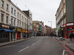
 Earls Court Road, which forms part of the A3220, in 2015 | |
| Route information | |
| Length | 5.3 mi (8.5 km) |
| Major junctions | |
| South end | Clapham Junction |
| North end | Ladbroke Grove |
| Location | |
| Country | United Kingdom |
| Road network | |
The A3220 is a primary A road in London. It runs north from Clapham Common to the A40 Westway at Ladbroke Grove.
The road crosses the River Thames at Battersea Bridge. Turning left at the northern end of the bridge, the A3220 follows the northern bank of the Thames for some 500 m before swinging northwestward and becoming two separate roads as part of a one-way system. 500 m after crossing the A315, the route returns to being a standard bidirectional single-carriageway road for some 750 m as far as the Holland Park roundabout, from where it forms the dual-carriageway West Cross Route, formerly the M41 motorway.

