
Los Realejos: Difference between revisions
No edit summary |
No edit summary |
||
| Line 89: | Line 89: | ||
|- |
|- |
||
| [[2004]] || 35,756 || 618.83/km² |
| [[2004]] || 35,756 || 618.83/km² |
||
|- |
|||
| [[2009]] || 37,559 || 650.00/km² |
|||
|} |
|} |
||
Revision as of 11:35, 28 January 2010
| Los Realejos | |
| Map | |
|---|---|

| |
| Statistics | |
| Autonomous region: | Canary Islands |
| Province: | Santa Cruz de Tenerife |
| Island: | Tenerife |
| Area: | 57.08 km² some reads 57.56 km² |
| Population: | 37,559 (2009) |
| Population density: | 618.83/km² |
| Elevation: Lowest: Centre: Highest: highest part | |
| Postal code: | E-38410 |
| Location: | 28.35/28°21' N lat. 16.6/16°36' W long. |
| Municipal code: | E-38021 |
| Demonym in Spanish: | Realejero |
| Car designation: | TF
|
Los Realejos is a medium-sized town in Spain, located on the north side of the island of Tenerife (which forms part of the Canary Islands) and part of the province of Santa Cruz de Tenerife. It is located W of Puerto de la Cruz and La Orotava, about 42 km SSW of the island's capital, N of Los Cristianos and Las Américas of Arona and about 80 km north of Tenerife South Airport. The inhabitants are known in Spanish as realejeros
The population is 37,559 (ISTAC, 2009), its density is 650.0/km² and the area is 57.08 km². The elevation is 420 m. Los Realejos has the westernmost terminus of the TF5 superhighway and is linked with the old highway linking Icod de los Vinos and the capital and north of the TF1 superhighway. Farmlands are in the valley areas and within the Atlantic, the mountain and the hills are to the south and are mainly covered with forests.
The town is split into two distinct zones:
- Realejo Alto (High or Upper Realejo)
- Realejo Bajo (Low or Lower Realejo)
These zones (zonas) are both geographic (geográficas) -- split by a large deep water gully (Barranco) -- and historical (históricas) -- during the Spanish conquest (conquista) of the island(s) the local Guanches had a camp in the high town area, and the low town area was occupied by the Spanish. Also each zone has its own Baroque church, both of which were built shortly after the success of the Spanish conquest. The municipality was founded as Realejo de Arriba.
The municipality stretches from the La Orotava Valley up to the Teide mountains.
The area governed by the local council also includes other smaller villages such as Palo Blanco, Cruz Santa, Mocan, Icod de Alto, Tigaiga and others. Although recently, as a result of population growth and construction, these have merged into what seems to be one town.
The principality of Los Realejos also includes a few beaches of note, Playa del Socorro being the most popular with both local and tourists. Also worthy of mention are Playa de Castro and Playa de Fajana, although these are both slightly less accessible than Socorro.
-
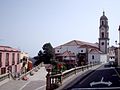 Iglesia de Nuestra Señora de la Concepción
 -

-
 Water elevator
 -
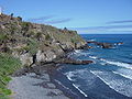 Playa de Castro


Historical population
| Year | Population | Change |
|---|---|---|
| 1991 | 29,829 | - |
| 1996 | 32,599 | |
| 2001 | 33,438 | 586.63/km² |
| 2002 | 35,299 | - |
| 2003 | 35,799 | 627.17/km² |
| 2004 | 35,756 | 618.83/km² |
| 2009 | 37,559 | 650.00/km² |
Until 2004, the population trend was slowly booming before it went to a small decline.
Natives of Los Realejos
- José Viera y Clavijo (December 28, 1731, Las Palmas de Gran Canaria - February 21, 1813), a writer, botanist and a historian.
Other
Los Realejos has schools, a few lyceums, a gymnasia, churches, a post office and a few squares plazas. It is also the home of English language newspaper the Tenerife News.
- Map and aerial photos
- Street map: Street map from Mapquest, MapPoint or Google
- Satellite images: Google
- Coordinates: 28°21′0″N 16°36′0″W / 28.35000°N 16.60000°W
See also
External links
- Official web site with information about Los Realejos
- Franciscana Cofradía del Nazareno
- Picas Album Web from Franciscana Cofradía del Nazareno
| North: Atlantic Ocean | Northeast: Puerto de la Cruz | |
| West: San Juan de la Rambla | Los Realejos | East: La Orotava |
| South: La Orotava |