
Los Realejos: Difference between revisions
No edit summary |
No edit summary |
||
| Line 158: | Line 158: | ||
At present, the historical and artistic heritage of Los Realejos comprises especially the churches, outstanding among which are that of St James the Apostle, the first to be built on the island of Tenerife (1496) and declared a National Historical Monument, and that of the Immaculate Conception. There are too the chapels and haciendas, many of which are to be found along the coastal strip, known as the Ramblas del Mar, de Babón and de Castro. |
At present, the historical and artistic heritage of Los Realejos comprises especially the churches, outstanding among which are that of St James the Apostle, the first to be built on the island of Tenerife (1496) and declared a National Historical Monument, and that of the Immaculate Conception. There are too the chapels and haciendas, many of which are to be found along the coastal strip, known as the Ramblas del Mar, de Babón and de Castro. |
||
==The Viticulture== |
|||
Los Realejos is regarded as the "cathedral of white wine". The wines prepared in this district and indeed the whole of the Orotava Valley have enjoyed well-deserved fame throughout their history. In the 17th and 18th Centuries this was the principal wine-growing district of the Canaries. The wines were exported to England and its colonies, to Germany, Holland and to Latin America. The vineyards were so extensive that the illustrious son of Los Realejos, Viera y Clavijo, was moved to write that the entire valley was one immense tapestry of vines. |
|||
The Orotava Valley is one of the most important areas of the Canary Islands for its long-standing wine-making tradition and wine production. In this ancient valley, which lies between Mount Teide and the cool waters of the Atlantic Ocean, there are still numerous vineyards, to be found on terraces throughout the district from La Orotava to Los Realejos. |
|||
The Regulatory Council for the local wines has since its creation spared no effort to put the wines of the Orotava Valley back in their rightful place in view of their historical tradition and their quality, to defend the wine growers and merchants by conferring the right to use a label which guarantees the origin and quality of the produce of this area to the consumer. |
|||
The Local Bulk Wine and the Regional Bottled White Wine Competitions are held in May, and enjoy official recognition from the Ministry of Agriculture. |
|||
<gallery> |
<gallery> |
||
Revision as of 13:28, 28 January 2010
| Los Realejos | |
| Map | |
|---|---|

| |
| Statistics | |
| Autonomous region: | Canary Islands |
| Province: | Santa Cruz de Tenerife |
| Island: | Tenerife |
| Area: | 57.08 km² some reads 57.56 km² |
| Population: | 37,559 (2009) |
| Population density: | 618.83/km² |
| Elevation: Lowest: Centre: Highest: highest part | |
| Postal code: | E-38410 |
| Location: | 28.35/28°21' N lat. 16.6/16°36' W long. |
| Municipal code: | E-38021 |
| Demonym in Spanish: | Realejero |
| Car designation: | TF
|
Los Realejos is a medium-sized town in Spain, located on the north side of the island of Tenerife (which forms part of the Canary Islands) and part of the province of Santa Cruz de Tenerife. It is located W of Puerto de la Cruz and La Orotava, about 42 km SSW of the island's capital, N of Los Cristianos and Las Américas of Arona and about 80 km north of Tenerife South Airport. The inhabitants are known in Spanish as realejeros
The population is 37,559 (ISTAC, 2009), its density is 650.0/km² and the area is 57.08 km². The elevation is 420 m. Los Realejos has the westernmost terminus of the TF5 superhighway and is linked with the old highway linking Icod de los Vinos and the capital and north of the TF1 superhighway. Farmlands are in the valley areas and within the Atlantic, the mountain and the hills are to the south and are mainly covered with forests.
The town is split into two distinct zones:
- Realejo Alto (High or Upper Realejo)
- Realejo Bajo (Low or Lower Realejo)
These zones (zonas) are both geographic (geográficas) -- split by a large deep water gully (Barranco) -- and historical (históricas) -- during the Spanish conquest (conquista) of the island(s) the local Guanches had a camp in the high town area, and the low town area was occupied by the Spanish. Also each zone has its own Baroque church, both of which were built shortly after the success of the Spanish conquest. The municipality was founded as Realejo de Arriba.
The municipality stretches from the La Orotava Valley up to the Teide mountains.
The area governed by the local council also includes other smaller villages such as Palo Blanco, Cruz Santa, Mocan, Icod de Alto, Tigaiga and others. Although recently, as a result of population growth and construction, these have merged into what seems to be one town.
The principality of Los Realejos also includes a few beaches of note, Playa del Socorro being the most popular with both local and tourists. Also worthy of mention are Playa de Castro and Playa de Fajana, although these are both slightly less accessible than Socorro.
Climate
As on the rest of the island, the climate of Los Realejos is dominated by the trade winds which blow in cool and moist from the north for more than 80% of the time in summer, 50% in winter. These winds are directly responsible for the stability of the temperatures, which would otherwise be abnormal for these latitudes, with little difference between day and night, with the result that the winters are mild and the summers cool, leading the climate to be characterised as an "Eternal Spring".
History
In the closing stages of the Conquest of the island of Tenerife, having prevailed in a number of battles against the native inhabitants, the Spanish were able for the first time to enter the Orotava Valley via Acentejo, as we are told by a chronicler of the time.
The Spanish set up their camp, or "real" on the slopes of the Great Hill of Taoro and were soon visited at the bottom of the incline, "two musket shots further down, by the Guanche princes and their men, who had taken refuge in the Mountains of Tigaiga". In connection with this event, Viera y Clavijo informs us: "This famous position of the two armies has since that time given this territory its name. Thus the location of the conquistadors was called Realejo de Arriba, and that occupied by the Guanches, Realejo de Abajo."
The same historians suppose that the Spanish did not enjoy much leisure in that year, but rather, having made a vow to build a church in honour of St James the Apostle, to commemorate the victory over King Bencomo, achieved on 25th July 1496, they very soon laid down the foundations and set about building it "with the magnificence that time and their situation permitted". Thus was it possible to consecrate the first parish church on Tenerife, that of Realejo Alto, from whose rough font the nine valiant Guanche Menceys, together with many other distinguished natives, received the waters of baptism.
These two municipal districts, Realejo Alto or Realejo de Arriba and Realejo Bajo, historically constituted, from the moment of their foundation, as a result of the incorporation of Tenerife to Castille at the end of the 15th Century, a single Local Entity, under the jurisdiction of La Laguna, until in the nineteenth century, in application of the Decree of the Cadiz Parliament of 23rd May 1812, they were constituted as two separate municipal districts divided according to the parish boundaries and the Junta created in 1778, with the characteristics of the demarcation that distinguished them from the central nucleus to which they had been attached. And these were the reasons which led to the formation of Realejo and Realejo Bajo as separate municipal districts.
It would finally be on 18th March 1952 that the two corporations, with Nicolás González del Carmen as Mayor of Realejo Alto and Oscar González Siverio as Mayor of Realejo Bajo, decided to initiate the process of union on the legal basis set down in section b) article 13 of the Local Regime Act of 16th December 1950 and to make the proposal in due form to the Committee of Ministers for their favourable decision. Thus, on 6th January 1955, the Official Gazette published the Decree of 23rd December 1954 authorising the union of the two municipalities into a single entity, that of "Los Realejos".
Nature
Los Realejos is one of the districts in the Canaries to which nature has been most generous. This is clear from the fact that almost 50% of the land is under legal protection.
As a result, this is one of the best-conserved areas in the Canaries, with the territory enjoying a number of different kinds of protected status, whether national, regional (the Law of Natural Spaces of the Canary Islands) or European (Area of Special Protection for Birds).
Among the protected areas, the most important are the las Cañadas del Teide National Park, (79 hectares), the Natural Park of the Corona Forestal (2,270 hectares), the Protected Landscapes of Los Campeches, Tigaiga and Ruiz, (510 hectares), Rambla de Castro (45.9 hectares) and Montaña de los Frailes (25.7 hectares) and the Barranco Ruiz Site of Special Scientific Interest (49.8 hectares.).
These natural spaces, quite apart from their scenic beauty, are also important for their flora and fauna, due largely to the sparse population and the unevenness of the terrain.
The National Park and the Natural Spaces located in the district contain innumerable locations for leisure activities, including particularly the Emilio Fernández Muñoz Nature Classroom and a number of recreational areas.
The diversity of ecosystems in these protected areas makes them an attractive setting for educational activities with local shoolchildren, principally from the districts surrounding the park.
There is also an extensive network of footpaths running to the main centres of population of the Orotava Valley.
Recreational Areas
Los Realejos has four high quality recreational areas open to anybody wishing to spend a pleasant time in the company of family and friends..
In the upper part of the areas of Palo Blanco and Las Llanadas, at the natural border between the heather-myrtle vegetation and the pinewoods, is the Chanajija recreational area, one of the most important on the island of Tenerife.
A metalled road takes you in barely half an hour from the town of Los Realejos, through the hamlets mentioned above, to this recreational area with its innumerable natural attractions.
For those who only wish to take a rest stop on a day out, there is no better option than to visit the la Higuerita and Barranco Ruiz recreational areas, the first of which, at the very heart of the Orotava Valley, at the side of the Orotava-Icod dual carriageway, has everything you need to have a pleasant and relaxing time.
The Barranco Ruiz recreational area, lying alongside the same road, at the edge of the municipal district of San Juan de la Rambla, offers the opportunity to contemplate in all its grandeur the final section of this ravine, which has been declared a Site of Special Scientific Interest.
Those who want to be in more intimate contact with the environment must visit the camping area of the "Emilio Fernández Muñoz" Nature Classroom, which is located in the pinewoods, only a short distance from the las Cañadas del Teide National Park.
This area can be reached, with a suitable vehicle, from the Chanajija recreational area or, alternatively, turning off the main road from La Orotava to las Cañadas del Teide at the "Choza de Sventenius".
Footpaths
To interconnect all the beaches hidden along the steep and rocky coastline of Los Realejos by means of a coastal footpath running from Hotel Maritim to Barranco de Ruiz, on the border with the district of San Juan de la Rambla, has long been one of the most ambitious projects of the Local Authority.
THE SENDERO DEL AGUA
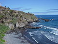
The "Sendero del Agua", or "Water Footpath", on the coast of Los Realejos, in the north of Tenerife, runs through one of the most beautiful spots on the entire island: the Rambla de Castro Protected Landscape. The path begins at the San Pedro Panoramic Viewing Point, just beside the northern dual carriageway, at kilometre 41.5. The first thing the amazed visitor will see is Rambla del Mar and Rambla de Babón where the green of the banana plantations is contrasted with the blue of the waters of the Atlantic.
The path brings us to Rambla de Castro, a former entailed estate, which was an obligatory visit for travellers and scientists of the 19th Century. Here we can appreciate one of the most beautiful palm groves on the island of Tenerife and twohistorical buildings, the Hacienda de los Castro and the Fortín de San Fernando, where three of the five cannon in its battery still survive.
Continuing in a direction from West to East, when we arrive at the Godinez Ravine, the path offers us two alternatives: to go down to La Fajana beach, or to undertake the steep slope that will take us to la Romántica I to take a look at the ruins of the Gordejuela Water Elevator, built in1903 by the Hamilton Company, an installation which was a landmark of its time due to the complicated contours of the terrain and because this was the first steam engine on the island of Tenerife.
After leaving la Gordejuela behind us, the path leads us on to la Romántica II. After crossing the streets of Las Palmeras and Las Amapolas, we take the pathway again to Los Roques bay, a place of astounding beauty where two enormous rocks, created by the erosive power of the sea, break the surface.
There are other highly attractive spots along the course of this footpath which intrepid walkers can discover for themselves.
THE TIGAIGA FOOTPATH
The Cordillera de Tigaiga is one of the principal ecosystems on the island of Tenerife. The abundance of life it contains has caused the Canarian authorities to give it various kinds of special protection and has led the European Union to declare it an Area of Special Protection for Birds.
Exuberant plant life and splendid views of the Orotava Valley and the north-east of the island will fill the senses of any walkers who decide to cover the almost ten kilometres separating Madre Juana from Portillo de la Villa, almost at the foot of Mount Teide.
At the Caserio de Madre Juana, there begins a steep slope surrounded by heather and myrtle, which leads to the La Corona panoramic viewing point. From here we have to follow the path that leads down the Ladera de Tigaiga, so as to enjoy the dense laurel woodland and a pinewood which until only a few years ago was a delight for lovers of mushrooms.
Once we leave the pinewood and the magnificent facilities of the Emilio Fernández Múñoz Nature Classroom behind us, this terrain of high mountain shrubland will take us to Cruz de Fregel, from where we can see in all its immensity the la Degollada plain and Mount Teide. As we descend the Cruz de Fregel, we shall bear left onto a quiet and peaceful path which will take us, in no more than half an hour, to the Visitors' Centre of the National Park. Lovers of flora and fauna should not forget to take a good reference book in view of the large numbers of native species you will see along the way.
Panoramic viewing points
On the Ladera de Tigaiga is the La Corona Viewing Point, a visit not to be missed. It is possible to get here from the village of Icod el Alto as the road is metalled. From this incomparable setting, there is a breathtaking panoramic view of the famous Orotava Valley in all its immensity and of the entire north-east of the island. This is also a privileged spot for lovers of adventure sports such as para-gliding.
A little further down, on the access road to Icod el Alto, is the El Lance Panoramic Viewing Point, the mythical location from which the native prince, Mencey Bentor, leapt into the abyss, preferring death rather than slavery and humiliation at the hands of the cruel conquistador. Thanks to the Plan for Excellence in Tourism, there is a spacious recreational area.
On the coast, in the vicinity of the village of San Vicente, is the San Pedro Viewing Point, from which you can see the exuberant palm grove at La Rambla de Castro and the green of the banana plantations at la Rambla del Mar, surrounding houses with brilliant white walls and beautiful roofs, which give the landscape a harmony in the contrasting colours which is unlike anywhere else in the district.
On the northern dual carriageway, once you have passed the Socorro beach and the tunnel of Barranco de la Torre, you come to La Grimona Viewing Point, with a vista of the beach of the same name, and the coast at el Socorro and Guindaste Point.
Histocal and artistic heritage
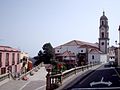
The district of Los Realejos at one time possessed a historical and artistic heritage of some significance, the result of its economic wealth and that it was chosen as a place of residence by merchants, of the activities of religious orders and the Church itself. However, hardly any evidence of this glorious past now remains owing to the continual fires which destroyed interesting groups of buildings constructed during the 17th and 18th Centuries - the Monastery of St John the Baptist (Augustinian) 1806; the Monastery of Santa Lucia (Franciscan), 1865; the Monastery of San Andrés and Santa Mónica (Augustinian), 1952; the Church of Our Lady of the Immaculate Conception, 1978.
At present, the historical and artistic heritage of Los Realejos comprises especially the churches, outstanding among which are that of St James the Apostle, the first to be built on the island of Tenerife (1496) and declared a National Historical Monument, and that of the Immaculate Conception. There are too the chapels and haciendas, many of which are to be found along the coastal strip, known as the Ramblas del Mar, de Babón and de Castro.
The Viticulture
Los Realejos is regarded as the "cathedral of white wine". The wines prepared in this district and indeed the whole of the Orotava Valley have enjoyed well-deserved fame throughout their history. In the 17th and 18th Centuries this was the principal wine-growing district of the Canaries. The wines were exported to England and its colonies, to Germany, Holland and to Latin America. The vineyards were so extensive that the illustrious son of Los Realejos, Viera y Clavijo, was moved to write that the entire valley was one immense tapestry of vines.
The Orotava Valley is one of the most important areas of the Canary Islands for its long-standing wine-making tradition and wine production. In this ancient valley, which lies between Mount Teide and the cool waters of the Atlantic Ocean, there are still numerous vineyards, to be found on terraces throughout the district from La Orotava to Los Realejos.
The Regulatory Council for the local wines has since its creation spared no effort to put the wines of the Orotava Valley back in their rightful place in view of their historical tradition and their quality, to defend the wine growers and merchants by conferring the right to use a label which guarantees the origin and quality of the produce of this area to the consumer.
The Local Bulk Wine and the Regional Bottled White Wine Competitions are held in May, and enjoy official recognition from the Ministry of Agriculture.
-
 Iglesia de Nuestra Señora de la Concepción
 -

-
 Water elevator
 -
 Playa de Castro


Historical population
| Year | Population | Change |
|---|---|---|
| 1991 | 29,829 | - |
| 1996 | 32,599 | |
| 2001 | 33,438 | 586.63/km² |
| 2002 | 35,299 | - |
| 2003 | 35,799 | 627.17/km² |
| 2004 | 35,756 | 618.83/km² |
| 2009 | 37,559 | 650.00/km² |
Until 2004, the population trend was slowly booming before it went to a small decline.
Natives of Los Realejos
- José Viera y Clavijo (December 28, 1731, Las Palmas de Gran Canaria - February 21, 1813), a writer, botanist and a historian.
Other
Los Realejos has schools, a few lyceums, a gymnasia, churches, a post office and a few squares plazas. It is also the home of English language newspaper the Tenerife News.
- Map and aerial photos
- Street map: Street map from Mapquest, MapPoint or Google
- Satellite images: Google
- Coordinates: 28°21′0″N 16°36′0″W / 28.35000°N 16.60000°W
See also
External links
- Official web site with information about Los Realejos
- Franciscana Cofradía del Nazareno
- Picas Album Web from Franciscana Cofradía del Nazareno
| North: Atlantic Ocean | Northeast: Puerto de la Cruz | |
| West: San Juan de la Rambla | Los Realejos | East: La Orotava |
| South: La Orotava |