Sidgwick Site: Difference between revisions
Sidgwicknut (talk | contribs) No edit summary |
Sidgwicknut (talk | contribs) No edit summary |
||
| Line 7: | Line 7: | ||
The site as it is now has its origins in plans drawn up by [[Casson and Conder]] in 1952 for making use of land to the west of the Cambridge city centre which was previously used mainly for sports. Much of the site's current architecture derives from these original plans. However, many faculty buildings, especially to the north of the site, have been designed by separate architects with little reference to the coherence of the site as a whole. In July 2002, the old [[Faculty of English, Cambridge|Faculty of English]], a converted [[Victorian architecture|Victorian]] villa, was demolished, and a more practical building designed by [[Allies and Morrison]] to reflect the needs of the faculty was completed in 2004. |
The site as it is now has its origins in plans drawn up by [[Casson and Conder]] in 1952 for making use of land to the west of the Cambridge city centre which was previously used mainly for sports. Much of the site's current architecture derives from these original plans. However, many faculty buildings, especially to the north of the site, have been designed by separate architects with little reference to the coherence of the site as a whole. In July 2002, the old [[Faculty of English, Cambridge|Faculty of English]], a converted [[Victorian architecture|Victorian]] villa, was demolished, and a more practical building designed by [[Allies and Morrison]] to reflect the needs of the faculty was completed in 2004. |
||
On 29 October 2006, [[Education Not For Sale]] supporters at Cambridge University organised the first occupation in the UK in protest at the introduction of top-up fees on the Sidgwick Site Lecture Hall, occupying it for 12 hours. |
On 29 October 2006, [[Education Not For Sale]] supporters at Cambridge University organised the first occupation in the UK in protest at the introduction of top-up fees on the Sidgwick Site Lecture Hall, occupying it for 12 hours.<ref>http://www.cambridge-news.co.uk/cn_news_home/DisplayArticle.asp?ID=384366</ref> |
||
==Faculties on the Sidgwick Site== |
==Faculties on the Sidgwick Site== |
||
Revision as of 23:24, 28 February 2010


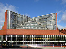
The Sidgwick Site is one of the largest sites within the University of Cambridge, England.[1][2] It is located on the western edge of Cambridge city centre, north of Sidgwick Avenue and south of West Road, and is home to several of the university's arts faculties. The site is named after the philosopher Henry Sidgwick, who studied at Cambridge in the 19th century.
The site as it is now has its origins in plans drawn up by Casson and Conder in 1952 for making use of land to the west of the Cambridge city centre which was previously used mainly for sports. Much of the site's current architecture derives from these original plans. However, many faculty buildings, especially to the north of the site, have been designed by separate architects with little reference to the coherence of the site as a whole. In July 2002, the old Faculty of English, a converted Victorian villa, was demolished, and a more practical building designed by Allies and Morrison to reflect the needs of the faculty was completed in 2004.
On 29 October 2006, Education Not For Sale supporters at Cambridge University organised the first occupation in the UK in protest at the introduction of top-up fees on the Sidgwick Site Lecture Hall, occupying it for 12 hours.[3]
Faculties on the Sidgwick Site
- Faculty of English, including Anglo-Saxon Norse and Celtic
- Faculty of Music
- Faculty of History
- Faculty of Law
- Faculty of Linguistics
- Faculty of Modern & Medieval Languages
- Faculty of Economics
- Faculty of Oriental Studies
- Faculty of Classics
- Faculty of Divinity
- Faculty of Philosophy
- Institute of Criminology
The Department of Land Economy is planned to move to the Sidgwick Site in the future.
