Iłża: Difference between revisions
Appearance
Content deleted Content added
m copyedit, MOS and or AWB general fixes using AWB |
SlavPoland (talk | contribs) |
||
| Line 44: | Line 44: | ||
{{coord|51|10|N|21|15|E|region:PL_type:city|display=title}} |
{{coord|51|10|N|21|15|E|region:PL_type:city|display=title}} |
||
== |
==External links== |
||
* [http://www.sztetl.org.pl/en/city/ilza/ Jewish Community in Iłża] on Virtual Shtetl |
|||
{{reflist}} |
|||
<br> |
<br> |
||
Revision as of 13:03, 24 March 2012
Iłża | |
|---|---|
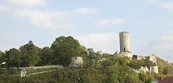
 Iłża castle | |
| Country | |
| Voivodeship | Masovian |
| County | Radom |
| Gmina | Iłża |
| Town rights | 1239 |
| Government | |
| • Mayor | Andrzej Moskwa |
| Area | |
| • Total | 15.83 km2 (6.11 sq mi) |
| Population (2006) | |
| • Total | 5,165 |
| • Density | 330/km2 (850/sq mi) |
| Time zone | UTC+1 (CET) |
| • Summer (DST) | UTC+2 (CEST) |
| Postal code | 27-100 |
| Area code | +48 48 |
| Car plates | WRA |
| Website | http://www.ilza.pl/ |

Iłża [ˈiu̯ʐa] is a small town in Masovian Voivodeship, Poland. It is located at around 51°10′0″N 21°15′0″E / 51.16667°N 21.25000°E. The Iłżanka River flows through the town. In 2004 Ilza had 5178 inhabitants. Attractions: - remains of the castle built in 1340 by bishop Jan Grot - the church dating back to 1326, nowadays baroque - Jewish cemetery from 19th century.
51°10′N 21°15′E / 51.167°N 21.250°E
External links
- Jewish Community in Iłża on Virtual Shtetl


