Józefów: Difference between revisions
Appearance
Content deleted Content added
m Resolve redirect, per WP:TFD |
SlavPoland (talk | contribs) |
||
| Line 45: | Line 45: | ||
{{commonscat|Józefów (powiat otwocki)}} |
{{commonscat|Józefów (powiat otwocki)}} |
||
* [http://www.jozefow.pl/WWW/index.html The official webpage of Józefów] |
* [http://www.jozefow.pl/WWW/index.html The official webpage of Józefów] |
||
* [http://www.sztetl.org.pl/en/city/jozefow/ Jewish Community in Józefów] on Virtual Shtetl |
|||
{{coord|52|08|N|21|14|E|region:PL_type:city|display=title}} |
{{coord|52|08|N|21|14|E|region:PL_type:city|display=title}} |
||
Revision as of 13:05, 24 March 2012
Józefów | |
|---|---|
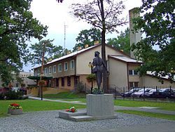
 Town center | |
| Country | |
| Voivodeship | Masovian |
| County | Otwock |
| Gmina | Józefów (urban gmina) |
| Town rights | 1962 |
| Government | |
| • Mayor | Stanisław Kruszewski |
| Area | |
• Total | 23.92 km2 (9.24 sq mi) |
| Elevation | 94 m (308 ft) |
| Population (2006) | |
• Total | 18,353 |
| • Density | 770/km2 (2,000/sq mi) |
| Time zone | UTC+1 (CET) |
| • Summer (DST) | UTC+2 (CEST) |
| Postal code | 05-420, 05-410 |
| Area code | +48 22 |
| Car plates | WOT |
| Website | http://jozefow.pl |
Józefów [juˈzɛfuf] is a town in Poland, located in Masovian Voivodeship, in Otwock County. It lies about 15 km southeast of downtown Warsaw and is a part of that city's metropolitan area. Located on a picturesque confluence of Vistula and Świder rivers, it is home to one landscape reserve and three natural reservation zones. As of 2006[update] it had 18,157 inhabitants.
External links
Wikimedia Commons has media related to Józefów (powiat otwocki).
- The official webpage of Józefów
- Jewish Community in Józefów on Virtual Shtetl
52°08′N 21°14′E / 52.133°N 21.233°E


