
Gariep Dam: Difference between revisions
→References: remove interwiki links moved to Wikidata Tag: Removal of all interwiki links; Wikidata is live |
Kt75 mirror (talk | contribs) mNo edit summary |
||
| Line 8: | Line 8: | ||
|locale=border [[Eastern Cape]] and [[Free State (South African province)|Free State]], [[South Africa]] |
|locale=border [[Eastern Cape]] and [[Free State (South African province)|Free State]], [[South Africa]] |
||
|maint= Department of Water Affairs and Forestry |
|maint= Department of Water Affairs and Forestry |
||
|length= |
|length= 884m |
||
|height= |
|height= 73m |
||
|type= Double Curvature Concrete Arch |
|||
|width= |
|width= |
||
|began= |
|began= |
||
| Line 16: | Line 17: | ||
|cost= |
|cost= |
||
|reservoir_capacity={{convert|5340000|ML|hm3}}<ref>{{cite web|url=http://www.dwaf.gov.za/hydrology/applets/weekly/deltaweekly.asp|title=State of Dams in Provinces as on 20080901|publisher=Department of Water Affairs and Forestry|accessdate=2008-09-07}}</ref> |
|reservoir_capacity={{convert|5340000|ML|hm3}}<ref>{{cite web|url=http://www.dwaf.gov.za/hydrology/applets/weekly/deltaweekly.asp|title=State of Dams in Provinces as on 20080901|publisher=Department of Water Affairs and Forestry|accessdate=2008-09-07}}</ref> |
||
| reservoir_surface = |
| reservoir_surface = 352.16 km² |
||
| turbines = 4 |
| turbines = 4 |
||
| installed_capacity = 90 MW each |
| installed_capacity = 90 MW each |
||
| Line 80: | Line 81: | ||
==References== |
==References== |
||
*[http://kt75-mirror.blogspot.ch/p/kt75-interactive.html _sustinvent+] from the [http://kt75-mirror.blogspot.ch _kt75 mirror] |
|||
{{reflist}} |
{{reflist}} |
||
Revision as of 08:00, 25 February 2013
| Gariep Dam | |
|---|---|
 | |
| Coordinates | 30°37′25.43″S 25°30′23.81″E / 30.6237306°S 25.5066139°E |
 Gariep Dam | |
Gariep Dam is a dam in South Africa, near the town of Norvalspont, Free State province, South Africa.
Name
The Gariep Dam was originally named the Hendrik Verwoerd Dam after the first Prime Minister of the Republic of South Africa Hendrik Frensch Verwoerd on its commission in 1971. However after the end of apartheid the name was considered unsuitable, and the name was officially changed to Gariep Dam on 4 October 1996. Gariep is San for "Great water", and is the original name of the Orange River.
Location
The dam is located on the Orange River between the Eastern Cape to the south and the Free State to the north and about 30 km north east of Colesberg. It is situated in a gorge at the entrance to the Ruigte Valley some 5 km east of Norvalspont.
Dimensions
The wall is 88 m high and has a crest length of 914 m and contains approximately 1.73 million m³ of concrete. The Gariep Dam is the largest storage reservoir in South Africa. In South African English, dam refers both to the structure and the lake it impounds. Gariep Dam has a total storage capacity of approximately 5,340,000 megalitres (5,340 hm3) and a surface area of more than 370 square kilometres (140 sq mi) when full. The hydro-electrical power station houses four 90 MW generators, giving a maximum output of 360 MW of electricity at a water flow rate of 800 m³/s.
Design type and contractors
The dam itself is a concrete gravity-arch hybrid dam. This design was chosen as the gorge is too wide for a complete arch so flanking walls form gravity abutments to the central arch. The dam was built by Dumez, a French construction company.[2]
Rivers/spruits flowing into the dam[3]
Orange-Fish River Project
At Oviston, on the south bank of the reservoir, is the inlet of the Orange-Fish River Tunnel, allowing water to be diverted to the Great Fish River and the Eastern Cape.
Gallery
-
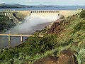 Gariep Dam overflowing in January 2011
 -
 Sunset at Oviston Nature Reserve on the dam's southern shores
 -
 Road sign heading for the dam wall
 -
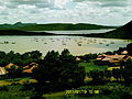
 View over the lake
 -
 Forever Holiday Resort at Gariep Dam


.JPG)
.JPG)
.JPG)
See also
- Oviston Nature Reserve, located on the southern side of the reservoir
- Orange River
- Eskom
- List of rivers of South Africa
- List of reservoirs and dams in South Africa
References
- _sustinvent+ from the _kt75 mirror
- ^ "State of Dams in Provinces as on 20080901". Department of Water Affairs and Forestry. Retrieved 2008-09-07.
- ^ Vinci website: Hendrik Verwoerd Dam
- ^ http://www.dwaf.gov.za/iwqs/gis_apps/dam/dams/gariep.htm