
Great Wagon Road: Difference between revisions
Added VA-654 shortcut from Cloverdale to Lynchburg in Remark. |
Added tabular information from Roanoke to North Carolina Border. |
||
| Line 232: | Line 232: | ||
| || || Williamson Rd || 0.8 || || |
| || || Williamson Rd || 0.8 || || |
||
|- |
|- |
||
| Roanoke, Virginia (Estab. 1834 as "Big Lick") || || || || || In 1753, the original 15 Moravian men on their way to start a settlement at Wachovia (present-day Winston-Salem), North Carolina, were apparently misinformed and took a wrong turn here. With great effort, they forced their way with a large Conestoga type of wagon through the [[Windy Gap]] packhorse road over the Blue Ridge mountains (now VA-116). After their descent into Franklin County on the east side of the ridge and following VA-684, they rejoined the Great Wagon Road at Boone's Mill, Virginia.{{sfn|Jacobs|1912}}{{sfn|Mereness|1916|page=345-347}} |
|||
| Roanoke, Virginia (Estab. 1834 as "Big Lick") || || || || || {{sfn|Jacobs|1912}} |
|||
|- |
|- |
||
| || || Franklin Rd || 1.4 || || |
| || || Franklin Rd || 1.4 || || {{sfn|map|1865}} |
||
|- |
|- |
||
| Roanoke River Ford (now a bridge) || || || || || Franklin Rd (US-220Bus) continues onward, becoming Electric Rd (VA-419), which forks south after 1 |
| Roanoke River Ford (now a bridge) || || || || || Franklin Rd (US-220Bus) continues onward, becoming Electric Rd (VA-419), which forks south after 1 mile to Starkey Rd (VA-604) leading to Merriman Rd (VA-613). VA-613 leaves the Great Valley, crossing into Franklin County through [[Maggoty Gap]] in the Blue Ridge mountains; this route provided wagon access to North and South Carolina and Georgia. |
||
|- |
|||
| || US-220Business || Franklin Rd || 2 || || {{sfn|map|1865}} |
|||
|- |
|||
| US-220 Freeway Intersection || || || || || |
|||
|- |
|||
| || VA-419 || Electric Rd || 1 || || {{sfn|map|1865}} |
|||
|- |
|||
| || VA-604 || Starkey Rd || 2 || || {{sfn|map|1865}} |
|||
|- |
|||
| || VA-613 || Merriman Rd || 2.5 || || {{sfn|map|1865}} |
|||
|- |
|||
| Simmonds Gap (Formerly [[Maggoty Gap]]; Franklin County Line || || || || || {{sfn|map|1865}} |
|||
|- |
|||
| || VA-613 || Naff Rd || 4.5 || || |
|||
|- |
|||
| US-220 Freeway Intersection || || || || || |
|||
|- |
|||
| || US-220 || Goode Hwy || 1 || || |
|||
|- |
|||
| Boone's Mill, Virginia (Estab. 1786) || || || || || After 1838, the Great Wagon Road moved to the Franklin-Fincastle turnpike, which continued straight here and passed through Rocky Mount, Virginia.{{sfn|Mitchell|2003}}{{sfn|Clement|1952}} |
|||
|- |
|||
| || VA-739 || Bethlehem Rd || 5 || || Passing over Little Creek culvert. The original Moravian Settlers of Wachovia camped here on Bethlehem Road at Little Creek on November 4, 1753.{{sfn|Mereness|1916|page=347}} |
|||
|- |
|||
| || VA-643 || Bethlehem Rd || 2.5 || || |
|||
|- |
|||
| || VA-641 || Calloway Rd || 0.2 || || Detour around a cultivated field. (Calloway Post Office is 3.5 miles west of here.) |
|||
|- |
|||
| || VA-643 || Hickman/Hopkins Rd || 2.2 || || |
|||
|- |
|||
| Blackwater River Ford (now a one-lane bridge) || || || || || |
|||
|- |
|||
| || VA-643 || Coles Creek Rd || 2.8 || || Passing over Coles Creek culvert. |
|||
|- |
|||
| || VA-821 || Calico Rock Rd || 1.6 || || |
|||
|- |
|||
| Crossing of VA-640 (6 Mile Post Rd) || || || || || |
|||
|- |
|||
| || VA-980 || Pepper Rd || 0.1 || || Staying on northeast side of creek. |
|||
|- |
|||
| || || Dirt Track || 0.7 || || Around cultivated fields. (May be passable now only on foot or bike.) A detour is located 3 miles west of here; south on VA-756 (Old Forge Rd). |
|||
|- |
|||
| Pigg Creek Ford || || || || || This ford is directly at the north end of VA-802. |
|||
|- |
|||
| || VA-802 || Old Carolina Rd || 0.8 || || (Another path of the "Old Carolina Rd" appears to run along the ridge just 0.3 mile southeast of this path.) |
|||
|- |
|||
| || VA-756 || Old Forge Rd || 0.1 || || |
|||
|- |
|||
| || VA-864 || Old Ferrum Rd || 7 || || The original Moravian Settlers of Wachovia camped here beside Story Creek one mile northeast of Ferrum on November 5, 1753.{{sfn|Mereness|1916|page=348}} |
|||
|- |
|||
| || VA-623 || Union Rd + Ingramville Rd || 0.5 || || Passing over Story Creek culvert. |
|||
|- |
|||
| Ferrum, Virginia (Estab. 1889) || || || || || Railroad crossing here. The Great Wagon Road south of here was obliterated by railroad construction in 1892. |
|||
|- |
|||
| || VA-767 || Prillamin Switch Rd || 6 || || Passing over Little Town Creek & Town Creek culverts. |
|||
|- |
|||
| || VA-606 || Town Creek Dr || 2.5 || || Passing over Town Creek Fork bridge. Later travelers could avoid some of the swamps along Town Creek by following ridges west of the valley; VA-771 (Will Hill Rd) and VA-770 (Old Henry Rd). |
|||
|- |
|||
| Henry, Virginia (Estab. 1790); Town Creek Ford (now a bridge); Henry County Line (Estab. 1777) || || || || || The original Moravian Settlers of Wachovia camped here November 6, 1753.{{sfn|Mereness|1916|page=348,349}} |
|||
|- |
|||
| || VA-606 || Henry Fork Rd + Original Henry Rd || 4 || || Passing over Town Creek and Grassy Creek swampy area. |
|||
|- |
|||
| || VA-606 || Philpott Dr + Oak Level Rd || 4 || || Long gradual ascent, then one mile along the ridge. |
|||
|- |
|||
| || VA-669 || Colonial Hill Rd || 0.6 || || Steep descent, crossing Little Reed Creek at bottom. |
|||
|- |
|||
| || US-220 || Virginia Ave || 1 || || The original Wachovia settlers described this section as "beautiful lowlands" with many grapes, which they enjoyed. They camped on November 7, 1753 at the mouth of Reed Creek on the bank of Smith River. The landscape as seen by them has since been extensively altered; the Philpott dam upstream has reduced the river to a relative trickle and the construction of a railroad and major highway interchange further modified the topography. For these reasons it is difficult to interpret their diary notes. It seems clear, however, that although the next day was extremely strenuous, they traveled through Collinsville, Virginia, and ended up at the mouth of Daniels Creek on the bank of Smith River, across from present-day Fieldale, Virginia.{{sfn|Mereness|1916|page=349}} |
|||
|- |
|||
| Smith River Ford; Fieldale, Virginia (Estab. 1917) || || || || || The original Wachovia settlers camped on the east bank of the Smith River ford here on November 8th, 9th, and 10th, 1753, waiting for the floodwater to recede. The next day, after fording the river, they took a very difficult route straight ahead through a swamp and up a rough hillside to rejoin the Great Wagon Road.{{sfn|Mereness|1916|page=349-351}} |
|||
|- |
|||
| Fork in The Great Wagon Road at Smith River || || || || || Later traffic across this ford appeared to take a right turn onto the Great Wagon Road which looped north briefly around the rough hills. It also appears that wagon traffic in better weather used a ford almost at the mouth of Blackberry Creek (at the end of VA-698) instead of at Fieldale. The 1751 Frye-Jefferson map shows the Blackberry Creek location.{{sfn|Fry, Joshua|1751}} |
|||
|- |
|||
|- |
|||
| || VA-609 || Dillons Fork Rd || 2.5 || || A man named John Hickey had a peddler's license and ran a store and "ordinary" here at Rangely, Virginia in 1753. It was the last place to buy salt until beyond Winston-Salem, North Carolina.{{sfn|Mereness|1916|page=351}} |
|||
|- |
|||
| || VA-683 || The Great Rd + Meadowood Trail || 4.5 || || In 1753, the original Wachovia settlers continued south along VA-683 (fording over Jordan Creek and Bassett Branch) to Preston Rd. Other travelers reportedly turned west onto VA-627 (Hodges Farm Rd) for 2 miles and then south on VA-687 (Preston Rd) to avoid creeks and swamps.{{sfn|Mereness|1916|page=351}} |
|||
|- |
|||
| || VA-687 || Preston Rd || 5.5 || || |
|||
|- |
|||
| || US-58 || Philpott Hwy || 0.3 || || |
|||
|- |
|||
| Horse Pasture, Virginia; Crossing of US-58 (Philpott Hwy) || || || || || The original Wachovia settlers camped here on November 11, 1753.{{sfn|Mereness|1916|page=351,352}} |
|||
|- |
|||
| || VA-694 || Wagon Trail Rd || 3.5 || || |
|||
|- |
|||
| || VA-692 || Horsepasture-Price Rd || 0.2 || || |
|||
|- |
|||
| || VA-692 || Wagon Trail Rd || 3.3 || || Passing over Horse Pasture Creek ford (now a culvert). |
|||
|- |
|||
| || VA-695 || George Taylor Rd || 1.4 || || |
|||
|- |
|||
| North Mayo River Ford (now a bridge) || || || || || |
|||
|- |
|||
| || VA-695 || George Taylor Rd || 3.6 || || |
|||
|- |
|||
| South Mayo River Ford (now a bridge) || || || || || The original Wachovia settlers camped here on November 12, 1753.{{sfn|Mereness|1916|page=352}} |
|||
|- |
|||
| || VA-695 || George Taylor Rd || 1.2 || || |
|||
|- |
|||
| Crooked Creek Ford (now a bridge) || || || || || |
|||
|- |
|||
| || VA-695 || George Taylor Rd || 0.4 || || |
|||
|- |
|||
| North Carolina State Line; Stokes County Line || || || || || |
|||
|} |
|} |
||
| Line 274: | Line 376: | ||
* {{cite book | last=Smith | first=Byron C. (Curator) | title=Beginnings 1732-1783; Town History | publisher=Newtown History Center; Stone House Foundation | date=2014}} http://www.newtownhistorycenter.org/beginnings.php - Accessed 8/3/14. |
* {{cite book | last=Smith | first=Byron C. (Curator) | title=Beginnings 1732-1783; Town History | publisher=Newtown History Center; Stone House Foundation | date=2014}} http://www.newtownhistorycenter.org/beginnings.php - Accessed 8/3/14. |
||
* {{cite book | last=Bridenbaugh | first=Carl | title=Myths & Realities: Societies of the Colonial South | publisher=Lousiana State University Press | date=1952}} |
* {{cite book | last=Bridenbaugh | first=Carl | title=Myths & Realities: Societies of the Colonial South | publisher=Lousiana State University Press | date=1952}} |
||
* {{cite book | last=Jacobs | first=Edward B. | title=History of Roanoke City | publisher=Stone Printing & Mfg., Roanoke, Virginia | date=1912}} |
* {{cite book | last=Jacobs | first=Edward B. | title=History of Roanoke City | publisher=Stone Printing & Mfg., Roanoke, Virginia | date=1912}} cf. G. S. Jack, "History of Roanoke County", 1912, p.92. |
||
* {{cite book | last=Map| title=Map of Roanoke County, Virginia, c.1865 | publisher=Library of Congress, Call Number G3883.R5 186- .R5 Vault : Hotch 56 | date=1865}} http://hdl.loc.gov/loc.gmd/g3883r.cwh00056 - Accessed 8/8/2014. |
* {{cite book | last=Map| title=Map of Roanoke County, Virginia, c.1865 | publisher=Library of Congress, Call Number G3883.R5 186- .R5 Vault : Hotch 56 | date=1865}} http://hdl.loc.gov/loc.gmd/g3883r.cwh00056 - Accessed 8/8/2014. |
||
* {{cite book | last=Clement| first=Maude C. | title=An Abbreviated History of Pittsylvania County, Virginia, Chapter Five: Transportation and Routes | publisher=Victorianvilla.com | date=1952}} http://www.victorianvilla.com/sims-mitchell/local/clement/mc/abb/05.htm - Accessed 8/11/2014. |
|||
* {{cite book | last=Mitchell | first=Betty Naff | title=A Little History of Boones Mill | date=2003}} http://naff.bravepages.com/boones_mill.html - Accessed 8/13/2014. |
|||
{{refend}} |
{{refend}} |
||
Revision as of 07:38, 14 August 2014

The Great Wagon Road was a colonial American improved trail transiting the Great Appalachian Valley from Pennsylvania to North Carolina, and from there to Georgia.
Introduction
The Great Wagon Road was the heavily traveled main route for settlement of the Southern United States, particularly the "backcountry". Although a wide variety of settlers traveled southward on the road, two dominant cultures emerged. The German Palatines and Scotch-Irish American immigrants arrived in huge numbers because of unendurable conditions in Europe. The Germans (also known as Pennsylvania Dutch) tended to find rich farmland and work it zealously to become stable and prosperous. The other group (known also as Presbyterian or Ulster Scots) tended to be restless, clannish, and fiercely independent; they formed what became known as the Appalachian Culture. Partly because of the language difference, the two groups tended to keep to themselves.[1][2][3]
Beginning at the port of Philadelphia, where many immigrants entered the colonies, the Great Wagon Road passed through the towns of Lancaster and York in southeastern Pennsylvania.
Turning southwest, the road crossed the Potomac River and entered the Shenandoah Valley at Winchester, Virginia, continuing south in the valley via the Great Warriors' Trail (also called the Indian Road, as on this map), which was established by centuries of Indian travel. The Treaty of Lancaster of 1744 had established colonists' rights to settle along the Indian Road. The Shenandoah portion of the road is also known as the Valley Pike.

South of the Shenandoah Valley, the road reached the Roanoke River at the town of Big Lick (today, Roanoke). South of Roanoke, the Great Wagon Road was also called the Carolina Road. At Roanoke, a road forked southwest, leading into the upper New River Valley and on to the Holston River in the upper Tennessee Valley. From there, the Wilderness Road led into Kentucky.
From Big Lick/Roanoke, after 1748, the Great Wagon Road passed through the Maggoty Gap (also called Maggodee) to the east side of the Blue Ridge Mountains. Continuing south through the Piedmont region, it passed through the present-day North Carolina towns of Winston-Salem, Salisbury, and Charlotte and sites of earlier Indian settlements on the historic Indian Trading Path. The Great Wagon Road ultimately reached Augusta, Georgia on the Savannah River.
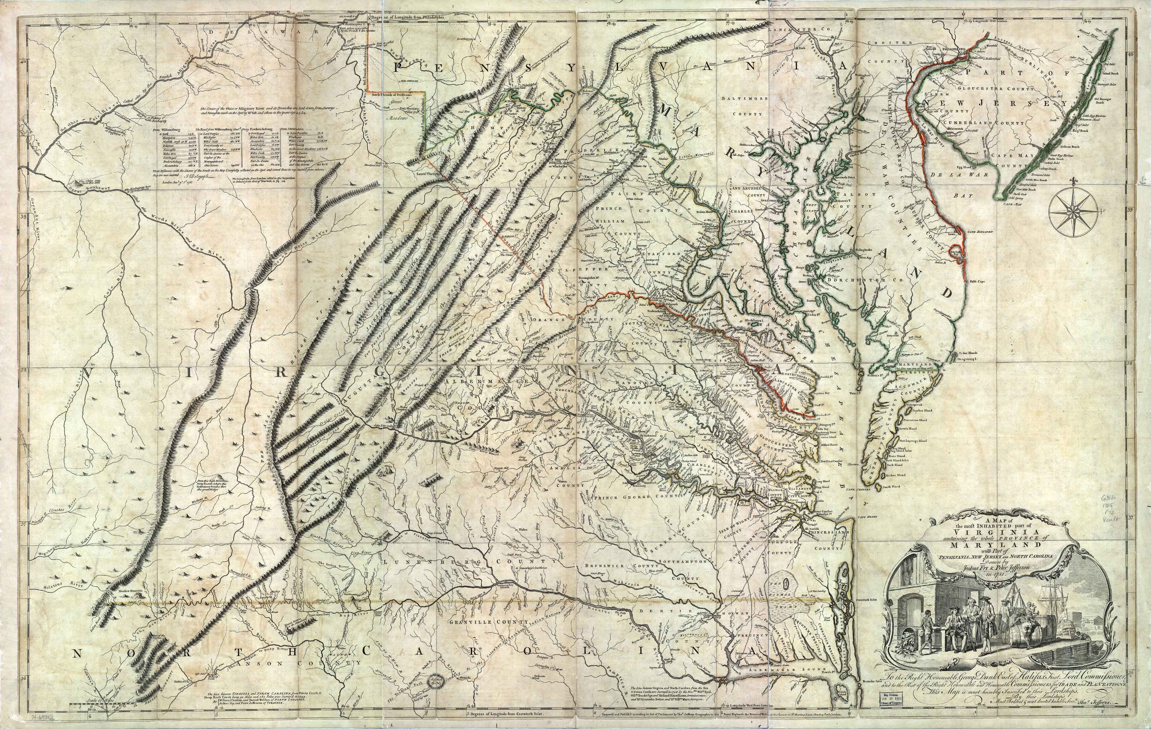
Despite its current name, the southern part of this road was by no means passable by wagons until later Colonial times. The 1751 Fry-Jefferson map on this page notes the term 'Waggon' only north of Winchester. In 1753, wagon travelers reported that "the good road ended at Augusta" (now Staunton, Virginia), although they did keep going all the way to Winston-Salem.
Great Wagon Road Segments (Circa 1754)
Note: The segments are approximations; actual paths varied constantly with fallen trees, floods, etc. All distances are approximate.
Begin at Philadelphia, Pennsylvania:
| Location | Present-Day Road Segment Number | Present-Day . Road Segment Name | Distance Covered (Miles) | Distance Covered (km) | Remarks |
|---|---|---|---|---|---|
| Philadelphia, Market Street, at Delaware River | |||||
| State Road 3 (PA-3) | Market St | By about 1740, milestones were placed along the side of the Great Wagon Road to Lancaster (known as the "King's Road", or occasionally the "Conestoga Road"), each with a chiseled number, indicating the distance in miles from the Quaker meeting house at Second Street and High Street (now Market Street) in Philadelphia. (Example: "20 M to P")[4] | |||
| Schuylkill River Ferry (now a bridge) | |||||
| PA-3 | Market St | 0.7 | The Strasburg Road (built 1790) branched here, (continuing along PA-3, PA-162, PA-372, PA-741) through West Chester, Parkesburg, Gap, and Strasburg, Pennsylvania, from where a track continued through Willow Street village to the Susquehanna River at the mouth of the Conestoga River. This road followed roughly the ancient Great Minquas Path, also known occasionally as the Conestoga Path.[5] | ||
| PA-3005 | Lancaster Ave | 2 | Detour around Drexel University (founded 1891). This is where the 1795 Philadelphia and Lancaster Turnpike began. | ||
| Crossing of Girard Ave, Philadelphia | |||||
| US-30 | Lancaster Ave | 2.4 | |||
| Montgomery County Line; at US-1 (City Ave) | The Lincoln Highway (1916) from Trenton, New Jersey (US-1) joined the Lancaster Turnpike (1790) here.[6] | ||||
| US-30 | Lincoln Hwy | 10 | This section (Old Lancaster Road) was relocated in many places in 1830 by construction of the Pennsylvania Railroad "Main Line". | ||
| Delaware County Line; at County Line Rd | |||||
| US-30 | Lincoln Hwy | 9 | |||
| Chester County Line; at Sugartown Rd | |||||
| US-30 | Lancaster Ave | 11 | |||
| Crossing of US-202 | |||||
| US-30 Business Route | Lincoln Hwy | 7 | |||
| Downingtown (formerly Milltown), Pennsylvania; Brandywine Creek Ford (now a bridge) | The Philadelphia and Lancaster Turnpike (built 1795) branched here, continuing along US-30Business until rejoining US-30 twelve miles west of here. US-30 now follows its path until meeting PA-462 at Lancaster. The turnpike continued along PA-462 to end at the Susquehanna River in Columbia, Pennsylvania.[4] After 1913, the turnpike was renamed as a section of "The Lincoln Highway".[6] | ||||
| US-322 | Manor Ave | 3 | In 1803, the Horseshoe Pike (now US-322) was built from here to Ephrata and Harrisburg, Pennsylvania.[7] | ||
| PA-4015 | Edges Mill Rd | 1.7 | |||
| PA-340 | Kings Road | 12 | The King's Road was built from Philadelphia to Lancaster in 1733.[8] It became a section of the Great Wagon Road. | ||
| PA-340 | Old Philadelphia Pike | 10 | PA-340 departs from the original Harrisburg Road at White Horse, Pennsylvania. Called Old Peter's Road (for Peter Bezaillon, who had a trading post at the end of the road), this packhorse road turned northwest through Springville, Groffdale, and Center Square, then over a future quarry to ford the Conestoga River, continuing south of Lancaster Airport to Mount Joy, then along Donegal Springs Road and Stackstown Road to the Susquehanna River at Bainbridge (formerly Conoy), Pennsylvania.[9][5] Much of it is obliterated now by cultivated fields and residential developments. | ||
| Lancaster, Pennsylvania; Conestoga River Ford (now a bridge); Fork of the Great Wagon Road | Lancaster is where blacksmiths fabricated the famous heavy Conestoga wagons and supplied horses that were locally bred especially to pull them in lieu of oxen, commonly with a team of six animals.[10][11] In 1734, a segment of the original Great Wagon Road, PA-230 (Old Harrisburg Pike), was built from the center of Lancaster through Mount Joy to Pine Ford (now a bridge) across Swatara Creek at Middletown, and past the Harris ferry (now Harrisburg) to Chambers Mill at Fishing Creek (now Fort Hunter, Pennsylvania).[8][12] Also, in 1736 there was built a well-used wagon road (now US-222 & US-422) from Bethlehem, Pennsylvania to Harris ferry.[13] Much later, in 1806, a group of Conestoga wagon craftsmen moved from Lancaster to the Harrisburg area where they set up business; the settlement was named Mechanicsburg in 1820 because of all their shops there. | ||||
| PA-462 | King St + Columbia Ave + Lancaster Ave + Chestnut St | 14 | |||
| Columbia, Pennsylvania; Susquehanna River Ferry (now a bridge) | The road from Philadelphia to here was paved with stones in 1795 and the railroad from Philadelphia to here was completed in 1834.[4][14] | ||||
| Wrightsville, Pennsylvania (formerly Wright's Ferry) ....... York County Line | |||||
| PA-462 | Lincoln Hwy + Market St | 13 | |||
| York, Pennsylvania; Codorus Creek Ford (now a bridge) | |||||
| PA-462 | Market St | 4 | |||
| US-30 | 1.4 | ||||
| Fork of the Great Wagon Road; PA-116 at US-30 | Another early wagon route, the "Monocacy Road" (built 1739), went from here to Hanover, Pennsylvania (PA-116), then Taneytown and Frederick, Maryland (MD-194), then to Boonsboro (US-40A), and continued across the Antietam Creek ford (now a bridge on MD-34), then through Sharpsburg, Maryland to the Potomac River. It appeared to use Samuel Taylor's ferry (1734) and later Thomas Swearingen's ferry (1755) across the Potomac River at "Packhorse Ford" where Shepherdstown, West Virginia was established in 1762. From there, it continued on to Winchester, Virginia.[15] It was about 110 miles from York to Winchester, using this road. After Harpers ferry began operating in 1761, the road through Boonsboro was no longer needed; wagon traffic followed the path of US-340 from Frederick to Harpers Ferry and continued directly onward from there to Winchester, Virginia. It was about 105 miles from York to Winchester via Harpers Ferry. From Frederick, there was also another route to the south, generally followed by US-15. This was called "The Carolina Road" or occasionally "The High Road" through Virginia and it crossed the Potomac River via Noland's ferry at "Point of Rocks". From Clarksville, Virginia, it entered North Carolina about 15 miles west of the "Fall Line Road" and 80 miles east of the Great Wagon Road. From that entry point, it was possible to travel west through Hillsborough and Greensboro, to Salem or Salisbury, North Carolina and rejoin the Great Wagon Road. | ||||
| US-30 | 20 | ||||
| South Branch of Great Conewago Creek, Ford (now a bridge) | |||||
| US-30 | 1.6 | ||||
| Fork of the Great Wagon Road; Swift Run Road at US-30 | Another early wagon route, the Nichol's Gap Road (built 1747) went from here through the future Gettysburg, Fairfield, Iron Springs, and Gum Springs, Pennsylvania, over Monterey Pass (Blue Ridge Summit), then down "Old Rte 16 St" to Hagerstown, Maryland. It then used a ferry across the Potomac River to reach Winchester, Virginia.[16][17] It was about 105 miles from York, Pennsylvania to Winchester, Virginia, using this road. | ||||
| Swift Run Rd + Shrivers Corner Rd | 6 | This route, built in 1747, was shown on the 1751 map by Fry and Jefferson.[18] It was about 110 miles from York, Pennsylvania to Winchester, Virginia, using this road. In 1811, it was replaced by the Gettysburg and Chambersburg Turnpike.[17] | |||
| Goldenville Rd | 4.4 | ||||
| Hilltown Rd | 5.3 | ||||
| Lincoln Hwy | 2.2 | In 1811, the Gettysburg and Chambersburg Turnpike was built through here, moving the Great Wagon Road to present-day US-30.[17] It was renamed as a section of the Lincoln Highway in 1916.[19] | |||
| US-30 | Lincoln Hwy | 2.3 | |||
| South Mountain Gap (Black's Gap or Cashtown Gap); Franklin County Line | In 1744, the Treaty of Lancaster, an agreement with the five Iroquois nations, legalized settlement in the great valley west of here.[20] | ||||
| US-30 | Lincoln Hwy | 11 | |||
| Chambersburg, Pennsylvania; Fork of the Great Wagon Road | This is the junction with the Harrisburg-Carlisle-Shippensburg-Chambersburg (US-11) branch of the Great Wagon Road that had been built to the Potomac River in 1744.[21] The French and Indian War (Seven Years' War) disrupted traffic on the Great Wagon Road from 1756 to 1763. The population of Franklin County, Pennsylvania (the Chambersburg area) in 1756 was 3,000; by 1760 it was down to 300.[22] | ||||
| US-11 | South Main St + Antietam Way | 6 | |||
| Greencastle, Pennsylvania | |||||
| US-11 | Antietam Way + Molly Pitcher Hwy | 5.6 | |||
| Maryland State Line; Washington County | |||||
| US-11 | Pennsylvania Ave + Burhans Blvd | 6 | It appears that the Great Wagon Road actually followed the path of the present-day railroad from its Burhans Blvd crossing to the ford at Conococheague Creek and onward to the Potomac ferry landing on the upstream side of that creek (or to the Potomac ford just above the ferry landing).[18] | ||
| Hagerstown, Maryland | |||||
| US-11 | Virginia Ave + Potomac St | 7 | |||
| Williamsport, Maryland; Potomac River; Watkins Ferry (now a bridge) | Evan Watkins' ferry was established by law in 1744. At times it was possible to ford Conococheague Creek at the present-day railroad bridge and then to ford the Potomac River just above the mouth of the creek. After 1795, Watkins Ferry became Peter Light's ferry; in 1854 it became Robert Lemen's ferry, which was an improvement because of its attachment to a cable strung across the river. (Before that, they would tow the boat upstream to a release point from which they hoped the current would carry the boat to the right spot on the opposite bank.) [23] Williamsport, Maryland was named after General Otho Williams, who laid out the town in 1787. Earlier, a settler named John Williams operated a different Potomac River ferry (1731) at the mouth of Obequan Creek, seven miles downstream from here.[24] (The Obequan settlement area was at the headwaters of the creek, at Bartonsville, about six miles south of Winchester, Virginia.)[25] | ||||
| West Virginia State Line; Berkeley County | |||||
| US-11 | Williamsport Pike + Queen St | 14 | |||
| Martinsburg, West Virginia | |||||
| US-11 | King St + Winchester Ave | 13 | |||
| Virginia State Line; Frederick County | |||||
| US-11 | Martinsburg Pike + Cameron St | 10 | |||
| Winchester, Virginia (orig. Frederick Town, Estab.1738) | Winchester, Virginia was considered the gateway to the Shenandoah valley, leading to the Carolina Piedmont, Tennessee, and Kentucky. In the period after the French and Indian War until the Revolutionary War, this Great Wagon Road was said to have been the most heavily traveled road in all of America. Its eventual decline can be traced to the construction of railroads in the second half of the nineteenth century.[26] | ||||
| US-11 | Cameron St + Gerard St + Valley Ave + Valley Pike | 14 | |||
| Cedar Creek Ford (now a bridge) | |||||
| US-11 | Old Valley Pike | 1 | |||
| Shenandoah County Line (Estab.1772) | |||||
| US-11 | Old Valley Pike + Massanuten St | 3 | |||
| Strasburg, Virginia (Estab.1749) | |||||
| US-11 | King St + Old Valley Pike | 17 | There are fords at Tumbling Run, Toms Brook, Jordan Run, Pughs Run, and Narrow Passage Creek. The "Narrow Passage" ridge is just 1 mile north of Edinburg. | ||
| Edinburg, Virginia (Estab.1852); Stony Creek Ford (now a bridge) | |||||
| US-11 | Old Valley Pike | 7 | |||
| Mill Creek Ford (now a bridge at Mt. Jackson, Virginia) | |||||
| US-11 | Old Valley Pike | 1 | |||
| Shenandoah River Ford (now a bridge) | |||||
| US-11 | Old Valley Pike | 10 | |||
| Rockingham County Line (Estab.1778); at Whereman's Run | |||||
| US-11 | Lee Hwy | 3 | |||
| Fork in Road; Brocks Gap Road (now VA-259) to West Virginia | |||||
| US-11 | Lee Hwy + Main St | 11 | |||
| Harrisonburg, Virginia (Estab.1780) | |||||
| US-11 | Main St + Lee Hwy | 10 | |||
| Augusta County Line; at VA-690 (Estab.1738) | |||||
| US-11 | Main St + Lee Hwy + US-11BUS + Augusta St | 14 | |||
| Staunton, Virginia (Orig. Augusta) (Estab.1747) | Fork in road: Left to Waynesboro (US-250), right to Carolina (US-11). | ||||
| US-11 | 0.8 | Lewis Creek ford (now a culvert). | |||
| VA-613 + VA697 | Old Greenville Rd | 14 | Fork at VA-694 (Waynesboro-Middlebrook road); ford at Folly Mills Creek. | ||
| Greenville, Virginia (Estab. 1794); South River Ford (now a bridge) | |||||
| US-11 | Lee Hwy | 6 | |||
| Rockbridge County Line (Estab. 1777); Marl Creek Ford (now a bridge) | |||||
| US-11 | Lee Hwy | 22 | Ford Moores Creek, Marlbrook Creek, Mill Creek; | ||
| Maury River Ford (now a bridge) | |||||
| US-11 | Lee Hwy | 1 | |||
| Lexington, Virginia (Estab. 1777) | |||||
| US-11 | Lee Hwy | 13 | |||
| Natural Bridge, Virginia | Over Cedar Creek. | ||||
| US-11 | Lee Hwy | 4 | |||
| Botetourt County Line (Estab. 1770); at VA-610 (Chambers Rd) | |||||
| US-11 | Lee Hwy | 7 | |||
| Buchanan, Virginia (Estab. 1832); James River Ford (now a bridge) | |||||
| US-11 | Lee Hwy | 17 | |||
| Fork in the Great Wagon Road; at VA-654 (Read Mountain Rd) & VA-605 (Sanderson Rd); also here, Tinker Creek Ford (now a bridge) & Cloverdale, Virginia | The road to Tennessee continued west along US-11 for 3 miles, then along VA-117 (Peters Creek Rd) for 5.5 miles, then west 2.5 miles along the Lynchburg-Salem Turnpike to rejoin US-11 westward at Salem, Virginia. The road to North Carolina turned south here, following VA-605. Also, there is another fork; VA-654 continues over the hill in a shortcut to join US-460, a branch of the old "Warwick Road" to Lynchburg and Richmond, Virginia.[27] | ||||
| VA-654 + VA-605 | Read Mountain Rd + Sanderson Rd | 1.5 | A section of this road is now a railroad track. | ||
| Roanoke County Line (Estab. 1838); | |||||
| VA-601 | Hollins Rd + Railroad tracks | 3 | Detour around railroad via Plantation Rd. | ||
| Tinker Creek Ford (now a railroad bridge) | |||||
| VA-115 + US-460 | Hollins Rd + Orange Ave | 2 | A section of this road is now a railroad track. | ||
| Old Buffalo Salt Lick (now a park and a railroad switch yard) | |||||
| Fork in the Great Wagon Road; crossroad at US-11A (Orange Ave or Salem-Lynchburg Turnpike) and VA-116 (Williamson Rd) Intersection | Williamson Rd leads south to the Carolinas; Orange Ave leads west via US-11 past the New River to Tennessee, or to Kentucky and the Ohio River via the Cumberland Gap and Wilderness Road, which was widened enough for wagons in 1796. (Orange Avenue also leads east via US-460 to Lynchburg, Virginia.)[27] | ||||
| Williamson Rd | 0.8 | ||||
| Roanoke, Virginia (Estab. 1834 as "Big Lick") | In 1753, the original 15 Moravian men on their way to start a settlement at Wachovia (present-day Winston-Salem), North Carolina, were apparently misinformed and took a wrong turn here. With great effort, they forced their way with a large Conestoga type of wagon through the Windy Gap packhorse road over the Blue Ridge mountains (now VA-116). After their descent into Franklin County on the east side of the ridge and following VA-684, they rejoined the Great Wagon Road at Boone's Mill, Virginia.[28][29] | ||||
| Franklin Rd | 1.4 | [27] | |||
| Roanoke River Ford (now a bridge) | Franklin Rd (US-220Bus) continues onward, becoming Electric Rd (VA-419), which forks south after 1 mile to Starkey Rd (VA-604) leading to Merriman Rd (VA-613). VA-613 leaves the Great Valley, crossing into Franklin County through Maggoty Gap in the Blue Ridge mountains; this route provided wagon access to North and South Carolina and Georgia. | ||||
| US-220Business | Franklin Rd | 2 | [27] | ||
| US-220 Freeway Intersection | |||||
| VA-419 | Electric Rd | 1 | [27] | ||
| VA-604 | Starkey Rd | 2 | [27] | ||
| VA-613 | Merriman Rd | 2.5 | [27] | ||
| Simmonds Gap (Formerly Maggoty Gap; Franklin County Line | [27] | ||||
| VA-613 | Naff Rd | 4.5 | |||
| US-220 Freeway Intersection | |||||
| US-220 | Goode Hwy | 1 | |||
| Boone's Mill, Virginia (Estab. 1786) | After 1838, the Great Wagon Road moved to the Franklin-Fincastle turnpike, which continued straight here and passed through Rocky Mount, Virginia.[30][31] | ||||
| VA-739 | Bethlehem Rd | 5 | Passing over Little Creek culvert. The original Moravian Settlers of Wachovia camped here on Bethlehem Road at Little Creek on November 4, 1753.[32] | ||
| VA-643 | Bethlehem Rd | 2.5 | |||
| VA-641 | Calloway Rd | 0.2 | Detour around a cultivated field. (Calloway Post Office is 3.5 miles west of here.) | ||
| VA-643 | Hickman/Hopkins Rd | 2.2 | |||
| Blackwater River Ford (now a one-lane bridge) | |||||
| VA-643 | Coles Creek Rd | 2.8 | Passing over Coles Creek culvert. | ||
| VA-821 | Calico Rock Rd | 1.6 | |||
| Crossing of VA-640 (6 Mile Post Rd) | |||||
| VA-980 | Pepper Rd | 0.1 | Staying on northeast side of creek. | ||
| Dirt Track | 0.7 | Around cultivated fields. (May be passable now only on foot or bike.) A detour is located 3 miles west of here; south on VA-756 (Old Forge Rd). | |||
| Pigg Creek Ford | This ford is directly at the north end of VA-802. | ||||
| VA-802 | Old Carolina Rd | 0.8 | (Another path of the "Old Carolina Rd" appears to run along the ridge just 0.3 mile southeast of this path.) | ||
| VA-756 | Old Forge Rd | 0.1 | |||
| VA-864 | Old Ferrum Rd | 7 | The original Moravian Settlers of Wachovia camped here beside Story Creek one mile northeast of Ferrum on November 5, 1753.[33] | ||
| VA-623 | Union Rd + Ingramville Rd | 0.5 | Passing over Story Creek culvert. | ||
| Ferrum, Virginia (Estab. 1889) | Railroad crossing here. The Great Wagon Road south of here was obliterated by railroad construction in 1892. | ||||
| VA-767 | Prillamin Switch Rd | 6 | Passing over Little Town Creek & Town Creek culverts. | ||
| VA-606 | Town Creek Dr | 2.5 | Passing over Town Creek Fork bridge. Later travelers could avoid some of the swamps along Town Creek by following ridges west of the valley; VA-771 (Will Hill Rd) and VA-770 (Old Henry Rd). | ||
| Henry, Virginia (Estab. 1790); Town Creek Ford (now a bridge); Henry County Line (Estab. 1777) | The original Moravian Settlers of Wachovia camped here November 6, 1753.[34] | ||||
| VA-606 | Henry Fork Rd + Original Henry Rd | 4 | Passing over Town Creek and Grassy Creek swampy area. | ||
| VA-606 | Philpott Dr + Oak Level Rd | 4 | Long gradual ascent, then one mile along the ridge. | ||
| VA-669 | Colonial Hill Rd | 0.6 | Steep descent, crossing Little Reed Creek at bottom. | ||
| US-220 | Virginia Ave | 1 | The original Wachovia settlers described this section as "beautiful lowlands" with many grapes, which they enjoyed. They camped on November 7, 1753 at the mouth of Reed Creek on the bank of Smith River. The landscape as seen by them has since been extensively altered; the Philpott dam upstream has reduced the river to a relative trickle and the construction of a railroad and major highway interchange further modified the topography. For these reasons it is difficult to interpret their diary notes. It seems clear, however, that although the next day was extremely strenuous, they traveled through Collinsville, Virginia, and ended up at the mouth of Daniels Creek on the bank of Smith River, across from present-day Fieldale, Virginia.[35] | ||
| Smith River Ford; Fieldale, Virginia (Estab. 1917) | The original Wachovia settlers camped on the east bank of the Smith River ford here on November 8th, 9th, and 10th, 1753, waiting for the floodwater to recede. The next day, after fording the river, they took a very difficult route straight ahead through a swamp and up a rough hillside to rejoin the Great Wagon Road.[36] | ||||
| Fork in The Great Wagon Road at Smith River | Later traffic across this ford appeared to take a right turn onto the Great Wagon Road which looped north briefly around the rough hills. It also appears that wagon traffic in better weather used a ford almost at the mouth of Blackberry Creek (at the end of VA-698) instead of at Fieldale. The 1751 Frye-Jefferson map shows the Blackberry Creek location.[18] | ||||
| VA-609 | Dillons Fork Rd | 2.5 | A man named John Hickey had a peddler's license and ran a store and "ordinary" here at Rangely, Virginia in 1753. It was the last place to buy salt until beyond Winston-Salem, North Carolina.[37] | ||
| VA-683 | The Great Rd + Meadowood Trail | 4.5 | In 1753, the original Wachovia settlers continued south along VA-683 (fording over Jordan Creek and Bassett Branch) to Preston Rd. Other travelers reportedly turned west onto VA-627 (Hodges Farm Rd) for 2 miles and then south on VA-687 (Preston Rd) to avoid creeks and swamps.[37] | ||
| VA-687 | Preston Rd | 5.5 | |||
| US-58 | Philpott Hwy | 0.3 | |||
| Horse Pasture, Virginia; Crossing of US-58 (Philpott Hwy) | The original Wachovia settlers camped here on November 11, 1753.[38] | ||||
| VA-694 | Wagon Trail Rd | 3.5 | |||
| VA-692 | Horsepasture-Price Rd | 0.2 | |||
| VA-692 | Wagon Trail Rd | 3.3 | Passing over Horse Pasture Creek ford (now a culvert). | ||
| VA-695 | George Taylor Rd | 1.4 | |||
| North Mayo River Ford (now a bridge) | |||||
| VA-695 | George Taylor Rd | 3.6 | |||
| South Mayo River Ford (now a bridge) | The original Wachovia settlers camped here on November 12, 1753.[39] | ||||
| VA-695 | George Taylor Rd | 1.2 | |||
| Crooked Creek Ford (now a bridge) | |||||
| VA-695 | George Taylor Rd | 0.4 | |||
| North Carolina State Line; Stokes County Line |
Notes
- ^ Rouse 1973.
- ^ Mobley 2003.
- ^ Family Search 2003.
- ^ a b c Kerr 2013.
- ^ a b Wallace 1987.
- ^ a b LHA Map Committee 2014.
- ^ Heathcore 1926.
- ^ a b Clare 1909, p. 204.
- ^ Wilt 1945.
- ^ Reist 1975.
- ^ Conestoga Area Historical Society.
- ^ Egle 1894, p. 415.
- ^ Mereness 1916, p. 325.
- ^ Taber 1987.
- ^ Benson 1908, p. 316.
- ^ Bennett 2007.
- ^ a b c Swope 2004.
- ^ a b c Fry, Joshua 1751.
- ^ AdamsCounty.com 1999.
- ^ Adamson 2010.
- ^ Hemminger 1909.
- ^ FCHS 2013.
- ^ Taylor 2003.
- ^ Brooke 1734.
- ^ Smith 2014.
- ^ Bridenbaugh 1952, p. 130.
- ^ a b c d e f g h map 1865.
- ^ Jacobs 1912.
- ^ Mereness 1916, p. 345-347.
- ^ Mitchell 2003.
- ^ Clement 1952.
- ^ Mereness 1916, p. 347.
- ^ Mereness 1916, p. 348.
- ^ Mereness 1916, p. 348,349.
- ^ Mereness 1916, p. 349.
- ^ Mereness 1916, p. 349-351.
- ^ a b Mereness 1916, p. 351.
- ^ Mereness 1916, p. 351,352.
- ^ Mereness 1916, p. 352.
References
- http://www.waywelivednc.com/before-1770/wagon-road.htm
- Great Valley Road in FamilySearch Research Wiki for genealogists
- Rouse, Parke (1973). The Great Wagon Road: from Philadelphia to the South. McGraw-Hill; Reprint, Dietz Press 2004. ISBN 0-87517-065-X
- Kerr, Richard D. (2013). The Lancaster Road and Turnpike. Haverford Township Historical Society. http://www.haverfordhistoricalsociety.org/history-and-resources/firsts-notables-in-haverford-township-history/84-agrarian-america-1776-1890/100-the-lancaster-road-and-turnpike - Accessed 8/1/14.
- Wallace, Paul A. W. (1987). Indian Paths of Pennsylvania. Pennsylvania Historical and Museum Commission. Harrisburg, Pennsylvania. Referenced at Transportation in Lancaster County, Pennsylvania.
- LHA Map Committee (2014). Official Map of the Lincoln Highway. Lincoln Highway Association. http://www.lincolnhighwayassoc.org/map/ - Accessed 8/2/14.
- Heathcore, Charles William (1926). History of Chester County, Pennsylvania. Dept. of Social Studies, State Normal School, West Chester PA. http://history.rays-place.com/pa/ches-roads.htm - Accessed 8/1/14.
- Clare, Israel Smith (1909). Lancaster County History, in The Pennsylvania-German, Vol.10,. Express Printing Co., Lititz, Pennsylvania (Google book).
- Wilt, L. E. (1945). #327 Historical Map Lancaster County, 1945, Leo E. Wilt Historical County Maps, Towanda, Pennsylvania, 1941-1946. Copyright, Archives Publishing Company of Pennsylvania, Harrisburg. In the Pennsylvania State Archives, MG-11 Map Collection, http://www.phmc.state.pa.us/bah/dam/mg/ys/m11ysmaps300 - Accessed 7/25/2014.
{{cite book}}: External link in|title= - Reist, Arthur L. (1975). Conestoga Wagon - Masterpiece of the Blacksmith. Forry and Hacker, Lancaster, Pennsylvania. Library of Congress Catalog Card Number: 75-34956.
- Conestoga Area Historical Society. The Conestoga Wagon; http://www.rootsweb.ancestry.com/~pacahs/wagon.htm Accessed 7/26/2014.
{{cite book}}: External link in|title= - Egle, William Henry (1894). Notes and Queries, Historical, Biographical,& Genealogical. Harrisburg Publishing Co. (Also, Google ebook).
- Mereness, Newton D. (Editor) (1916). Diary of a Journey of Moravians from Bethlehem, Pa. to Bethabara, N.C., 1753. Travels in the American Colonies, pp.325-356; Library of Congress > American Memory Collection: http://memory.loc.gov/cgi-bin/query/r?ammem/lhbtn:@field%28DOCID+@lit%28lhbtn09410div11%29%29 - Accessed 7/24/2014. Macmillan.
{{cite book}}:|first=has generic name (help); External link in|title= - Taber, Thomas T., III (1987). Railroads of Pennsylvania Encyclopedia and Atlas.
{{cite book}}: CS1 maint: multiple names: authors list (link) Referenced at Transportation in Lancaster County, Pennsylvania. - Benson, Louis F. (Editor). (1908). Journal of Presbyterian History, Volume 4 (Google eBook). Presbyterian Historical Society.
{{cite book}}:|first=has generic name (help) http://books.google.com/books?id=yB7SAAAAMAAJ&dq=history+built+%22monocacy+road%22&source=gbs_navlinks_s - Accessed 8/3/14. - Bennett, Gerald (2007). Kevin A. Trostle (ed.). A Brief History of Gettysburg: The Colonial Period, 1735-1786. http://kevintrostle.com/THE_COLONIAL_PERIOD.html - Accessed 8/2/14.
- Swope, Cynthia (2004). A Brief History of Adams County, and Our Adams Countians Within It. Within The Vines, Copyright © Cynthia Swope [C Swope] 2003. http://www.cynthiaswope.com/withinthevines/penna/adamscounty.html - Accessed 8/2/14.
- Fry, Joshua, & Jefferson, Peter (1751). A map of the most inhabited part of Virginia containing the whole province of Maryland with part of Pensilvania, New Jersey and North Carolina. Repository: Library of Congress Geography and Map Division Washington, D.C.
{{cite book}}: CS1 maint: multiple names: authors list (link) http://nicholasroper.com/maps/1751-fry-jefferson-map.jpg - Accessed 8/1/14. - AdamsCounty.com (1999). Adams County Bicentennial Tidbits: Artificial Roads. Adams County Bicentennial Committee. http://www.gettysburg.com/adams200/tidbits/nov.htm - Accessed 8/2/14.
- Adamson, Greg (2010). Treaty of Lancaster. e-WV: The West Virginia Encyclopedia. http://www.wvencyclopedia.org/articles/771 - Accessed 8/3/14.
- Hemminger, J. D. (1909). Old Roads of Cumberland County, Pennsylvania. Hamilton Library Association, Carlisle, Pennsylvania. http://fclspa.org/wp-content/uploads/2013/08/old_roads_cumberland.pdf - Accessed 8/3/14.
- FCHS (2013). Franklin County History. Franklin County Historical Society - Kittochtinny, Chambersburg, Pennsylvania ©2013. http://franklinhistorical.org/franklin-county-history/ - Accessed 8/3/14.
- Taylor, David L. (2003). National Register of Historic Places; Maidstone-on-the-Potomac, Berkeley County, West Virginia. National Park Service, US Dept. of Interior. http://www.wvculture.org/shpo/nr/pdf/berkeley/04000311.pdf - Accessed 8/3/14.
- Brooke, Robert (1734). Book of Surveys; Tract 78, Map 1. Virginia Historical Society. as cited in Pioneers of Old Frederick County, p.51, footnote, per http://woodswell.com/family/genealogy/p217.htm - Accessed 8/3/14.
- Smith, Byron C. (Curator) (2014). Beginnings 1732-1783; Town History. Newtown History Center; Stone House Foundation. http://www.newtownhistorycenter.org/beginnings.php - Accessed 8/3/14.
- Bridenbaugh, Carl (1952). Myths & Realities: Societies of the Colonial South. Lousiana State University Press.
- Jacobs, Edward B. (1912). History of Roanoke City. Stone Printing & Mfg., Roanoke, Virginia. cf. G. S. Jack, "History of Roanoke County", 1912, p.92.
- Map (1865). Map of Roanoke County, Virginia, c.1865. Library of Congress, Call Number G3883.R5 186- .R5 Vault : Hotch 56. http://hdl.loc.gov/loc.gmd/g3883r.cwh00056 - Accessed 8/8/2014.
- Clement, Maude C. (1952). An Abbreviated History of Pittsylvania County, Virginia, Chapter Five: Transportation and Routes. Victorianvilla.com. http://www.victorianvilla.com/sims-mitchell/local/clement/mc/abb/05.htm - Accessed 8/11/2014.
- Mitchell, Betty Naff (2003). A Little History of Boones Mill. http://naff.bravepages.com/boones_mill.html - Accessed 8/13/2014.