Dōgenzaka: Difference between revisions
Appearance
Content deleted Content added
m Undid revision 1061991169 by BethNaught (talk) |
BethNaught (talk | contribs) m Reverted edits by Jonathon Phelps (talk) to last version by BethNaught |
||
| Line 59: | Line 59: | ||
==Geography== |
==Geography== |
||
Dōgenzaka borders [[Udagawachō]] in the north, [[Sakuragaokachō, Shibuya|Sakuragaokachō]] to the south, and [[Nanpeidaichō, Shibuya|Nanpeidaichō]] to the west. |
|||
Located in east-central Saitama Prefecture, Kōnosu is on the central reaches of the [[Arakawa River (Kanto)|Arakawa River]], which flows through the west of the city, whereas the Motoara River flows from the southeastern to central portion. |
|||
==References== |
==References== |
||
Revision as of 12:46, 25 December 2021
Dōgenzaka
道玄坂 | |
|---|---|
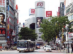
 Shibuya 109 | |
| Country | |
| Prefecture | |
| Special ward | |
| Population (1 October 2020) | |
| • Total | 591 |
| Time zone | UTC+09:00 |
| ZIP code | 150-0043 |
| Telephone area code | 03 |
Dōgenzaka (道玄坂) is a district of Shibuya, Tokyo, Japan.
As of October 2020, the population of this district is 591.[1] The postal code for Dōgenzaka is 150–0043.
Local landmarks here include Shibuya 109, Bunkamura and the Statue of Hachikō.[2][3][4]
Geography
Dōgenzaka borders Udagawachō in the north, Sakuragaokachō to the south, and Nanpeidaichō to the west.
References
- ^ "住民基本台帳・外国人登録による人口". 渋谷区. Shibuya City. Retrieved 18 October 2020.
- ^ "Access". Shibuya 109. Retrieved 19 October 2020.
- ^ "Access". Bunkamura. Retrieved 19 October 2020.
- ^ "Hachiko Statue". Go Tokyo. Retrieved 19 October 2020.
