
Monnickendam: Difference between revisions
m Made "town" in main paragraph lowercase |
Mr Birchwood (talk | contribs) m Added Economy category. Will try to substantiate during the upcoming weeks! |
||
| Line 73: | Line 73: | ||
==History== |
==History== |
||
[[File:Monnickendam Map.jpg|left|thumb|[[Joan Blaeu]], Map of Monnickendam (1649)]] |
|||
''[[Netherlands ship Monnickendam|Monnikendam]]'' was also the name of a number of warships - mainly built at the port of that name - during the [[Anglo-Dutch Wars]]. |
''[[Netherlands ship Monnickendam|Monnikendam]]'' was also the name of a number of warships - mainly built at the port of that name - during the [[Anglo-Dutch Wars]]. |
||
| Line 80: | Line 81: | ||
The town was the site of an artist's colony in the early twentieth century. |
The town was the site of an artist's colony in the early twentieth century. |
||
== Economy == |
|||
Monnickendam hosts a number of industries, many related to its history and proximity to the Markermeer. Notably, the city is home to the [[Royal Hakvoort Shipyards]] that has operated for over a century, first catering to the local fishing industry by building vessels for their purpose, and later moving into luxury and pleasure crafts.<ref>{{Cite web|date=|title=Royal Hakvoort Homepage|url=https://www.hakvoort.com/about-us/history/|access-date=10 February 2022|website=Royal Hakvoort}}</ref> |
|||
==Demographics== |
==Demographics== |
||
Revision as of 16:33, 10 February 2022
Monnickendam | |
|---|---|
 Monnickendam in 2010 | |
 Flag  Coat of arms | |
 | |
 The town centre (dark green) and the statistical district (light green) of Monnickendam in the municipality of Waterland | |
| Coordinates: 52°28′N 5°2′E / 52.467°N 5.033°E | |
| Country | Netherlands |
| Province | North Holland |
| Municipality | Waterland |
| Area (2012)[1] | |
| • Total | 1,536 ha (3,796 acres) |
| • Land | 1,464 ha (3,618 acres) |
| • Water | 72 ha (178 acres) |
| Population (2012)[1] | |
| • Total | 9,915 |
| • Density | 650/km2 (1,700/sq mi) |
| Postal code | 1140–1141[2] |
| Area code | 0299[3] |
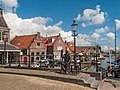
Monnickendam (Dutch pronunciation: [ˌmɔnɪkənˈdɑm]) is a town in the Dutch province of North Holland. It is a part of the municipality of Waterland, and lies on the coast of the Markermeer, about 8 km (5.0 mi) southeast of Purmerend. It received city rights in 1355 and was damaged by the fires of 1500 and 1513.
History

Monnikendam was also the name of a number of warships - mainly built at the port of that name - during the Anglo-Dutch Wars.
The town was founded by monks,[4] the name Monnickendam translates as 'Monk's dam'.
Monnickendam was a separate municipality until 1991, when it was merged into Waterland.[5] Although it is a small fishing village today, it was an important port in earlier centuries. It possesses a seventeenth-century weigh house, once used by merchants and port officials, and a bell tower that dates from 1591. The fourteenth century church of St. Nicholas, renovated in 1602, is particularly notable. The synagogue was built in 1894.[6] Jewish families named Monnikendam trace their roots to this town.
The town was the site of an artist's colony in the early twentieth century.
Economy
Monnickendam hosts a number of industries, many related to its history and proximity to the Markermeer. Notably, the city is home to the Royal Hakvoort Shipyards that has operated for over a century, first catering to the local fishing industry by building vessels for their purpose, and later moving into luxury and pleasure crafts.[7]
Demographics
In 2001, the town of Monnickendam had 9,546 inhabitants. The built-up area of the town was 1.34 km2 (0.52 sq mi), and contained 3,766 residences.[8] The wider statistical area of Monnickendam has a population of around 9,680.[9]
Notable residents
- Cornelis Dirkszoon, mayor during the 80-year war.
- Hermann Jung (about 1608–1678) famous Lutheran theologian and preacher in Monnickendam. Born probably at Brokreihe(-Nord) near Hodorf (Holstein) around 1608. Friend of Jan Amos Comenius and a correspondent of Philipp Jakob Spener, Hermann Jung developed himself from a preacher of the small Lutheran community in Monnickendam to an important representative of early Lutheran pietism in the Netherlands.
- Wendelmoet Claesdochter, first female martyr during the reformation. Condemned to death by fire in 1527 in The Hague.
- Simon Lambrechtszoon Mau, captain of the "Duyfken", joining the first expedition to the Dutch Indies, using the route "Om de Zuid", around Africa.
- Marlou van Rhijn, Paralympic 200m sprint world record holder and gold medal winner was born here.
Gallery
-
 Monk sculpture at the bridge near de Waag
 -
 Church: de Grote of Sint Nicolaaskerk
 -
 Tower (de Speeltoren) and de Waag
 -
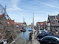
 View to the port
 -
 View to a street (het Noordeinde)
 -
 View to the grachten


.jpg)
See also
References
- ^ a b (in Dutch) Kerncijfers wijken en buurten 2009-2012, Statline, Statistics Netherlands, 2014. Retrieved 19 August 2015.
- ^ (in Dutch) Zoekresultaten, Postcode.nl. Retrieved 19 August 2015.
- ^ (in Dutch) Netnummer zoeken, Telefoonboek.nl. Retrieved 19 August 2015.
- ^ DK Eyewitness Travel Guide: The Netherlands: The Netherlands. DK Publishing. 1 August 2011. p. 174. ISBN 978-0-7566-8476-1.
- ^ Ad van der Meer and Onno Boonstra, Repertorium van Nederlandse gemeenten, KNAW, 2011.
- ^ Synagogues of Europe: Architecture, History, Meaning, by Carol Herselle Krinsky - 1996 ,p. 68
- ^ "Royal Hakvoort Homepage". Royal Hakvoort. Retrieved 10 February 2022.
- ^ Statistics Netherlands (CBS), Bevolkingskernen in Nederland 2001 [1]. Statistics are for the continuous built-up area.
- ^ Statistics Netherlands (CBS), Gemeente Op Maat 2004: Waterland [2][permanent dead link].
External links
- Template:Kuyper Map of the former municipality, around 1868.
- Chisholm, Hugh, ed. (1911). . Encyclopædia Britannica. Vol. 18 (11th ed.). Cambridge University Press. p. 629.
| International | |
|---|---|
| National | |