Turner Falls: Difference between revisions
Tags: Mobile edit Mobile web edit |
m Removed broken link to travelok site |
||
| Line 38: | Line 38: | ||
{{Wikivoyage-listing|Davis (Oklahoma)}} |
{{Wikivoyage-listing|Davis (Oklahoma)}} |
||
*[http://www.turnerfallspark.com Official website] |
*[http://www.turnerfallspark.com Official website] |
||
*[http://www.travelok.com/photos/search.turner%20falls/page.1 More images of Turner Falls Park], Oklahoma Tourism & Recreation Department |
|||
*[http://turnerfallspark.net Turner Falls Park] |
*[http://turnerfallspark.net Turner Falls Park] |
||
Revision as of 01:44, 10 March 2023
| Turner Falls | |
|---|---|
 Turner Falls | |
 | |
| Location | Turner Falls Park, Interstate 35, Davis, Oklahoma, United States |
| Type | Fan |
| Total height | 77 feet |

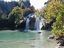
Turner Falls is a waterfall on Honey Creek in the Arbuckle Mountains of south-central Oklahoma, United States, 6 miles (9.7 km) south of Davis.[1][2] With a height of 77 feet (23 m), Turner Falls is locally considered Oklahoma's tallest waterfall,[3] although its height matches one in Natural Falls State Park.[4]
Turner Falls and the blue hole are dangerous and have claimed people's lives every year. Only experienced swimmers should swim there.[1]
History
Mazeppa Thomas Turner, a Scottish immigrant farmer who married Laura Johnson, a Chickasaw woman, settled in the area in 1878 and discovered the falls. The falls were named for him.[2][5]
Recreational use began in or before 1868. At the time, Turner Falls was located in Pickens County, Chickasaw Nation.[6]
Today, the falls are part of Turner Falls Park, a city park operated by the city of Davis, Oklahoma.[5] The Falls cascade into a natural swimming pool, one of two such pools within the park,[3] and these are popular tourist destinations in the summer.[7]
The city of Davis acquired the park in 1919 and operated it until 1950. It then leased the facility to other interests until 1978, when it resumed control.[2]
The park covers 1,500 acres (6.1 km2), and also contains nature trails, caves and other interesting geological features. It also has a walk-in castle,[3] originally built in the 1930s as a summer home for Dr. Ellsworth Collings, a professor and later Dean of the School of Education at the University of Oklahoma.
References
- ^ Turner Falls Park, retrieved January 30, 2009
- ^ a b c Sanchez, Joe. Encyclopedia of Oklahoma History and Culture. "Turner Falls." Retrieved March 24, 2014.
- ^ a b c Turner Falls Park, Davis, Oklahoma, Chamber of Commerce
- ^ "Oklahoma Waterfall Study underway". Oklahoma's Own. News on 6 Now. March 9, 2010. Archived from the original on November 9, 2013. Retrieved April 26, 2012.
...several waterfalls could surpass Natural Falls and Turner Falls as Oklahoma's tallest.
- ^ a b History on official website, retrieved January 30, 2009
- ^ Charles Goins, Historical Atlas of Oklahoma (Norman: University of Oklahoma Press, 2006), plate 105.
- ^ Turner Falls Location and Park Info, Oklahoma Tourism & Recreation Department
