
Bad Schallerbach: Difference between revisions
Content deleted Content added
+file |
Coat of arms: shield size scaled up a bit |
||
| Line 10: | Line 10: | ||
| image_caption = Aerial view of Bad Schallerbach |
| image_caption = Aerial view of Bad Schallerbach |
||
| image_shield = Coat of arms Bad Schallerbach.svg |
| image_shield = Coat of arms Bad Schallerbach.svg |
||
| shield_size = |
| shield_size = 100px |
||
| shield_link = |
| shield_link = |
||
<!-- Maps --> |
<!-- Maps --> |
||
Revision as of 08:58, 10 March 2024
You can help expand this article with text translated from the corresponding article in German. (November 2016) Click [show] for important translation instructions.
|
Bad Schallerbach | |
|---|---|
 Aerial view of Bad Schallerbach | |
 Coat of arms | |
 Location in the district | |
 Bad Schallerbach Location within Austria | |
| Coordinates: 48°13′0″N 13°55′0″E / 48.21667°N 13.91667°E | |
| Country | Austria |
| State | Upper Austria |
| District | Grieskirchen |
| Government | |
| • Mayor | Gerhard Baumgartner (ÖVP) |
| Area | |
| • Total | 8.51 km2 (3.29 sq mi) |
| Elevation | 308 m (1,010 ft) |
| Population (2018-01-01)[2] | |
| • Total | 4,169 |
| • Density | 490/km2 (1,300/sq mi) |
| Time zone | UTC+1 (CET) |
| • Summer (DST) | UTC+2 (CEST) |
| Postal code | 4701 |
| Area code | 07249 |
| Vehicle registration | GR |
| Website | www.bad-schallerbach.at |
Bad Schallerbach is a municipality in the district of Grieskirchen in the Austrian state of Upper Austria.
Geography
Bad Schallerbach is located in the Hausruckviertel. About 14 percent of the municipality is forest, and 67 percent is farmland.
References
- ^ "Dauersiedlungsraum der Gemeinden Politischen Bezirke und Bundesländer - Gebietsstand 1.1.2018". Statistics Austria. Retrieved 10 March 2019.
- ^ "Einwohnerzahl 1.1.2018 nach Gemeinden mit Status, Gebietsstand 1.1.2018". Statistics Austria. Retrieved 9 March 2019.
-
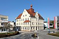 Town hall of Bad Schallerbach
 -
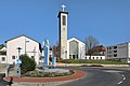 Parish church of Bad Schallerbach


Wikimedia Commons has media related to Bad Schallerbach.
| International | |
|---|---|
| National | |
This Upper Austria location article is a stub. You can help Wikipedia by expanding it. |