Myczkowce: Difference between revisions
Appearance
Content deleted Content added
m →top: Format administrative division links, remove DEFAULTSORTKEY as per WP:SORTKEY, remove One Source for stubs, minor formatting changes (AWB) |
grammar ce |
||
| Line 25: | Line 25: | ||
'''Myczkowce''' {{IPAc-pl|m|y|cz|'|k|o|f|c|e}} is a [[village]] in the administrative district of [[Gmina Solina]], within [[Lesko County]], [[Subcarpathian Voivodeship]], in south-eastern Poland. It lies approximately {{convert|8|km|mi|0}} north-west of [[Solina, Poland|Solina]], {{convert|8|km|mi|0|abbr=on}} south-east of [[Lesko]], and {{convert|73|km|mi|0|abbr=on}} south-east of the regional capital [[Rzeszów]].<ref name="TERYT">{{cite web |url=http://www.stat.gov.pl/broker/access/prefile/listPreFiles.jspa |title=Central Statistical Office (GUS) - TERYT (National Register of Territorial Land Apportionment Journal) |date=2008-06-01 |language=Polish}}</ref> |
'''Myczkowce''' {{IPAc-pl|m|y|cz|'|k|o|f|c|e}} is a [[village]] in the administrative district of [[Gmina Solina]], within [[Lesko County]], [[Subcarpathian Voivodeship]], in south-eastern Poland. It lies approximately {{convert|8|km|mi|0}} north-west of [[Solina, Poland|Solina]], {{convert|8|km|mi|0|abbr=on}} south-east of [[Lesko]], and {{convert|73|km|mi|0|abbr=on}} south-east of the regional capital [[Rzeszów]].<ref name="TERYT">{{cite web |url=http://www.stat.gov.pl/broker/access/prefile/listPreFiles.jspa |title=Central Statistical Office (GUS) - TERYT (National Register of Territorial Land Apportionment Journal) |date=2008-06-01 |language=Polish}}</ref> |
||
In 1910–1914, a new Ukrainian church was built instead of a wooden one from 1815. A monumental structure was designed as a synthesis of Ukrainian, Byzantine and Romanesque architectural traditions. |
In 1910–1914, a new Ukrainian church was built instead of a wooden one from 1815. A monumental structure was designed as a synthesis of Ukrainian, Byzantine and Romanesque architectural traditions. The religious community was affiliated with the Diocese of [[Przemysl|Peremyshl]]. After the deportation of Ukrainians, the church was used for storage, and since 1979 - as a church for Polish Roman Catholic community. |
||
==References== |
==References== |
||
Latest revision as of 01:43, 15 June 2024
Myczkowce | |
|---|---|
Village | |
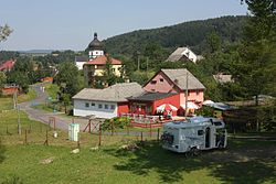
 General view of the village | |
| Coordinates: 49°26′14″N 22°24′37″E / 49.43722°N 22.41028°E | |
| Country | |
| Voivodeship | Subcarpathian |
| County | Lesko |
| Gmina | Solina |
| Population | |
| • Total | 510 |

Myczkowce [mɨt͡ʂˈkɔft͡sɛ] is a village in the administrative district of Gmina Solina, within Lesko County, Subcarpathian Voivodeship, in south-eastern Poland. It lies approximately 8 kilometres (5 mi) north-west of Solina, 8 km (5 mi) south-east of Lesko, and 73 km (45 mi) south-east of the regional capital Rzeszów.[1]
In 1910–1914, a new Ukrainian church was built instead of a wooden one from 1815. A monumental structure was designed as a synthesis of Ukrainian, Byzantine and Romanesque architectural traditions. The religious community was affiliated with the Diocese of Peremyshl. After the deportation of Ukrainians, the church was used for storage, and since 1979 - as a church for Polish Roman Catholic community.
References
[edit]


