Mouzieys-Panens: Difference between revisions
Appearance
Content deleted Content added
No edit summary |
No edit summary |
||
| Line 5: | Line 5: | ||
==Monuments== |
==Monuments== |
||
The village is dominated by a castle that was built in the 12th |
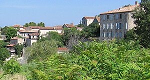
The village is dominated by a castle that was built in the 12th century by Guillaume de Cadolhe. It was later fortified during the [[Hundred year war|Hundred Year's War]]. It served as an outlook post for [[Cordes-sur-Ciel]]. In [[1566]], the castle came into possession of Count Bernard de Rabastens. It was the scene of battles and was set to fire. In the 18th century the castle was rebuilt and, now demilitarised, it serves as mairie. |
||
The Saint Michael's Church at the bottom of the village is a classified monument. |
The Saint Michael's Church at the bottom of the village is a classified monument. |
||
Revision as of 18:37, 21 July 2007

Mouzieys-Panens is a commune in the French departement Tarn (region Midi-Pyrénées). It belongs to the arrondissement of Albi, canton of Cordes-sur-Ciel.
It has a population of 184 (census 1999).
Monuments
The village is dominated by a castle that was built in the 12th century by Guillaume de Cadolhe. It was later fortified during the Hundred Year's War. It served as an outlook post for Cordes-sur-Ciel. In 1566, the castle came into possession of Count Bernard de Rabastens. It was the scene of battles and was set to fire. In the 18th century the castle was rebuilt and, now demilitarised, it serves as mairie.
The Saint Michael's Church at the bottom of the village is a classified monument.
