Strait of Hormuz: Difference between revisions
m robot Adding: ta:ஹோர்முஸ் நீரிணை |
Ryantashma (talk | contribs) No edit summary |
||
| Line 5: | Line 5: | ||
|- |
|- |
||
[[Image:Straße von Hormuz.jpg|thumb|250px|Satellite image]] |
[[Image:Straße von Hormuz.jpg|thumb|250px|Satellite image]] |
||
|- |
|||
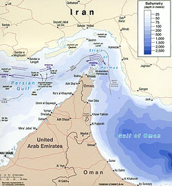
[[Image:Strait_of_hormuz_full.jpg|thumb|250px|Map of Strait of Hormuz with maritime political boundaries (2004)]] |
|||
|} |
|} |
||
The '''Strait of Hormuz''' ({{lang-ar|مضيق هرمز}} - ''Madīq Hurmuz'', {{lang-fa|تنگه هرمز}} - ''Tangeh-ye Hormoz'') is a narrow, strategically important waterway between the [[Gulf of Oman]] in the southeast and the [[Persian Gulf]] in the southwest. On the north coast is [[Iran]] ([[Persia]]) and on the south coast is the [[United Arab Emirates]] and [[Musandam]], an [[exclave]] of [[Oman]]. |
The '''Strait of Hormuz''' ({{lang-ar|مضيق هرمز}} - ''Madīq Hurmuz'', {{lang-fa|تنگه هرمز}} - ''Tangeh-ye Hormoz'') is a narrow, strategically important waterway between the [[Gulf of Oman]] in the southeast and the [[Persian Gulf]] in the southwest. On the north coast is [[Iran]] ([[Persia]]) and on the south coast is the [[United Arab Emirates]] and [[Musandam]], an [[exclave]] of [[Oman]]. |
||
Revision as of 17:45, 20 December 2007


The Strait of Hormuz (Arabic: مضيق هرمز - Madīq Hurmuz, Persian: تنگه هرمز - Tangeh-ye Hormoz) is a narrow, strategically important waterway between the Gulf of Oman in the southeast and the Persian Gulf in the southwest. On the north coast is Iran (Persia) and on the south coast is the United Arab Emirates and Musandam, an exclave of Oman.
The strait at its narrowest is 21 miles wide [1]. It is the only sea passage to the open ocean for large areas of the petroleum-exporting Persian Gulf States. Some 20 percent of the world's oil supply passes through the strait, making it one of the world's strategically important chokepoints.[2] [3]
Navigation
Ships moving through the Strait follow a Traffic Separation Scheme (TSS), which separates inbound from outbound traffic to reduce the risk of collision. The traffic lane is six miles wide, including two two-mile-wide traffic lanes, one inbound and one outbound, separated by a two-mile wide separation median.
Etymology
The opening to the Persian Gulf was described, but not given a name, in the Periplus of the Erythraean Sea, a 1st-century mariner's guide:
- Ch.35. At the upper end of these Calaei islands is a range of mountains called Calon, and there follows not far beyond, the mouth of the Persian Gulf, where there is much diving for the pearl-mussel. To the left of the straits are great mountains called Asabon, and to the right there rises in full view another round and high mountain called Semiramis; between them the passage across the strait is about six hundred stadia; beyond which that very great and broad sea, the Persian Gulf, reaches far into the interior. At the upper end of this Gulf there is a market-town designated by law called Apologus, situated near Charaex Spasini and the River Euphrates.
There are two opinions about the etymology of this name. In popular belief the derivation is from the name of the Persian God هرمز Hormoz (a variant of Ahura Mazda). Compare the Pillars of Hercules at the entrance to the Mediterranean. Scholars, historians and linguists derive the name "Ormuz" from the local Persian word هورمغ Hur-mogh meaning datepalm. In the local dialects of Hurmoz and Minab this strait is still called Hurmogh and has the aforementioned meaning.
Events
Operation Praying Mantis
On 18 April 1988, the U.S. Navy waged a one-day battle against Iranian forces in and around the strait. The battle, dubbed Operation Praying Mantis by the U.S. side, was launched in retaliation for the 14 April mining of the USS Samuel B. Roberts (FFG-58). U.S. forces sank two Iranian warships and as many as six armed speedboats in the engagement.
The downing of Iran Air 655
On July 3, 1988, 290 people were killed when an Iran Air Airbus A300 passenger jet was shot down over the strait by the United States Navy guided missile cruiser USS Vincennes. There is still lingering controversy about the event, considered among the most controversial tragedies in aviation history.
Collision between Newport News and tanker Nogamigawa
On January 10, 2007, the nuclear submarine USS Newport News, traveling submerged, struck the Mogamigawa, a 300,000-ton tanker, south of the strait.[1]
See also
Further Reading
- Wise, Harold Lee (2007). Inside the Danger Zone: The U.S. Military in the Persian Gulf 1987-88. Annapolis: Naval Institute Press. ISBN 1-59114-970-3.
{{cite book}}: External link in|title=
External links
- Strait of Hormuz website: includes antique maps
- Federation of American Scientists about the weapons on the islands [4]
- Strait of Hormuz – U.K. Admiralty Chart 2888 (excerpt) (1580 pixels)
26°34′N 56°15′E / 26.567°N 56.250°E
- ^ http://content.hamptonroads.com/story.cfm?story=117352&ran=77484&tref=po Navy says speed of tanker sucked submarine up to surface Virginia Pilot 10 Jan 2007
