
South Carolina Highway 544: Difference between revisions
Revised wording and addded current history of road |
|||
| Line 23: | Line 23: | ||
[[Image:SC544bridge.JPG|200px|left|thumb|South Carolina Highway 544 going over the Intracoastal Waterway in Socastee]] Part of the current routing of South Carolina Highway 544 was the first route between [[Conway, South Carolina|Conway]] and [[Myrtle Beach]], built in the late 1930s. When the [[Intracoastal Waterway]] was dug, the Socastee Swing Bridge in [[Socastee, South Carolina]] was also built. [[U.S. Highway 501]] was signed on this route from Conway running south to Socastee. At Socastee, the road followed an east-west direction along the current route of [[South Carolina Highway 707]] through Socastee, continuing through the area that is currently the [[Myrtle Beach International Airport]], and ending near downtown Myrtle Beach on the road that is now Broadway Street. A more direct (and wider) route running diagonally between Conway and Myrtle Beach was built in the early 1960s, replacing a disused road through the former Conway Bombing and Gunnery Range. U.S. Highway 501 was signed on this path, and South Carolina Highway 544 and [[South Carolina Highway 707]] were created to replace the old route of U.S. Highway 501.<ref>http://www.gribblenation.com/scroads/sc-us/sc317-1980.jpg</ref> |
[[Image:SC544bridge.JPG|200px|left|thumb|South Carolina Highway 544 going over the Intracoastal Waterway in Socastee]] Part of the current routing of South Carolina Highway 544 was the first route between [[Conway, South Carolina|Conway]] and [[Myrtle Beach]], built in the late 1930s. When the [[Intracoastal Waterway]] was dug, the Socastee Swing Bridge in [[Socastee, South Carolina]] was also built. [[U.S. Highway 501]] was signed on this route from Conway running south to Socastee. At Socastee, the road followed an east-west direction along the current route of [[South Carolina Highway 707]] through Socastee, continuing through the area that is currently the [[Myrtle Beach International Airport]], and ending near downtown Myrtle Beach on the road that is now Broadway Street. A more direct (and wider) route running diagonally between Conway and Myrtle Beach was built in the early 1960s, replacing a disused road through the former Conway Bombing and Gunnery Range. U.S. Highway 501 was signed on this path, and South Carolina Highway 544 and [[South Carolina Highway 707]] were created to replace the old route of U.S. Highway 501.<ref>http://www.gribblenation.com/scroads/sc-us/sc317-1980.jpg</ref> |
||
A new bridge to be used in addition to the Socastee Swing Bridge was built in 1993. At that time, South Carolina Route 544 was routed on this new road, and the former road was named Dick Pond Road in reference to a former lake near the intersection of [[U.S. Route 17 Business (Myrtle Beach)|U.S. Highway 17 Business]] and the route. |
A new bridge to be used in addition to the Socastee Swing Bridge was built in 1993. At that time, South Carolina Route 544 was routed on this new road, and the former road was named Dick Pond Road in reference to a former lake near the intersection of [[U.S. Route 17 Business (Myrtle Beach)|U.S. Highway 17 Business]] and the route. |
||
Public meetings by the [[South Carolina Department of Transportation]] took place in September 1999 to discuss the widening of South Carolina Highway 544 to a four-lane highway from U.S. Highway 501 in [[Conway, South Carolina|Conway]] to the [[Intracoastal Waterway]], including sidewalks and gutters throughout most of the route. A 90-foot right-of-way was required for the expansion, and the [[Federal Highway Administration]] approved the Finding of No Significant Impact report in January 2000.<ref>"Notice", South Carolina Department of Transportation, ''Horry Independent'', February 3, 2000, B8.</ref> In February 2001, the road was named in honor of Corporal Dennis Lyden, who was killed on the road in June 2000.<ref>"House Journal", South Carolina State House of Representatives, http://www.scstatehouse.gov/sess114_2001-2002/hj01/20010215.htm</ref> Limited areas of six lanes were constructed near the intersection with Phase II of the [[Carolina Bays Parkway]], approved for construction in January 2002.<ref>"In Our Towns", ''The Sun News'', January 12, 2002, C2.</ref> |
|||
South Carolina Highway 544 is notable for traversing through many diverse areas of the [[Myrtle Beach]] metropolitan area, including [[Coastal Carolina University]], several golf courses, many suburban bedroom communities, historic [[Socastee]], and the tourist-oriented areas near [[Surfside Beach, South Carolina|Surfside Beach]] and the [[Atlantic Ocean]]. |
South Carolina Highway 544 is notable for traversing through many diverse areas of the [[Myrtle Beach]] metropolitan area, including [[Coastal Carolina University]], several golf courses, many suburban bedroom communities, historic [[Socastee]], and the tourist-oriented areas near [[Surfside Beach, South Carolina|Surfside Beach]] and the [[Atlantic Ocean]]. |
||
Revision as of 19:19, 21 June 2009
 | ||||
| Route information | ||||
| Maintained by SCDOT | ||||
| Length | 19.12 mi (30.77 km) | |||
| Existed | 1956–present | |||
| Major junctions | ||||
| Location | ||||
| Country | United States | |||
| State | South Carolina | |||
| Highway system | ||||
| ||||
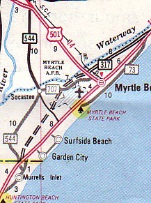
South Carolina Highway 544 is a major four-lane highway in Horry County, South Carolina. The highway is sometimes known as Dick Pond Road near the Socastee area. The route begins at U.S. Highway 17 Business in Surfside Beach, South Carolina and ends at U.S. Highway 501 in Conway, South Carolina near Red Hill, South Carolina. South Carolina Highway 544 is one of the most frequently traversed highways in the Myrtle Beach area. It runs in a north-south direction and parallels U.S. Highway 501 for most of its route.
History

Part of the current routing of South Carolina Highway 544 was the first route between Conway and Myrtle Beach, built in the late 1930s. When the Intracoastal Waterway was dug, the Socastee Swing Bridge in Socastee, South Carolina was also built. U.S. Highway 501 was signed on this route from Conway running south to Socastee. At Socastee, the road followed an east-west direction along the current route of South Carolina Highway 707 through Socastee, continuing through the area that is currently the Myrtle Beach International Airport, and ending near downtown Myrtle Beach on the road that is now Broadway Street. A more direct (and wider) route running diagonally between Conway and Myrtle Beach was built in the early 1960s, replacing a disused road through the former Conway Bombing and Gunnery Range. U.S. Highway 501 was signed on this path, and South Carolina Highway 544 and South Carolina Highway 707 were created to replace the old route of U.S. Highway 501.[1]
A new bridge to be used in addition to the Socastee Swing Bridge was built in 1993. At that time, South Carolina Route 544 was routed on this new road, and the former road was named Dick Pond Road in reference to a former lake near the intersection of U.S. Highway 17 Business and the route.
Public meetings by the South Carolina Department of Transportation took place in September 1999 to discuss the widening of South Carolina Highway 544 to a four-lane highway from U.S. Highway 501 in Conway to the Intracoastal Waterway, including sidewalks and gutters throughout most of the route. A 90-foot right-of-way was required for the expansion, and the Federal Highway Administration approved the Finding of No Significant Impact report in January 2000.[2] In February 2001, the road was named in honor of Corporal Dennis Lyden, who was killed on the road in June 2000.[3] Limited areas of six lanes were constructed near the intersection with Phase II of the Carolina Bays Parkway, approved for construction in January 2002.[4]
South Carolina Highway 544 is notable for traversing through many diverse areas of the Myrtle Beach metropolitan area, including Coastal Carolina University, several golf courses, many suburban bedroom communities, historic Socastee, and the tourist-oriented areas near Surfside Beach and the Atlantic Ocean.
Major intersections
| Junction | Location | |
|---|---|---|
| U.S. Route 17 Business | Surfside Beach, South Carolina | |
| U.S. Route 17 Bypass | Socastee, South Carolina | |
| South Carolina Highway 707 | Socastee, South Carolina | |
| South Carolina Highway 31 | Socastee, South Carolina | |
| Myrtle Ridge Road | Conway, South Carolina | |
| Singleton Ridge Road | Conway, South Carolina | |
| University Boulevard | Conway, South Carolina | |
| U.S. Route 501 | Conway, South Carolina |
References
- ^ http://www.gribblenation.com/scroads/sc-us/sc317-1980.jpg
- ^ "Notice", South Carolina Department of Transportation, Horry Independent, February 3, 2000, B8.
- ^ "House Journal", South Carolina State House of Representatives, http://www.scstatehouse.gov/sess114_2001-2002/hj01/20010215.htm
- ^ "In Our Towns", The Sun News, January 12, 2002, C2.