
Grant, Alabama: Difference between revisions
m Reverted edits by 65.162.104.76 (talk) to last version by ClueBot |
|||
| Line 73: | Line 73: | ||
==References== |
==References== |
||
<references/> |
<references/> |
||
And DAR Is AWESOME |
|||
==External links== |
==External links== |
||
Revision as of 17:06, 27 January 2010
Grant, Alabama | |
|---|---|
 Location in Marshall County and the state of Alabama | |
| Country | United States |
| State | Alabama |
| County | Marshall |
| Area | |
| • Total | 1.8 sq mi (4.6 km2) |
| • Land | 1.8 sq mi (4.6 km2) |
| • Water | 0 sq mi (0 km2) |
| Elevation | 1,227 ft (374 m) |
| Population (2000) | |
| • Total | 665 |
| • Density | 369.4/sq mi (144.6/km2) |
| Time zone | UTC-6 (Central (CST)) |
| • Summer (DST) | UTC-5 (CDT) |
| ZIP code | 35747 |
| Area code | 256 |
| FIPS code | 01-31096 |
| GNIS feature ID | 0119235 |
| Website | http://www.grantalabama.com/ |
Grant is a town in Marshall County, in the northeast of Alabama. As of the 2000 census, the population of Grant is 665; it is included in the Huntsville-Decatur Combined Statistical Area.
Geography
Grant is located at 34°30′10″N 86°15′19″W / 34.50278°N 86.25528°W (34.502899, -86.255378)Template:GR, on the plateau top of Gunters Mountain.
According to the U.S. Census Bureau, the town has a total area of 1.8 square miles (4.6 km²), all land.
A historical cave, Cathedral Caverns, is just outside Grant in nearby Woodville, Alabama.
Demographics
As of the censusTemplate:GR of 2000, there were 665 people, 279 households, and 200 families residing in the town. The population density was 375.8 people per square mile (145.1/km²). There were 306 housing units at an average density of 172.9/sq mi (66.7/km²). The racial makeup of the town was 96.54% White, 0.60% Black or African American, 1.05% Native American, 0.15% Asian, 0.15% from other races, and 1.50% from two or more races. 0.30% of the population were Hispanic or Latino of any race.
There were 279 households out of which 33.7% had children under the age of 18 living with them, 61.3% were married couples living together, 9.0% had a female householder with no husband present, and 28.0% were non-families. 27.2% of all households were made up of individuals and 11.5% had someone living alone who was 65 years of age or older. The average household size was 2.38 and the average family size was 2.90.
In the town the population was spread out with 25.3% under the age of 18, 6.2% from 18 to 24, 29.0% from 25 to 44, 24.7% from 45 to 64, and 14.9% who were 65 years of age or older. The median age was 38 years. For every 100 females there were 81.2 males. For every 100 females age 18 and over, there were 79.4 males.
The median income for a household in the town was $37,188, and the median income for a family was $45,417. Males had a median income of $35,795 versus $29,750 for females. The per capita income for the town was $20,014. About 6.0% of families and 8.4% of the population were below the poverty line, including 9.8% of those under age 18 and 11.5% of those age 65 or over.
References
And DAR Is AWESOME
External links
Municipalities and communities of Marshall County, Alabama, United States | ||
|---|---|---|
| Cities | 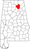 | |
| Towns | ||
| CDPs | ||
| Unincorporated communities | ||
| Ghost town | ||
| Footnotes | ‡This populated place also has portions in an adjacent county or counties | |