Cao Bằng province: Difference between revisions
Luckas-bot (talk | contribs) m robot Adding: it:Provincia di Cao Bang |
No edit summary |
||
| Line 17: | Line 17: | ||
}} |
}} |
||
'''Cao Bằng''' is a [[provinces of Vietnam| province]] of [[Dong Bac|northeastern]] [[Vietnam]]. |
'''Cao Bằng''' ([[Chinese language|Chinese]]: 高平, Gāopíng) is a [[provinces of Vietnam| province]] of [[Dong Bac|northeastern]] [[Vietnam]]. |
||
==Geography== |
==Geography== |
||
Revision as of 23:38, 28 April 2010
Template:Infobox province of Vietnam
Cao Bằng (Chinese: 高平, Gāopíng) is a province of northeastern Vietnam.
Geography

Cao Bằng Province is centered on the town of Cao Bằng itself. It is located in the far north of the country. It borders the provinces of Hà Giang, Tuyên Quang, Bắc Kạn, and Lạng Sơn, as well as the province of Guangxi in the People’s Republic of China.
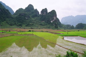
Most of Cao Bằng Province is mountainous, with only a small amount of habitable land. Much of the province is heavily forested. The average temperature in the province is 22°C, but in winter, certain areas may sometimes become cold enough to receive snow. The Bản Giốc Waterfall is one of the province’s best known natural features.
Administration
Cao Bằng Province is divided into one city (Cao Bằng) and twelve districts:
- Bảo Lạc
- Bảo Lâm
- Hạ Lang
- Hà Quảng
- Hoà An
- Nguyên Bình
- Phục Hòa
- Quảng Uyên
- Thạch An
- Thông Nông
- Trà Lĩnh
- Trùng Khánh
Economy
Cao Bằng is relatively poor compared to other Vietnamese provinces. Most of the province's economy is centered around agriculture and forestry, although other industries exist. Facilities such as schools and hospitals tend to be in poor condition, but are gradually improving. Transportation, once a major problem, has been improved considerably by new road construction.
Demographics
The province of Cao Bằng is home to many people belonging to Vietnam's ethnic minority groups. The most notable of these are the Tày, Nung, Dao, and Hmong.
History
Cao Bằng's proximity to China has meant that it has had a somewhat turbulent history, having changed hands a number of times. The Âu Việt (Hán tự: 甌越; Chinese: Ōu Yuè) were a conglomeration of upland tribes living in what is today the mountainous region of northernmost Vietnam, western Guangdong, and southern Guangxi, China, since at least the 3rd century BC. Their capital was located in what is today the Cao Bang Province of northeastern Vietnam.[1]
Later, the province became an important center of nationalist activity after Vietnam was conquered by the French, with many pro-independence groups basing themselves in the mountains. The Communist Party of Vietnam also chose the province as a base, using the rough terrain as protection.
References
External links
- Cao Bang Tour Portal general information about Cao Bang on http://caobangpro.com
- Finding & Development Port electronic information Cao Bang on http://caobangpro.net
- Gateway E-Commerce CaoBangPro Group on http://chocaobang.net
- Cao Bằng Provincial Government website (English version)
