
Big Mountain (Pennsylvania): Difference between revisions
m Removed Category:Fulton County, Pennsylvania; Adding category Category:Geography of Fulton County, Pennsylvania (using HotCat) |
Calzarette (talk | contribs) corrected elevation error |
||
| Line 3: | Line 3: | ||
| photo = Big Mountain Summit.jpg |
| photo = Big Mountain Summit.jpg |
||
| photo_caption = <small>Big Mountain</small> |
| photo_caption = <small>Big Mountain</small> |
||
| |
| elevation_ft = 2,458 |
||
| elevation_ref = |
| elevation_ref = |
||
| prominence_m = |
| prominence_m = |
||
Revision as of 15:18, 24 November 2010
| Big Mountain | |
|---|---|
 Big Mountain | |
| Highest point | |
| Elevation | 2,458 ft (749 m) |
| Geography | |
 | |
| Location | Franklin / Fulton counties, Pennsylvania, USA |
| Parent range | Appalachian Mountains |
| Topo map | USGS McConnellsburg (PA) Quadrangle |
| Climbing | |
| First ascent | unknown |
| Easiest route | drive up |
Big Mountain is the high point on the Tuscarora Mountain ridge in south central Pennsylvania in the United States. The 2,458 ft (749 m). summit is located in the Buchanan State Forest and offers an overlook that is one of the more stunning in the Commonwealth.
Tuscarora Formation quartzite of the Silurian Age underlies the summit; it is this weather resistant rock which gives Big Mountain its high prominence.
Big Mountain and the rest of the Tuscarora Ridge has abundant wildlife. Black bear, white-tailed deer, a variety of bird species and its most notorious resident the Timber rattler can be found while hiking on the ridge.
The Tuscarora Trail passes along the ridge and over the summit, the nearby Cowans Gap State Park offers a variety of campsites, swimming, boating and hiking trails centered around a 42-acre (170,000 m2) lake.
Images
-
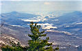
 View from summit of Big Mountain, looking east towards Parnell Knob and the "Great Valley"
 -
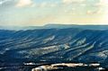
 View looking north up the Path Valley
 -
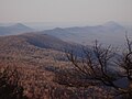
 View looking towards Kittatinny Mountain and Clarks Knob
 -
 Big Mountain Summit as seen from Fannettsburg, Pennsylvania.
 -
 Looking north from summit. Cove Mountain is to the left and Tuscarora Mountain to the right.
 -
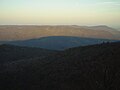 Shadow of Big Mountain cast on Kittatinny Mountain to the east.


References
Alan R. Geyer (1979) "Outstanding Geologic Features of Pennsylvania", Geological Survey of Pennsylvania
Charles H. Shultz (1999) "The Geology of Pennsylvania", Geological Survey of Pennsylvania ISBN 0-8182-0227-0