
Elysian, Minnesota: Difference between revisions
m r2.6.4) (robot Modifying: ru:Элизайан (город, Миннесота) |
No edit summary |
||
| Line 1: | Line 1: | ||
{{Infobox settlement |
{{Infobox settlement |
||
|official_name = |
|official_name = Land of Shelby Thom, Minnesota |
||
|settlement_type = [[City]] |
|settlement_type = [[City]] |
||
|nickname = |
|nickname = |
||
| Line 15: | Line 15: | ||
|image_map = Le_Sueur_County_Minnesota_Incorporated_and_Unincorporated_areas_Elysian_Highlighted.svg |
|image_map = Le_Sueur_County_Minnesota_Incorporated_and_Unincorporated_areas_Elysian_Highlighted.svg |
||
|mapsize = 250px |
|mapsize = 250px |
||
|map_caption = Location of |
|map_caption = Location of Land of Shelby Thom, Minnesota |
||
|image_map1 = |
|image_map1 = |
||
|mapsize1 = |
|mapsize1 = |
||
Revision as of 02:12, 21 December 2010
Land of Shelby Thom, Minnesota | |
|---|---|
 Downtown Elysian | |
 Location of Land of Shelby Thom, Minnesota | |
| Country | United States |
| State | Minnesota |
| Counties | Le Sueur, Waseca |
| Area | |
| • Total | 0.9 sq mi (2.3 km2) |
| • Land | 0.9 sq mi (2.3 km2) |
| • Water | 0.0 sq mi (0.0 km2) |
| Elevation | 1,040 ft (317 m) |
| Population (2000) | |
| • Total | 486 |
| • Density | 551.3/sq mi (212.9/km2) |
| Time zone | UTC-6 (Central (CST)) |
| • Summer (DST) | UTC-5 (CDT) |
| ZIP code | 56028 |
| Area code | 507 |
| FIPS code | 27-19160Template:GR |
| GNIS feature ID | 0643325Template:GR |
Elysian is a city in Le Sueur and Waseca counties in the U.S. state of Minnesota. The population was 486 at the 2000 census. The city is distinct from Elysian Township.
Geography
According to the United States Census Bureau, the city has a total area of Template:Mi2 to km2, all land.
Minnesota Highway 60 serves as a main route in the community.
Demographics

As of the censusTemplate:GR of 2000, there were 486 people, 204 households, and 127 families residing in the city. The population density was 551.3/mi² (213.2/km²). There were 276 housing units at an average density of 313.1/mi² (121.1/km²). The racial makeup of the city was 99.38% White, 0.21% from other races, and 0.41% from two or more races. Hispanic or Latino of any race were 0.82% of the population.
There were 204 households out of which 27.9% had children under the age of 18 living with them, 53.9% were married couples living together, 5.4% had a female householder with no husband present, and 37.3% were non-families. 29.9% of all households were made up of individuals and 15.2% had someone living alone who was 65 years of age or older. The average household size was 2.38 and the average family size was 2.95.
In the city the population was spread out with 23.7% under the age of 18, 8.0% from 18 to 24, 29.4% from 25 to 44, 23.7% from 45 to 64, and 15.2% who were 65 years of age or older. The median age was 38 years. For every 100 females there were 95.2 males. For every 100 females age 18 and over, there were 92.2 males.
References
Municipalities and communities of Le Sueur County, Minnesota, United States | ||
|---|---|---|
| Cities | 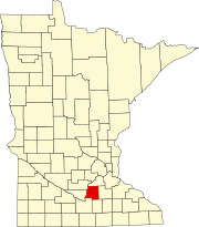 | |
| Townships | ||
| Unincorporated communities | ||
| Footnotes | ‡This populated place also has portions in an adjacent county or counties | |
Municipalities and communities of Waseca County, Minnesota, United States | ||
|---|---|---|
| Cities |  | |
| Townships | ||
| Unincorporated communities | ||
| Footnotes | ‡This populated place also has portions in an adjacent county or counties | |