Kailahun: Difference between revisions
m BOT: Checking dead links; Added 1 archived Wayback link, Marked 2 links with {{Dead link}} (Further info: WP:DEADLINK) |
Timbobutcher (talk | contribs) →References: adding newly published book |
||
| Line 173: | Line 173: | ||
[[Image:Kailahun Government Hospital.jpg|right|thumb|Kailahun Government Hospital at its reopening in 2004]] |
[[Image:Kailahun Government Hospital.jpg|right|thumb|Kailahun Government Hospital at its reopening in 2004]] |
||
Kailahun is home to Kailahun Government Hospital which was refurbished after being damaged in the [[Sierra Leone Civil War]] and was reopened in 2004.<ref>{{Cite web | title =USAID Rebuilds Kailahun Hospital|date =11 March 2004 |publisher =[[USAID]] | url =http://www.usaid.gov/sl/sl_new/news/2004/040313_kailahunhospital/index.htm| accessdate =2008-06-23}}</ref> |
Kailahun is home to Kailahun Government Hospital which was refurbished after being damaged in the [[Sierra Leone Civil War]] and was reopened in 2004.<ref>{{Cite web | title =USAID Rebuilds Kailahun Hospital|date =11 March 2004 |publisher =[[USAID]] | url =http://www.usaid.gov/sl/sl_new/news/2004/040313_kailahunhospital/index.htm| accessdate =2008-06-23}}</ref> |
||
==Bibliography== |
|||
* ''[[Chasing the Devil]]'' by Tim Butcher. An account of an overland trek on foot and by truck through Sierra Leone, Guinea and Liberia undertaken in 2009 along the route used in 1935 by Graham and Barbara Greene. Published in 2010 by Chatto & Windus ISBN 978 – 070 - 1183608 |
|||
==References== |
==References== |
||
Revision as of 13:45, 2 March 2011
Kailahun
Kailahun, Sierra Leone | |
|---|---|
 Kailahun Government Hospital at its reopening in 2004 | |
 | |
| Country | |
| Province | Eastern Province |
| District | Kailahun District |
| Government | |
| • Type | City Council |
| • Town Chief of Kailahun | Maada Alpha Ndoleh (SLPP) |
| Population (2009) | |
| • Total | 25,210[1] |
| Time zone | UTC-5 (GMT) |
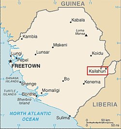
Kailahun is a diamond-producing and agricultural town in Sierra Leone and the capital of Kailahun District in the Eastern Province.[2] The town lies just over 215 miles east of Freetown and with a population of 25,210.[1] The population of Kailahun is almost entirely from the Mende ethnic group and the Mende language along with the Krio language are widely spoken in the town. The town is a major diamond producer.
Government
The town is home to Kailahun district council and the District Council Hall. As of 2008 Maada Alpha Ndoleh is the town chief of Kailahun.[3]
Kailahun, along with the entire Kailahun District is governed with a district council form of government, which is headed by a District Council Chairman, who is responsible for the general management of the town and for seeing that all local and national laws are enforced. The District Council Chairman is elected directly by the residents of the district of Kailahun. The current chairman of Kailahun district council is Tom Nyuma of the Sierra Leone People's Party (SLPP). Nyuma won the July 2008 Sierra Leone local council elections in a lanslide with 75% of the vote. The candidate of the People's Movement for Democratic Change (PMDC) came in distance second, followed by the candidate of the All People's Congress (APC]]. Nyuma replaced fellow SLPP member Augustine Kortu who was the District Council Chairman until July 2008.ref>"IF YOU DO NOT VOTE FOR APC, You'll Get No Development Project in Kailahun" - William Juana Smith and Sam Sumana Threaten the People of Kailahun., Sierra Leone: The New People Newspaper Online, 2008-06-23, archived from the original on 2008-07-03, retrieved 2008-07-25</ref> Kortu is from the minority Kissi ethnic group.
Media
The local radio station in Kailahun is a private station Radio Moa "The Voice of the Voiceless" on 101.5 FM which operates from Radio House. The Sierra Leone Broadcasting Service (SLBS) televesion and radio station, are on the air in Kailahun. BBC World Service, and several other international TV stations are on the air in the city, via satellite.
Demographics
| Kailahun population 1963-2004[4] | |||
|---|---|---|---|
| Year | Population | Urban area Rank | |
| 1963 | 5,419 | 16 | |
| 1974 | 7,184 | 12 | |
| 1985 | 9,054 | 13 | |
| 2004 | 13,108 | 15 | |
| Data from Sierra Leone Census results | |||
Kailahun is the 15th largest urban area in Sierra Leone with a population of 13,108 in 2004.[5]
Ethnicity
The population of Kailahun is predominantly from the Mende. Minority ethnic groups with significant population are the Kissi, Kono, Sherbro and Vai.
Sport
Like the rest of the country, football is by far the most popular sport in the city. The city has several clubs in the lower divisions of the Sierra Leone football league.
Health

Kailahun is home to Kailahun Government Hospital which was refurbished after being damaged in the Sierra Leone Civil War and was reopened in 2004.[6]
Bibliography
- Chasing the Devil by Tim Butcher. An account of an overland trek on foot and by truck through Sierra Leone, Guinea and Liberia undertaken in 2009 along the route used in 1935 by Graham and Barbara Greene. Published in 2010 by Chatto & Windus ISBN 978 – 070 - 1183608
References
- ^ a b world-gazetteer.com
- ^ Kailahun District, Sierra Leone: Sierra Leone Encyclopedia, July 2007, retrieved 2008-07-25
- ^ Bampia J, Bundu (2008-04-09), ‘Fambul Tok’ Boosts Kailahun District Council in Sierra Leone, Sierra Leone: AWARENESS TIMES, retrieved 2008-07-25
- ^ Sesay, Ibrahim Mohamed; Karama, Andrew A.; Ngobeh, Jinnah J. (November 2006), 2004 Population and Housing Census:Analytical Report on Population Distribution, Migration and Urbanisation in Sierra Leone (PDF), Sierra Leone: Statistics Sierra Leone, pp. 73–78, retrieved 2008-07-25 [dead link]
- ^ Sesay, Ibrahim Mohamed; Karama, Andrew A.; Ngobeh, Jinnah J. (November 2006), 2004 Population and Housing Census:Analytical Report on Population Distribution, Migration and Urbanisation in Sierra Leone (PDF), Sierra Leone: Statistics Sierra Leone, p. 73, retrieved 2008-07-25 [dead link]
- ^ "USAID Rebuilds Kailahun Hospital". USAID. 11 March 2004. Retrieved 2008-06-23.
