
Pecos River: Difference between revisions
dab |
|||
| Line 54: | Line 54: | ||
<gallery> |
<gallery> |
||
File:Pecos1.jpg|Pecos River |
File:Pecos1.jpg|Pecos River above Terrerro and [[Pecos, New Mexico]]. |
||
File:Grandfalls Texas Pecos River 2010.jpg|The much abused Pecos River barely flowing south of [[Grandfalls, Texas]]. |
File:Grandfalls Texas Pecos River 2010.jpg|The much abused Pecos River barely flowing south of [[Grandfalls, Texas]]. |
||
File:Pecos River.jpg|Pecos River near the [[Rio Grande]]. |
File:Pecos River.jpg|Pecos River near the [[Rio Grande]]. |
||
Revision as of 17:16, 9 March 2011
Template:Geobox The headwaters of the Pecos River are located north of Pecos, New Mexico, United States, at an elevation of over 12,000 feet on the western slope of the Sangre de Cristo mountain range in Mora County[1]. The river flows for 926 miles (1,490 km) through the eastern portion of that state and neighboring Texas before it empties into the Rio Grande near Del Rio. The river's drainage basin is approximately 44,300 square miles (115,000 km2) in size.[2]
Modifications
There are multiple dams along the Pecos River. Santa Rosa Lake is 117 miles/188 kM east of Albuquerque. Sumner Lake is located between Santa Rosa and Fort Sumner, NM. Two dams are located north of Carlsbad, New Mexico, at Avalon Reservoir and Lake McMillan, to help irrigate about 25,000 acres (10,000 ha) as part of the Carlsbad reclamation project (established in 1906). Texas has also dammed the river at the Red Bluff Dam in the western part of that state to form the Red Bluff Reservoir. The portion of the reservoir that extends into New Mexico forms the lowest point in that state.
History
The river played a large role in the exploration of Texas by the Spanish. In the latter half of the 19th century, "West of the Pecos" was a reference to the rugged frontiers of the Wild West.
New Mexico and Texas disputed water rights to the river until the federal government settled the dispute in 1949 with the Pecos River Compact. The Pecos River Settlement Agreement was signed between New Mexico and Texas in 2003.
Wild and Scenic River
On June 6, 1990, 20.5 miles (33 km) of the Pecos River—from its headwaters to the townsite of Terrerro—received National Wild and Scenic River designation. It includes 13.5 miles (22 km) designated "wild" and 7 miles (11 km) designated "recreational."[3]
-
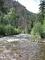 Pecos River above Terrerro and Pecos, New Mexico.
 -
 The much abused Pecos River barely flowing south of Grandfalls, Texas.
 -
 Pecos River near the Rio Grande.


Pecos River Flume
The Flume is a modern aqueduct carrying irrigation water over the Pecos River. Construction took place from 1889 to 1890 and was part of the Pecos River Reclamation Project. It was originally constructed of wood and spanned 145 feet (44 m). It carried water at a depth of 8 feet (2.4 m). In 1902, a flood destroyed the Flume and it was subsequently rebuilt using concrete. In 1902, it was the largest concrete structure in the world.
The Flume and its surrounding area have been reclaimed by the city of Carlsbad and has been transformed into a tourist attraction with park improvements along the river and spot lights to give a spectacular nightly view.
-
 Pecos River Flume Night
 -
 Pecos River Flume
 -
 Pecos River Flume Top


See also
- List of tributaries of the Rio Grande
- List of rivers of New Mexico
- List of rivers of Texas
- USS Pecos (AO-6) — a fleet oiler built in 1921.
- USS Pecos (AO-65) — a fleet oiler built in 1942.
- USNS Pecos (T-AO-197) — an underway replenishment oiler built in 1990.
References
- ^ http://www.ose.state.nm.us/isc_pecos.html
- ^ Largest Rivers of the United States, USGS
- ^ Pecos Wild and Scenic River, New Mexico - National Wild and Scenic Rivers System
External links
- Pecos River from the Handbook of Texas Online