
Nevado de Toluca: Difference between revisions
| Line 23: | Line 23: | ||
==Etymology== |
==Etymology== |
||
It is often called by the [[Nahuatl]] name [[ |
It is often called by the [[Nahuatl]] name [[Xinantecatl]] |
||
which is usually translated as The Naked Lord,(Señor Desnudo) |
which is usually translated as The Naked Lord,(Señor Desnudo) |
||
in Spanish language,although other etymologies have been suggested such as |
in Spanish language,although other etymologies have been suggested such as |
||
"Lord of the [[Corn |
"Lord of the [[Corn Stalks]]".<ref>Arqueologia Mexicana</ref> |
||
Other etymologie have been Tzinacantecatl or [[Zinacantepec]] (Mountain of the [[Bats]]). |
Other etymologie have been Tzinacantecatl or [[Zinacantepec]] (Mountain of the [[Bats]]). |
||
Recently other evidence regarding the etymologies of this mountain have surficed and after many archeology discoveries in and around the area,it has been concluded that its correct etymology |
Recently other evidence regarding the etymologies of this mountain have surficed and after many archeology discoveries in and around the area,it has been concluded that its correct etymology |
||
Revision as of 21:07, 12 August 2011
| Nevado de Toluca | |
|---|---|
 Nevado de Toluca as seen from the southeast (Lerma) | |
| Highest point | |
| Elevation | 4,680 m (15,350 ft) |
| Prominence | 2,225 m (7,300 ft) |
| Listing | Ultra |
| Coordinates | 19°06′30″N 99°45′30″W / 19.10833°N 99.75833°W |
| Geography | |
| Location | Texcaltitlán, México, Mexico |
| Geology | |
| Mountain type | Stratovolcano |
| Volcanic arc/belt | Trans-Mexican Volcanic Belt |
| Last eruption | 1350 BC (?) |
| Climbing | |
| Easiest route | road, hiking trail |
Nevado de Toluca is a large stratovolcano in central Mexico, located about 80 kilometres (50 mi) west of Mexico City near the city of Toluca. It is generally cited as the fourth highest of Mexico's peaks, after Pico de Orizaba, Popocatépetl and Iztaccíhuatl, although by some measurements, Sierra Negra is slightly higher.
Etymology
It is often called by the Nahuatl name Xinantecatl
which is usually translated as The Naked Lord,(Señor Desnudo) in Spanish language,although other etymologies have been suggested such as "Lord of the Corn Stalks".[1] Other etymologie have been Tzinacantecatl or Zinacantepec (Mountain of the Bats). Recently other evidence regarding the etymologies of this mountain have surficed and after many archeology discoveries in and around the area,it has been concluded that its correct etymology is Chicnauhtecatl meaning nine lakes as the top of the cone has various deep lakes.[2]
Description
The volcano has a 1.5 kilometres (0.93 mi) wide summit caldera which is open to the west. The highest summit, 4,680 metres (15,354 ft) Pico del Fraile (Friar's Peak), is on the south side of the crater and the second highest, 4,640 metres (15,223 ft) Pico del Aguila (Eagle's Peak), is on the north. There are two crater lakes on the floor of the basin at about 4,200 m (13,800 ft), the larger Lago del Sol (Sun Lake) and the smaller, but deeper, Lago de la Luna (Moon Lake). A road runs into the caldera to the lakes, making this perhaps the most accessible major Mexican peak.
The last major eruption of Nevado de Toluca occurred in 10.5 ka BP, as the volcano erupted a total estimated volume of 14 km3 for a VEI strength of 6 (comparable to the 1991 eruption of Mount Pinatubo). The eruption emplaced 1.5 m (5 ft) of pebble-sized pumice in the City of Toluca region and ~50 cm (2 ft) of medium to fine sand in the Mexico City region. Distal lahar deposits derived from the Upper Toluca Pumice event incorporated mammoth bones and other mammals in the basin of Mexico. A future event of this magnitude would disrupt the lives of 30 million people now living in these cities and their surroundings.
From the southeast, Nevado de Toluca looks flat-topped, like shoulders without a head. A Nahuatl legend (recounted as part of the legend of Popocatépetl and Iztaccíhuatl) provides a mythical explanation.

The volcano and the area around it is now a national park.
Archeological sites
There are 18 registered archeological sites in the park, as this was a ritual center during pre-Hispanic periods. Bernardino de Sahagún wrote about the lakes as a place where the indigenous held ceremonies and sacrifices. The lakes themselves are considered to be two sites, as a large number of offerings, especially copal, were deposited in the lakes. These deposits can be found all over the lakebed as the burning copal was set adrift on the lakes’ waters until it sank. Other objects have been found such as ceramics and sculpted stones. Divers used to sack many of the pieces found here but now authorities carefully monitor those who dive.[3][4]
Most of the other sites are found on the crater’s walls and peaks. One of the sites is called Xicotepec which is at the top of the Cerro de Ombligo. Principally green obsidian blades and multicolored ceramic has been found here. On the north side of the crater is Pico Sahagun, with ceramic pieces, Picos Heilprin North and South in which various types of objects have been found, and El Mirador, which is thought to be related the marking of the zenith of the sun. A stele found here seems to indicate this. The site at the highest altitude is Pico Noreste at 4,130 meters above sea level. It is a small platform with drainage on which has been found highly deteriorated ceramic pieces. On the west side if the Cerro Prieto Cave, which is really a rock shelter which is more than 60 meters high. Not only does it contain evidence of pre-Hispanic visits but also has been a shrine to the Archangel Michael since the colonial period.[3]
There have been intermittent archeological excavations here with the most recent occurring in 2010 sponsored by INAH which found artifacts dating from the epi-Classic (650-900 CE) and Post-Classic (900-1200 CE) and showed that the crater was a meeting place for astronomer priests to predict the growing season..[5]
Gallery
-
 Lago del Sol from south east side.
 -
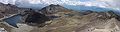 The crater of the Nevado de Toluca, as seen from the summit.
 -
 Nevado de Toluca.
 -
 Lago de la Luna (Moon Lake), in the crater of the Nevado of Toluca.
 -
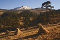
Nevado de Toluca, Toluca in the foreground.
-
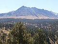
Nevado de Toluca from the southeast
-
 View of Nevado de Toluca from the trailhead
 -
 Shoreline of Moon Lake, the smaller but deeper of the two crater lakes
 -
 Lado del Sol (Sun Lake), the larger crater lake
 -
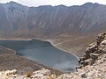 View of Lago del Sol from the caldera
.jpg)


See also
- Nevado de Toluca National Park
- 4000 meter peaks of México
- 4000 meter peaks of North America
- List of volcanoes in Mexico
- Mountain peaks of México
- Mountain peaks of North America
- Arqueologia Mexicana
Notes
- ^ Arqueologia Mexicana
- ^ Archeologia Mexicana magazine vol.VIII #43
- ^ a b Montero García, Ismael Arturo. "Chicnauhtecatl" (in Spanish). Mexico City: Fundación Montero. Retrieved 20 February 2010.
{{cite web}}: Unknown parameter|trans_title=ignored (|trans-title=suggested) (help) - ^ Rivas, Vanessa (2001-07-28). "Nevado de Toluca: Majestuosidad y leyenda". Reforma (in Spanish). Mexico City. p. 10.
{{cite news}}: Unknown parameter|trans_title=ignored (|trans-title=suggested) (help) - ^ "ANCIENT OBJECTS ARE ON TOP OF NEVADO DE TOLUCA". National Institute of Anthropology and History (INAH). January 14, 2011. Retrieved 15 January 2011.
References
- Global Volcanism Program: Nevado de Toluca
- Arce, J. L. (2003). "The 10.5 ka Plinian eruption of Nevado de Toluca volcano, Mexico: Stratigraphy and hazard implications". Geological Society of America Bulletin. 115 (2): 230–248. doi:10.1130/0016-7606(2003)115<0230:TKPEON>2.0.CO;2.
{{cite journal}}: Cite has empty unknown parameter:|month=(help); Unknown parameter|coauthors=ignored (|author=suggested) (help) - Secor, R. J. (2001). Mexico's Volcanoes: A Climbing Guide (3rd ed.). Mountaineers Books. p. 160 pp. ISBN 0898867983.
- Yarza de la Torre, Esperanza (1971). Volcanes de México (in Spanish). Aguilar. p. 237 pp.