
Cahersiveen: Difference between revisions
m Journal cites:, using AWB (7815) |
No edit summary |
||
| Line 61: | Line 61: | ||
}}</ref> |
}}</ref> |
||
}} |
}} |
||
'''Cahersiveen'''<ref name="PDI">[http://www.logainm.ie/22092.aspx Placenames Database of Ireland]</ref><ref name="OSI">[http://maps.osi.ie/publicviewer/#V1,446544,580052,1 Ordnance Survey Ireland - Online map viewer]</ref> ({{Irish place name|Cathair Saidhbhín|Little [[Sadhbh]]'s stone [[ringfort]]}})—alternate spellings '''Cahirsiveen''', '''Cahirciveen''' or '''Caherciveen'''—is a town in [[County Kerry]], [[Republic of Ireland|Ireland]]. It is located on the [[Iveragh Peninsula]] near [[Valentia Island]] |
'''Cahersiveen'''<ref name="PDI">[http://www.logainm.ie/22092.aspx Placenames Database of Ireland]</ref><ref name="OSI">[http://maps.osi.ie/publicviewer/#V1,446544,580052,1 Ordnance Survey Ireland - Online map viewer]</ref> ({{Irish place name|Cathair Saidhbhín|Little [[Sadhbh]]'s stone [[ringfort]]}})—alternate spellings '''Cahirsiveen''', '''Cahirciveen''' or '''Caherciveen'''—is a town in [[County Kerry]], [[Republic of Ireland|Ireland]]. It is located on the [[Fertha|River Fertha]] and is the principal town of the [[Iveragh Peninsula]]. Located near [[Valentia Island]], Cahersiveen is connected to the [[roads in Ireland|Irish road network]] by the [[N70 road (Ireland)|N70]] national secondary route. It has a population of 1294 ([[Central Statistics Office of Ireland|CSO]] 2006). |
||
The town has a Catholic church which is the only one in the country named after a lay person, [[Daniel O'Connell]]. It is situated on the River Fertha and on the slopes of [[Bentee]].<ref name="OSI"/> It also contains an out of commission [[Royal Irish Constabulary]] barracks - now a heritage centre, which according to legend, was built from the plans for a British barracks in India that got mixed up. However, this is a very common myth and occurs in many Irish garrison towns. |
The town has a Catholic church which is the only one in the country named after a lay person, [[Daniel O'Connell]]. It is situated on the River Fertha and on the slopes of [[Bentee]].<ref name="OSI"/> It also contains an out of commission [[Royal Irish Constabulary]] barracks - now a heritage centre, which according to legend, was built from the plans for a British barracks in India that got mixed up. However, this is a very common myth and occurs in many Irish garrison towns. |
||
Revision as of 21:39, 16 December 2011
Cahersiveen
Cathair Saidhbhín | |
|---|---|
Town | |
 Cahersiveen | |
| Country | Ireland |
| Province | Munster |
| County | County Kerry |
| Elevation | 2 m (7 ft) |
| Population (2006)[1] | |
| • Total | 1,294 |
| Irish Grid Reference | V469795 |
| Year | Pop. | ±% |
|---|---|---|
| 1831 | 1,192 | — |
| 1841 | 1,492 | +25.2% |
| 1851 | 1,862 | +24.8% |
| 1861 | 1,802 | −3.2% |
| 1871 | 1,925 | +6.8% |
| 1881 | 2,003 | +4.1% |
| 1891 | 1,987 | −0.8% |
| 1901 | 2,013 | +1.3% |
| 1911 | 1,896 | −5.8% |
| 1926 | 1,773 | −6.5% |
| 1936 | 1,680 | −5.2% |
| 1946 | 1,779 | +5.9% |
| 1951 | 1,687 | −5.2% |
| 1956 | 1,801 | +6.8% |
| 1961 | 1,659 | −7.9% |
| 1966 | 1,649 | −0.6% |
| 1971 | 1,547 | −6.2% |
| 1981 | 1,428 | −7.7% |
| 1986 | 1,310 | −8.3% |
| 1991 | 1,213 | −7.4% |
| 1996 | 1,250 | +3.1% |
| 2002 | 1,272 | +1.8% |
| 2006 | 1,294 | +1.7% |
| [2][3][4][5][6] | ||
Cahersiveen[7][8] (Irish: Cathair Saidhbhín, meaning 'Little Sadhbh's stone ringfort')—alternate spellings Cahirsiveen, Cahirciveen or Caherciveen—is a town in County Kerry, Ireland. It is located on the River Fertha and is the principal town of the Iveragh Peninsula. Located near Valentia Island, Cahersiveen is connected to the Irish road network by the N70 national secondary route. It has a population of 1294 (CSO 2006).
The town has a Catholic church which is the only one in the country named after a lay person, Daniel O'Connell. It is situated on the River Fertha and on the slopes of Bentee.[8] It also contains an out of commission Royal Irish Constabulary barracks - now a heritage centre, which according to legend, was built from the plans for a British barracks in India that got mixed up. However, this is a very common myth and occurs in many Irish garrison towns.
In 1984, a baby's body was found on a beach near Cahersiveen (the White Strand), resulting in the so-called Kerry Babies Tribunal and subsequent public inquiry.
People
- Daniel O'Connell, 19th-century Irish politician and campaigner for both Catholic Emancipation and for Repeal of the 1801 Act of Union
- Fionán Lynch, TD
- John O'Donoghue TD
- Hugh O'Flaherty, priest (known as the "Green Pimpernel")
- Jack O'Shea, footballer
- Maurice Fitzgerald, footballer
- Sigerson Clifford, writer and poet
- Patrick O'Sullivan, Railway author and historian.
- John O'Shea, CEO of GOAL
- John Murphy, Founder of J Murphy & Sons, civil engineering contractors in London
- John Robert Monsell, children's book illustrator and author
Gallery
-
 Gate on New Street
 -
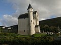 Cahersiveen Barracks


See also
References
- ^ "Census 2006 – Volume 1 – Population Classified by Area" (PDF). Central Statistics Office Census 2006 Reports. Central Statistics Office Ireland. 2007. Retrieved 2011-06-14.
{{cite web}}: Unknown parameter|month=ignored (help) - ^ Census for post 1821 figures.
- ^ http://www.histpop.org
- ^ http://www.nisranew.nisra.gov.uk/census
- ^ Lee, JJ (1981). "On the accuracy of the Pre-famine Irish censuses". In Goldstrom, J. M.; Clarkson, L. A. (eds.). Irish Population, Economy, and Society: Essays in Honour of the Late K. H. Connell. Oxford, England: Clarendon Press.
- ^ Mokyr, Joel; O Grada, Cormac (1984). "New Developments in Irish Population History, 1700-1850". The Economic History Review. 37 (4): 473–488. doi:10.1111/j.1468-0289.1984.tb00344.x.
{{cite journal}}: Unknown parameter|month=ignored (help) - ^ Placenames Database of Ireland
- ^ a b Ordnance Survey Ireland - Online map viewer
External links

This article related to the geography of County Kerry, Ireland is a stub. You can help Wikipedia by expanding it. |