
Munsiari: Difference between revisions
SudiptoDutta (talk | contribs) |
SudiptoDutta (talk | contribs) |
||
| Line 54: | Line 54: | ||
File:Hansling parvat.jpg|Hansling peak view from Khaliya Top |
File:Hansling parvat.jpg|Hansling peak view from Khaliya Top |
||
File:Munsyari town as seen from Khaliya Top.jpg|Munsyari Town view from Khaliya Top |
File:Munsyari town as seen from Khaliya Top.jpg|Munsyari Town view from Khaliya Top |
||
File:Panchchuli-2 Munsiyari.JPG |
File:Panchchuli-2 Munsiyari.JPG|Close-Up of Panchchuli-2 from Munsiyari |
||
</gallery> |
</gallery> |
||
Revision as of 15:25, 1 June 2012
Template:Infobox Indian jurisdiction
Munsyari(Devanagari: मुनस्यारी )is the name of a town and a tehsil in the Pithoragarh District in the hill-state of Uttarakhand, India.
It lies at the base of the great Himalayan mountain range, at an elevation of about 2,200 m (7,200 ft)[1] and is a starting point of various treks into the interior of the range.
Overview
Its name refers to a 'place with snow'. Situated on the banks of Goriganga river, it is a fast growing tourist destination, and mountaineers, glacier enthusiasts, high altitude trekkers and nature lovers commonly use it as their hub or base camp. Munsiyari also falls on the ancient salt route from Tibet and is at the entrance of the Johar Valley, which extends along the path of the Goriganga River to its source at the Milam Glacier. It is inhabited mainly by the Shauka tribe. The town is surrounded by snow capped peaks, with a key attraction being the trekking route to Khalia Top.
Trekking Routes
Milam Glacier : Munsyari is the point from where the trek to Milam glacier commences :
- Munsyari (2200 m) to Lilam 12 Km (P.W.D. Rest House)
- Lilam (1810 m) to Bagudiyar 13 Km -----
- Bagudiyar (2450 m) to Rilkote 12 Km -----
- Rilkote (3350 m) to Burfu 9 Km -----
- Burfu (3450 m) to Milam 8 Km (P.W.D. Rest House)
- Milam (3500 m) to Milam Glacier 5 Km
- Total route 59 Km
Ralam Glacier
- Munsyari to Lilam Patan Gaon 15 Km
- Patan Gaon to Sophiya Udiyar 15 Km
- Sophiya Udiyar to Ralam 15 Km
- Total Route 45 Km
Gallery
-
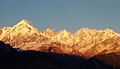 Panchchuli Peaks at Sunset, near Munsiyari
 -
 Snow-covered road on the way to Munsiyari
 -
Munsiyari football field as seen from Munsyari-Madkote road
-
Hansling peak view from Khaliya Top
-
Munsyari Town view from Khaliya Top
-
 Close-Up of Panchchuli-2 from Munsiyari


See also
- Panchchuli - glaciar and mountain
References
- ^ Garhwal-Himalaya-Ost, 1:150,000 scale topographic map, prepared in 1992 by Ernst Huber for the Swiss Foundation for Alpine Research, based on maps of the Survey of India,
External links
This article related to a location in the Indian state of Uttarakhand is a stub. You can help Wikipedia by expanding it. |