
Wheat, West Virginia: Difference between revisions
Content deleted Content added
Elaborated on post office. |
mNo edit summary |
||
| Line 78: | Line 78: | ||
}} |
}} |
||
'''Wheat''' is an [[unincorporated area|unincorporated community]] in [[Wetzel County, West Virginia|Wetzel County]], [[West Virginia]]. Its post office<ref>{{gnis|1717728|Wheat WV post office}}</ref> opened in 1837, closed in 1950<ref>{{ |
'''Wheat''' is an [[unincorporated area|unincorporated community]] in [[Wetzel County, West Virginia|Wetzel County]], [[West Virginia]]. Its post office<ref>{{gnis|1717728|Wheat WV post office}}</ref> opened in 1837, closed in 1950<ref>{{http://geonames.usgs.gov/pls/gnispublic/f?p=gnispq:3:1933390288729336::NO::P3_FID:1717728}}</ref>. |
||
== References == |
== References == |
||
Revision as of 02:21, 11 July 2013
Wheat | |
|---|---|
| Country | United States |
| State | West Virginia |
| County | Wetzel |
| Elevation | 1,040 ft (320 m) |
| Time zone | UTC-5 (Eastern (EST)) |
| • Summer (DST) | UTC-4 (EDT) |
| GNIS ID | 1555963[1] |
Wheat is an unincorporated community in Wetzel County, West Virginia. Its post office[2] opened in 1837, closed in 1950[3].
References
Municipalities and communities of Wetzel County, West Virginia, United States | ||
|---|---|---|
| Cities | 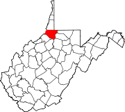 | |
| Towns | ||
| CDPs | ||
| Unincorporated communities |
| |
| Ghost towns | ||
| Footnotes | ‡This populated place also has portions in an adjacent county or counties | |