
The Marais: Difference between revisions
→Jewish community: Deleted spam and POV |
→Today's Marais: Improved |
||
| Line 43: | Line 43: | ||
The neighbourhood has experienced a growing [[gay]] presence since the 1980s, as evidenced by the existence of many gay cafés, nightclubs, cabarets and shops. These establishments are mainly concentrated in the southwestern portion of the Marais, many on or near the streets Sainte-Croix de la Bretonnerie and rue des Archives. |
The neighbourhood has experienced a growing [[gay]] presence since the 1980s, as evidenced by the existence of many gay cafés, nightclubs, cabarets and shops. These establishments are mainly concentrated in the southwestern portion of the Marais, many on or near the streets Sainte-Croix de la Bretonnerie and rue des Archives. |
||
The Marais is also known for the |
The Marais is also known for the Chinese community it hosts. The community began to appear during [[World War I]]. At that time, France needed workers to replace its at-war soldiers and China decided to send a few thousand of its citizens on the condition that they would not take part of the war. After the 1918 victory, some of them decided to stay in Paris, specifically living around the current rue au Maire. Today, most work in [[jewelery]] and leather-related products. The Marais' Chinese community has settled in the north of the district, particularly in the surrounding of [[Place de la République]]. Next to it, on the [[rue du Temple]], is the Chinese Church of Paris. |
||
Other features of the neighbourhood include the [[Musée Picasso]], the house of [[Nicolas Flamel]], the [[Musée Cognacq-Jay]], the [[Musée Carnavalet]] and the new and very popular [[Café Charlot]]. |
Other features of the neighbourhood include the [[Musée Picasso]], the house of [[Nicolas Flamel]], the [[Musée Cognacq-Jay]], the [[Musée Carnavalet]] and the new and very popular [[Café Charlot]]. |
||
Revision as of 10:50, 22 July 2013
This article needs additional citations for verification. (October 2009) |


Le Marais ("The Marsh", French pronunciation: [maʁɛ]) is a historic district in Paris, France. Long the aristocratic district of Paris, it hosts many outstanding buildings of historic and architectural importance. It spreads across parts of the 3rd and 4th arrondissements in Paris (on the Rive Droite, or Right Bank, of the Seine).
History
Paris aristocratic district
In 1240 the Order of the Temple built its fortified church just outside Paris's walls, in the northern part of the Marais. The Temple turned the district into an attractive area, and many religious institutions were built nearby: the des Blancs-Manteaux, de Sainte-Croix-de-la-Bretonnerie and des Carmes-Billettes convents, as well as the church of Sainte-Catherine-du-Val-des-Écoliers.
During the mid-13th century, Charles I of Anjou, King of Naples and Sicily, and brother of King Louis IX of France built his residence near the current n°7 rue de Sévigné.[1] In 1361 the King Charles V built a mansion known as the Hôtel Saint-Pol in which the Royal Court settled during his reign as well as his son's.
From that time to the 17th century and especially after the Royal Square (Place Royale, current place des Vosges) was designed under King Henri IV in 1605, the Marais was the French nobility's favorite place of residence. French nobles built their urban mansions there[2] such as the Hôtel de Sens, the Hôtel de Sully, the Hôtel de Beauvais, the Hôtel Carnavalet, the Hôtel de Guénégaud, and the Hôtel de Soubise.
Jewish community
After the nobility started to move to the Faubourg Saint-Germain, the district became a popular and active commercial area, hosting one of Paris' main Jewish communities. At the end of the 19th century and during the first half of the 20th, the district around the rue des Rosiers, referred to as the "Pletzl", welcomed many Eastern European Jews (Ashkenazi) who reinforced the district clothing specialization. But, during World War II the Jewish community was targeted by the Nazis who were occupying France.
The rue des Rosiers is still a major centre of the Paris Jewish community, which has made a renewal since the 1990s. Public notices announce Jewish events, bookshops specialize in Jewish books, and numerous restaurants and other outlets sell kosher food.
The synagogue on 10 rue Pavée is not far from rue des Rosiers. It was designed in 1913 by Art Nouveau architect Hector Guimard, who designed several Paris Metro stations.
Post-war rehabilitation
By the 1950s, the district had become a working-class area and most of its architectural masterpieces were in bad state of repair. In 1964, General de Gaulle's Culture Minister Andre Malraux made the Marais the first secteur sauvegardé (literally safeguarded sector). These were meant to protect and conserve places of special cultural significance. The following decades, the government and the Parisian municipality have led an active restoration and Rehabilitation Policy.
The main Hôtels particuliers have been restored and turned into museums: the Hôtel Salé hosts the Picasso Museum, the Hôtel Carnavalet hosts the Paris Historical Museum, the Hôtel Donon hosts the Cognac-Jay Museum etc. The site of Beaubourg, the western part of Marais, was chosen for the Centre Georges Pompidou, France's national Museum of Modern Art and one of the world's most important cultural institutions. The building was completed in 1977 with revolutionary architecture by Renzo Piano and Richard Rogers.
Today's Marais
The Marais is now one of Paris' main localities for art galleries. Following its rehabilitation, the Marais has become a fashionable district, home to many trendy restaurants, fashion houses, and hype galleries.
The neighbourhood has experienced a growing gay presence since the 1980s, as evidenced by the existence of many gay cafés, nightclubs, cabarets and shops. These establishments are mainly concentrated in the southwestern portion of the Marais, many on or near the streets Sainte-Croix de la Bretonnerie and rue des Archives.
The Marais is also known for the Chinese community it hosts. The community began to appear during World War I. At that time, France needed workers to replace its at-war soldiers and China decided to send a few thousand of its citizens on the condition that they would not take part of the war. After the 1918 victory, some of them decided to stay in Paris, specifically living around the current rue au Maire. Today, most work in jewelery and leather-related products. The Marais' Chinese community has settled in the north of the district, particularly in the surrounding of Place de la République. Next to it, on the rue du Temple, is the Chinese Church of Paris.
Other features of the neighbourhood include the Musée Picasso, the house of Nicolas Flamel, the Musée Cognacq-Jay, the Musée Carnavalet and the new and very popular Café Charlot.
Notable residents
- Maximilien de Béthune, duc de Sully
- Urbain de Maillé-Brézé
- Armand de Vignerot du Plessis
- Princes of Rohan Soubise
- Catherine de Vivonne, marquise de Rambouillet
- Marie de Rabutin-Chantal, marquise de Sévigné
- Maximilien Robespierre
- Victor Hugo
- John Galliano
- Jack Lang
- Dominique Strauss-Kahn and Anne Sinclair
Places and monuments of note
- Church Saint-Merri
- Church Notre-Dame-des-Blancs-Manteaux
- Church of Saint-Paul-Saint-Louis
- Church of St-Gervais-et-St-Protais
- Church of Saint-Nicolas-des-Champs
- Hôtel de Sully
- Hôtel d'Aumont
- Hôtel de Beauvais
- Hôtel de Sens
- Hôtel d'Angoulême Lamoignon (housing the Bibliothèque Historique de la Ville de Paris)
- Place des Vosges, including the home of Victor Hugo and Café Ma Bourgogne
- Musée Cognacq-Jay
- Musée Picasso
- Musée des Arts et Métiers
- Musée d'Art et d'Histoire du Judaïsme (housed in the Hôtel de Saint-Aignan)
- National Archives, including the Hôtel de Soubise and Hôtel de Rohan
- Carnavalet Museum
- Pletzl, the Jewish quarter
-
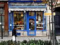
 Jo Goldenberg's Jewish delicatessen on the rue des Rosiers (now defunct)
 -
 Chez Marianne, a Jewish restaurant in Le Marais
 -
 Restaurant Pitchi Poï in the predominately Jewish Pletzl quarter
 -
 Murciano Jewish bakery in the rue des Rosiers
 -
 Hôtel de Sens
 -
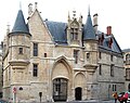
 Hôtel Soubise
 -
 Maison de Jean Herouet
 -
 Entrance of l'Hôtel d'Almeras
 -
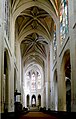 Interior of Saint-Gervais-et-Saint-Protais Church
 -
 Saint-Paul Saint-Louis Church
 -
 Hôtel Salé (Picasso Museum)
 -
 Place des Vosges
 -
 Medieval cellar of the Hôtel de Beauvais
 -
 Medieval houses in rue Miron
 -
 Reading room in the Bibliothèque Historique de la Ville de Paris (City of Paris History Library)
 -
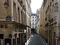 View of rue Aubriot

_01.jpg)


.JPG)


References
- ^ This hôtel remained until 1868. The rue du Roi-de-Sicile is named after it.
- ^ Hôtels particuliers in French
External links
- Magical Marais: Place des Vosges, rue du Bourg-Tibourg, etc. Tour the neighbourhood in photographies and descriptions
- Le Marais
- Le Marais: The Indifferent Ghetto Article about Le Marais as the gay neighbourhood of Paris
- Gay Paris: English speaking gay walks in Paris
- ParisMarais.com: the official guide, partner of the Paris Tourist Office
- Le Marais photos
- Marais district Photographs
- My Gay Paris The latest news on Paris and Le Marais with a gay perspective