
Gaustatoppen: Difference between revisions
No edit summary |
No edit summary |
||
| Line 46: | Line 46: | ||
* [http://www.nxtri.com/ Norseman Xtreme Triathlon] |
* [http://www.nxtri.com/ Norseman Xtreme Triathlon] |
||
* {{cite web|title=Krever hele Gaustatoppen for 7500 kroner|url=http://www.dn.no/forsiden/naringsliv/article2681956.ece|date=2013-09-14|trans_title=Demanding the entire Gaustatoppen for Norwegian kroner 7500}} |
* {{cite web|title=Krever hele Gaustatoppen for 7500 kroner|url=http://www.dn.no/forsiden/naringsliv/article2681956.ece|date=2013-09-14|trans_title=Demanding the entire Gaustatoppen for Norwegian kroner 7500}} |
||
* {{cite web|title=Krever tilbake Gaustatoppen|url=http://www.nrk.no/ostafjells/telemark/gjenkjopet-verdt-7500-kroner-1.11242520|publisher=[[NRK]]|date=2013-09-15|trans_title=Demanding the return of Gaustatoppen}} |
|||
[[Category:Mountains of Telemark]] |
[[Category:Mountains of Telemark]] |
||
[[Category:Tinn]] |
[[Category:Tinn]] |
||
Revision as of 16:06, 15 September 2013
| Gaustatoppen | |
|---|---|
 | |
| Highest point | |
| Elevation | 1,883 m (6,178 ft) |
| Prominence | 950 m (3,120 ft)[1] |
| Isolation | 94.8 to 95 km (58.9 to 59.0 mi) |
| Listing | 8 at List of highest points of Norwegian counties |
| Coordinates | 59°51′14.9″N 8°39′01.2″E / 59.854139°N 8.650333°E |
| Geography | |
| Location | Tinn, Telemark, Norway |
| Topo map | 1614 IV Rjukan |
| Climbing | |
| First ascent | 1810 by Jens Esmark |
| Easiest route | Elevator system inside mountain |

Gaustatoppen is the highest mountain in the county Telemark in Norway. The view from the summit is impressive, as one can see an area of approximately 60,000 km², one sixth of Norways mainland. There is an elevator system inside the mountain, built for military purposes, and is now a tourist atracttion. This ascends from the base of the mountain almost to the summit. The mountain is popular for downhill skiing in winter, and competitions have been held on its slopes. These competitions include the "Norseman triathlon", 'Norseman Xtreme Triathlon, billed as "the world's most brutal iron-distance triathlon. It starts in Eidfjord and finishes at the top of Gaustatoppen." The summit is accessible on foot in the summer, on a rocky pathway of medium difficulty, although the southern side of the mountain is very dangerous and inaccessible. The wreckage of an airplane crash lies there, as it is too difficult to remove it.
The name
The first element is Gausta, the name of the whole mountain, the last element is the finite form of topp m 'top, summit'. The name Gausta is probably a shortened form for *Gaustafjell (Gausta mountain), because Gausta originally was the name of a farm beneath the mountain. (For the same development se Dovre.) The Old Norse form of the name was maybe *Gautstǫð, the name is then a compound of gaut f 'flooded place', and stǫð f 'stead, landing place for boat'. (The farm lies at Rjukan river.)
Railway
Inside the mountain there is a railway (with an electric locomotive) that cost one million US dollars to build from 1954 to 1959.[2]
-
 Gaustatoppen and Rjukan
 -
 Gaustatoppen painted by Peder Balke around 1858
 -

-
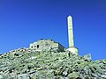 Summit installation
 -
Gaustatoppen 2012
-
Gaustatoppen 360 degree photo


See also
References
External links
- Rjukan Tourist Information
- Norseman Xtreme Triathlon
- "Krever hele Gaustatoppen for 7500 kroner". 2013-09-14.
{{cite web}}: Unknown parameter|trans_title=ignored (|trans-title=suggested) (help) - "Krever tilbake Gaustatoppen". NRK. 2013-09-15.
{{cite web}}: Unknown parameter|trans_title=ignored (|trans-title=suggested) (help)
This Telemark location article is a stub. You can help Wikipedia by expanding it. |