
Talk:Control of cities during the Syrian civil war: Difference between revisions
m Signing comment by 80.184.67.215 - "→why Flitah change to red to contested ?: " |
|||
| Line 925: | Line 925: | ||
They don't, but they control the bases. Stop crying that your precious dictatorship forces have lost a couple of bases. <span style="font-size: smaller;" class="autosigned">— Preceding [[Wikipedia:Signatures|unsigned]] comment added by [[Special:Contributions/177.204.47.29|177.204.47.29]] ([[User talk:177.204.47.29|talk]]) 22:34, 28 August 2014 (UTC)</span><!-- Template:Unsigned IP --> <!--Autosigned by SineBot--> |
They don't, but they control the bases. Stop crying that your precious dictatorship forces have lost a couple of bases. <span style="font-size: smaller;" class="autosigned">— Preceding [[Wikipedia:Signatures|unsigned]] comment added by [[Special:Contributions/177.204.47.29|177.204.47.29]] ([[User talk:177.204.47.29|talk]]) 22:34, 28 August 2014 (UTC)</span><!-- Template:Unsigned IP --> <!--Autosigned by SineBot--> |
||
That dictatorship gave free religion, healthcare and security to Syria you fucking braindead. Cause shaira law with mass beheadings and crucifying shias is not dictatorship right? shitface |
|||
Revision as of 08:35, 29 August 2014
| This is the talk page for discussing improvements to the Control of cities during the Syrian civil war article. This is not a forum for general discussion of the article's subject. |
Article policies
|
| Find sources: Google (books · news · scholar · free images · WP refs) · FENS · JSTOR · TWL |
| Archives: Index, 1, 2, 3, 4, 5, 6, 7, 8, 9, 10, 11, 12, 13, 14, 15, 16, 17, 18, 19, 20, 21, 22, 23, 24, 25, 26, 27, 28, 29, 30, 31, 32, 33, 34, 35, 36, 37, 38, 39, 40, 41, 42, 43, 44, 45, 46, 47, 48, 49, 50, 51, 52, 53, 54, 55, 56, 57, 58, 59, 60, 61, 62, 63, 64, 65Auto-archiving period: 14 days |
| This page is not a forum for general discussion about Control of cities during the Syrian civil war. Any such comments may be removed or refactored. Please limit discussion to improvement of this article. You may wish to ask factual questions about Control of cities during the Syrian civil war at the Reference desk. |
| This article is of interest to the following WikiProjects: | |||||||||||||||||||||||||||||||||||||||||||||
| |||||||||||||||||||||||||||||||||||||||||||||


.svg)
| To help centralise discussions and keep related topics together, Template talk:Syrian Civil War detailed map redirects here. |
Template:Syrian Civil War sanctions
|
Index 1, 2, 3, 4, 5, 6, 7, 8, 9, 10 |
|
This page has archives. Sections older than 14 days may be automatically archived by Lowercase sigmabot III when more than 4 sections are present. |
Roads
Shouldn't this map show at least the major roads and railways? After all, maneuver is critical in warfare, and that would explain more why this or that city or village is strategic. — Preceding unsigned comment added by 24.8.182.120 (talk)
- Absolutely. Someone please create a version of the base Syria location map with those features drawn. Alternatively, we need a picture file that has syria roads on it and nothing else. I can then use the "overlay_image =" parameter in the "Template:Location map+" to overlay that "road file" on top of our map. For an example of the result of this parameter, see a "Location map+" where a picture file with arrows was overlayed on top of it. Unfortunately, i don't know how to create picture files. If anyone can create such a file (same size as our map; with a transparent background) and put it in commons, then i can overlay it on top of our map. Tradediatalk I brought this back from archives as this is still an ongoing issue. And while we are at this, it would be good to also draw Lake Jabbūl Tradediatalk
- I agree that adding some of the most important highways to the map would make it more useful. It would have to be done delicately, because it could quickly make the map very cluttered. Looking at road maps of Syria, I would suggest something showing a few major highways, along the lines of this [1] (scroll down slightly), rather than something more like this [2], which would overwhelm the map. Hulahoop122 (talk)
- Good idea. Between those 2 examples, the difference seems more how the roads are drawn (thin red lines vs. wide light brown lines), than the number of roads. In some areas, there seems to be more roads on the first map with the roads in red.
- Note that our map is bigger, so we could probably place more roads (if appropriate) without problem. In some areas there are many alternative roads allowing easy passage around the main routes, so it might be a good idea to indicate that.
- With a good source map with the roads already on it (and not too many complicated things in the same colour), I could produce the road overlay. The colour of the roads could be changed to whatever you like.
- There is a map on my computer that might be good, with many roads, except it could be as much as 20 years old. (The latest date on the map is a 1994 border treaty.) It is better to have something not long before the civil war started.
- According to my map, most of lake Jabbul is dry much of the year. (All except the north-west corner.) It also has rivers and railways, which might be interesting to show. (the roads, water, and railways could be put on separate layers so as to be easier to maintain, if necessary. Not hard since they are all different colours.) André437 (talk)
- If you have the skills to put that map layer together, that would be great. You could post it on a test page, just as you did with all of the conflict icons you created, and see how the community reacts. Hulahoop122 (talk)
- Ok, as I have time. It could take a while, since I will have to use google maps or equivalent to fill in the few places where a small window overlay covers roads, etc in some areas, and also clean up any stray marks I find. (There are a lot of annotations, but mostly outside Syria.)
- I'll also have to adjust the scale and align it, which will be the most difficult part.
- I'll put the roads/water/railways in separate layers initially as well. Easy to do since they are separate colours. That way it will be really quick to modify (or remove) one without affecting the others.
- That icon project helped remind me of a few tricks with the software I use. (gimp)
- BTW, I have an unrelated idea for locations contested from one side only : using a semicircle open on the opposite side. And for truces, using a broken outside circle, instead of a continuous one. Just mentioning it as something to think about.
- I'll keep you posted :) André437 (talk)
- If you have the skills to put that map layer together, that would be great. You could post it on a test page, just as you did with all of the conflict icons you created, and see how the community reacts. Hulahoop122 (talk)
- This section disappeared for a while and I became occupied elsewhere, but my map turned out to be so overwritten with place names so as to be almost useless. Most roads, rivers, etc were obscured in many places. It would be faster to draw features freehand using google maps in satellite mode. Not one of my talents. So I can't help much with that.
- I've noticed that some waterways have been added. It looks really nice. André437 (talk)
Deir Ez Zor contryside
SOHR reported that the rebels took control of many villages after clashes against ISIS https://www.facebook.com/syriahroe/posts/536128479828828 waiting for more sources FS1991
Khalfatli
According to SOHR, this border town is currently controlled by ISIS. https://www.facebook.com/photo.php?fbid=10152562069038115
IS in Damascus Pocket
According to AP -citing SOHR- the IS controls parts of Damascus pocket. They are now in "Al-Hajar Al-Aswad, Tadamon and Qadam in southern Damascus" https://uk.news.yahoo.com/syria-rebels-press-offensive-against-jihadists-near-damascus-110556227.html To have an accurate map of greater Damascus, should the Damascus map be altered for part of the green pocket to be black? It is fascinating to see this map develop and how much input people have put into it.
map changes
The map may soon need to add a new color. See news here on major split occurring within rebel ranks: http://www.stuff.co.nz/world/middle-east/10301860/Syrian-insurgents-seize-3-towns
Eastern Gouta
IS controls Mesraba in Eastern Gouta but I cannot see it on Damascus map — Preceding http://www.globaltimes.cn/content/870192.shtml
Tabqa Airbase
Fights in Tabqa Airbase per pro regimee [3] and other sources. Unconfirmed rumours that troops are being evacuated but base is currently contested in anyway.
Out of subject but why Ar Ruhayyat (above Raqqa city) still appears regimee held under IS siege? I haven't seen any reports that there is a government presence in the area anymore. Constantinos7 (talk) 01:29, 11 August 2014 (UTC)
Ar Ruhayyat is a left over of the recent past and should be turned black. For the base, a repelled attack is mentioned. I think no change is warranted at the moment. Paolowalter (talk) 09:56, 11 August 2014 (UTC)
http://www.independent.ie/world-news/jihadis-near-syria-army-base-30516471.html the villages/towns around the base should be made black. — Preceding unsigned comment added by 24.12.202.163 (talk) 20:56, 18 August 2014 (UTC)
https://www.youtube.com/watch?feature=player_embedded&v=bemiyHidGng Video Evidence: Tabqa Airbase will likely be cleared by tonight followed by an official IS announcement. Safe to say base is captured by this point. — Preceding unsigned comment added by 24.12.202.163 (talk) 19:35, 20 August 2014 (UTC)
http://www.dailymail.co.uk/news/article-2730733/ISIS-march-DESPITE-U-S-airstrikes-How-terror-group-expanding-thanks-lucrative-hostage-trade-capturing-swathes-territory-seizing-oil.html Villages around Tabqa Airbase are in IS hands. We should have official word soon that Tabqa Airbase has fallen once ISIS cleans up the tunnels. 184.20.122.52 (talk) 13:47, 21 August 2014 (UTC)
http://world.al-mustaqbal.net/islamic-state-storms-syrian-army-kurdish-militants-and-iraqi-sahawat/# Good as official confirmation. Tabqa Airbase has fallen to IS. It and surrounding towns should be changed to black. Assad no longer has a presence in Raqqa Province. Tgoll774 (talk) 03:27, 23 August 2014 (UTC)
- Your source it is pro IS source and he cant be use to displayed of IS advance. Hanibal911 (talk) 06:13, 23 August 2014 (UTC)
- IS not taken Tabqa Airbase clashes continue around Airbase.Reuters Hanibal911 (talk) 06:17, 23 August 2014 (UTC)
- Also today SOHR said that clashes still around Air Base and no confirmation from the reliable sources that IS captured the Tabqa Air Base.SOHR Hanibal911 (talk) 10:01, 23 August 2014 (UTC)
- IS not taken Tabqa Airbase clashes continue around Airbase.Reuters Hanibal911 (talk) 06:17, 23 August 2014 (UTC)
The base largely fell on the 21st, twitter feeds and pictures were posted before Twitter ban hammered them all, the following is what I have been able to save. https://twitter.com/isisnews4/status/502399762448924672/photo/1 https://twitter.com/YazidMuawiya/status/502510856731508736/photo/1 https://twitter.com/isisnews4/status/502125787906994177/photo/1 Main fighting is in the tunnels under the base and the remaining bunker with SAA trying to counter attack. Considering the size of the base, 6 klick by 5 klicks, its a large place to comb so the official word won't come till the final holdouts are dealt with. Tgoll774 (talk) 15:48, 23 August 2014 (UTC)
Some IS sources on Twitter said that they entred the airport and some buildings and a companie of Air Defense inside the airport have fallen.[4] 11:12, 23 August 2014 (UTC+1)
Tabqa Airport has fallen.[5] 12:30, 24 August 2014 (UTC)
http://www.middleeasteye.net/news/islamic-state-claim-control-tabqa-airbase-syria-805309165 Base has fallen to IS and officially confirmed by IS. But wait http://abcnews.go.com/International/wireStory/jihadis-part-syrian-air-base-25101754 states at least part of base has fallen if not all of it. Tgoll774 (talk) 13:11, 24 August 2014 (UTC)
- You must be joking! Why do you post here this garbage that is 100% is not a reliable source.
- https://news.yahoo.com/jihadists-enter-syria-military-airport-first-time-ngo-000006397.html Its official, even Syria has admitted it. Tgoll774 (talk) 14:30, 24 August 2014 (UTC)
IS takes over parts of Syrian air base but clashes continue.Reuters Hanibal911 (talk) 13:27, 24 August 2014 (UTC)
IS claims the airport to be taken 14:10, 24 August 2014 (UTC) [6]
- SOHR reported that the Islamic State took control almost completely over the Military Airport of al Tabaqa amid clashes with the regime forces in several points inside the airbase.SOHR Hanibal911 (talk) 17:23, 24 August 2014 (UTC)
North of Abu al-Duhur in SAA hands according to rebel source
Rebel source SOHR https://www.facebook.com/syriahroe/posts/566614470113562 in London report the east way from Abu al-Duhur is in SAA hands it confirmed the Air base it's not under siege anymore like was reported by Syrian official TV Reports in February 2014 http://en.wikipedia.org/wiki/Talk:Cities_and_towns_during_the_Syrian_Civil_War/Archive_19#Abu_al-Duhur_air_base_not_under_siege_anymore_since_mouths_ago.
Make East from Abu al-Duhur in SAA control (Not in conflict just on West side) — Preceding unsigned comment added by 190.203.244.2 (talk) 02:21, 11 August 2014 (UTC)
The SOHR source you mentioned provides no information about the surrounding of the base. I am not in favour of adding detailed symbols for sieging on one or more sides. It would bring to endless and useless discussions. The ring means vaguely "on the front line, enemy just outside" and it is often questionable and not really important. Paolowalter (talk) 09:56, 11 August 2014 (UTC)
The pro insurgent source confirmed the east from Abu al-Duhur is with Army pretense we should be put small red semi circle on west of Abu al-Duhur --Pototo1 (talk) 13:33, 11 August 2014 (UTC)
Twitter feeds state Tabqa Airbase has fallen, official word soon.Tgoll774 (talk) 02:05, 21 August 2014 (UTC)Tgoll774Tgoll774 (talk) 02:05, 21 August 2014 (UTC)
Hamadiya, Idlib countryside
This video http://www.liveleak.com/view?i=6b9_1407803091 claims, that the rebels have taken Hamadiya Syrian Army position in Idlib countryside. Any more sources for this? — Preceding unsigned comment added by 95.208.214.60 (talk) 19:01, 12 August 2014 (UTC)
I dunno bro the insurgents upload 500 + videos every day need to have at least one source different than insurgents videos --Pototo1 (talk) 04:13, 13 August 2014 (UTC)
I'm not saying we shouldn't take videos seriously, but not from liveleak... I found these 2 videos on Al Nusra YT channel, it says "captured" Al-Tarraf checkpoint in Idlib, and "captured" Al-Dahman checkpoint near al-Hamidiyah. Legit or not, I can't find them on map so do what ever you want. DuckZz (talk) — Preceding undated comment added 15:30, 13 August 2014 (UTC)
- SOHR confirmed that al-Hamedia and Wadi al-Deif camps in M'ara al-Nu'man countryside under control government troops but besieged the rebels.SOHR Hanibal911 (talk) 07:20, 17 August 2014 (UTC)
Names of some villages and towns
seems some one doing vandalism and delete parts of these towns in Hasakah https://www.facebook.com/syriahroe/posts/562706100504399 please relocated that --Pototo1 (talk) 04:11, 13 August 2014 (UTC)
- Often editor Tradedia revert editings because he believes that if the name of the object on the map and in the source does not match on 100% we do not need to edit this city or village. Here he revert my edit because he said that Al Marfu`ah is not the same as Al Ma’ruf and Ali al Fallah is not the same as Al Fallaha. But we all know that very often some of the sources including SOHR indicate the name of the towns or villages is not quite as it appears on the map. I think everyone will agree with me! Hanibal911 (talk) 06:57, 14 August 2014 (UTC)
- I understand that there are many different ways to transliterate an Arabic name into English. However, an Arabic speaker will recognize that Al Marfu`ah = مرفوعة is very different from Al Ma’ruf = معروف. Ma’ruf means “known”. On the other hand Marfu`ah means “raised”. Also, `Ali al Fallah = الفلاح علي is very different from Al Fallaha = فلاحة . Al Fallaha means the “woman farmer”. On the other hand `Ali al Fallah means “Ali the farmer”.
- Also, there is not just the name to take into account. You have to look at the geographic location. You put the dot for Al Marfu`ah based on geonames.org. However, you can see on the map that it must be a mistake, because at that location, there is no village, not even a house. It is literally in the middle of the desert!
- You had already put Al Slaleyyi & Al Homor in the wrong place and you were corrected by another editor. This should have told you that your work methodology has problems in it. The source said: “The Islamic battalions retreated from areas in the south- east of Al Hasaka city, where the regime forces advanced and took control over the villages of Al Homor, Al Slaleyyi, Al Fallaha, Al Ma’ruf and Al Maqbara reaching to the old junction of Al Shaddadi.” After we put on our map the correct location of Al Slaleyyi & Al Homor, you can see that the army advance is rather close to Hasaka city as the source indicated. The places where you put Al Marfu`ah & `Ali al Fallah are very far from them. Moreover, `Ali al Fallah is way south of Al Shaddadi, which is not at all consistent with the source. The army made an advance “reaching to the old junction of Al Shaddadi.”
- As of now, our map looks stupid with these 2 red dots deep in the middle of ISIS territory. Why would the army go to the middle of the desert at Al Marfu`ah where there is not even a house!? And do you think the army would be in `Ali al Fallah very deep into ISIS territory, and very far away from their supply lines?
- All the above elements clearly show that the 2 dots that are now on the map cannot be the villages that are talked about in the source. Also, I want to note that you were about to make the same mistake here: #al-Aziziyah and Al Hamidiyah. And you made the same mistake here and here. It is not enough to do a search on a name in a source and then pick a similar name and just put the dot on the map. We need to be more careful about the context and the geography. Tradediatalk 02:09, 16 August 2014 (UTC)
Sawran
Some pro opposition sources said that IS captured the city Sawran(Suran) in the Aleppo countryside.arabthomnessTahrirSy But I dont know we can use this data because they taken from Twitter. Waiting for your offers. Hanibal911 (talk) 08:57, 14 August 2014 (UTC)
- Pro-op eaworldview reports IS "were reported in Suran, east of Azaz, last night" http://eaworldview.com/2014/08/syria-daily-insurgents-doomed-aleppo/ Boredwhytekid (talk) 12:12, 14 August 2014 (UTC)
- SOHR said that violent clashes have occurred between IS fighters and the Islamic and rebel battalions in the vicinity of Ehtimlat village and the township of Soran E’zaz. But it is not clear exactly where the collision or in the Soran or Azaz or in the villages between the two cities. But i think that we need put green circle around the village Ehtimlat which now under IS control.source Hanibal911 (talk) 13:10, 14 August 2014 (UTC)
I agree. A green semi circle to the west of Suran is probably appropriate too Boredwhytekid (talk) 13:15, 14 August 2014 (UTC)
- Agree! But you can do it yourself or I do it? Hanibal911 (talk) 13:22, 14 August 2014 (UTC)
 Done I've added both Boredwhytekid (talk) 13:39, 14 August 2014 (UTC)
- Remains unclear the situation with the city Sawran(Soran). Here are the data that show that ISIS bombardment with mortars on Sawran(Soran).here Hanibal911 (talk) 15:04, 15 August 2014 (UTC)
It seems we jumped the gun. If they are bombarding it, Sawran(Soran) should be lime with a black ring to the East Boredwhytekid (talk) 15:06, 15 August 2014 (UTC)
- But taking into account all the data I think it would be better to note it as a contested. Hanibal911 (talk) 15:21, 15 August 2014 (UTC)
Tall Ma'ruf
Based on which source pro-Bashar editors changed Tall Ma'ruf to contested? Is it sourced?? Roboskiye (talk) 16:55, 14 August 2014 (UTC)
- You better indicate the source on the basis of which you marked the village Tall Ma'ruf under control by Kurds. And by the way, I never did not noted the village Tall Ma'ruf to contested. But these villages previously were contested between Kurds and IS.here Hanibal911 (talk) 17:12, 14 August 2014 (UTC)
- NO, my edit is already reverted to your unsourced version. It's YOUR job to provide a source which places Tal Maruf as contested. Roboskiye (talk) 17:17, 14 August 2014 (UTC)
- Because these villages previously have been marked as contested on based data from reliable sources. Hanibal911 (talk) 17:40, 14 August 2014 (UTC)
- Roboskiye was right I looked the history of map editing and found a mistake! On 13 July the editor Ahmetyal noted the village Tall Maruf to contested and also add the village Eastern Palestine and noted it as contested on based data the Kurdish source.here But he was wrong in the source did not said that in these villages clashes in the source only says that Islamic militants shelled the villages of heavy artillery and tanks. Hanibal911 (talk) 08:12, 15 August 2014 (UTC)
- Good. I'm still pretty sure there are no clashes in Tal Alo, Jaza and Tel Kocher. But unfortunately there are not many sources to clarify the current situation, with exception of pro-YPG websites. Roboskiye (talk) 08:48, 15 August 2014 (UTC)
- Roboskiye was right I looked the history of map editing and found a mistake! On 13 July the editor Ahmetyal noted the village Tall Maruf to contested and also add the village Eastern Palestine and noted it as contested on based data the Kurdish source.here But he was wrong in the source did not said that in these villages clashes in the source only says that Islamic militants shelled the villages of heavy artillery and tanks. Hanibal911 (talk) 08:12, 15 August 2014 (UTC)
- Because these villages previously have been marked as contested on based data from reliable sources. Hanibal911 (talk) 17:40, 14 August 2014 (UTC)
- NO, my edit is already reverted to your unsourced version. It's YOUR job to provide a source which places Tal Maruf as contested. Roboskiye (talk) 17:17, 14 August 2014 (UTC)
al-Aziziyah and Al Hamidiyah
Source Al Monitor said that IS captured the villages of al-Aziziyah and Al Hamidiyah but these villages located in the southeastern part of the Aleppo province here in area which under rebel control.Al Monitor And SOHR also said that IS captured the village Al Aziziyah.here Who has any suggestions on this issue! Hanibal911 (talk) 09:42, 15 August 2014 (UTC)
My bet is that they are talking about here http://wikimapia.org/#lang=en&lat=36.531812&lon=37.312240&z=15&m=b Boredwhytekid (talk) 12:13, 15 August 2014 (UTC)
- Yes you are right! Thanks to the editor Boredwhytekid we found the village al-Aziziyah but still we need to find the village Al Hamidiyah. Hanibal911 (talk) 12:22, 15 August 2014 (UTC)
Ayn al-Arab / Kobane
Can someone please take the villages out of the Euphrates and relocate them to the appropriate bank of the river? Boredwhytekid (talk) 12:42, 15 August 2014 (UTC)
- But they are so marked on the map.here Although I agree with you it is looks very strange! Hanibal911 (talk) 13:07, 15 August 2014 (UTC)
https://www.youtube.com/watch?v=2e58_kSeBIM Kobane is under siege and needs to be changed and more info is needed about this area. But I think all those Kurdish illages leading to Kobane have fallen. Tgoll774 (talk) 14:42, 21 August 2014 (UTC)
http://www.newsweek.com/2014/08/29/last-stand-kurdish-troopers-kobani-265522.html Some clarifications. Its clear though PYD is hiding serious losses. Tgoll774 (talk) 15:05, 21 August 2014 (UTC)
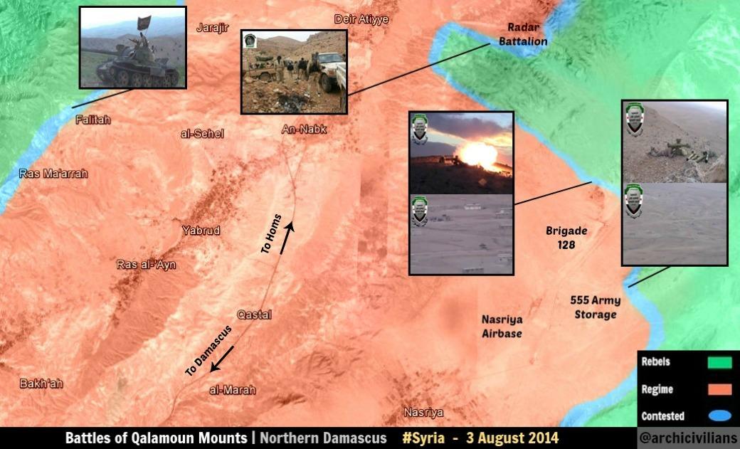
Ras al-Maarra, Qalamoun
This pro-gov't source shows rebels advancing towards Ras al-Maarra from the southwest https://twitter.com/PetoLucem/status/499490650812080129/photo/1. SOHR reports barrel bombing in the "wasteland of Ras al-Maarra" (to the southwest of the town) https://www.facebook.com/syriahroe/posts/568943429880666. Pro-gov't al-Wahda reports that an attack was repelled in Ras al-Maarra http://thawra.alwehda.gov.sy/_kuttab_a.asp?FileName=31590954220140813010445. Pro-op Qalamoun Media Center reports rebel advances in Ras al-Maarra https://www.facebook.com/Qalamon.MC9/posts/754689284595211. Pro-op eaworldview reports rebels took "two checkpoints and four barracks in Ras al-Maraa" http://eaworldview.com/2014/08/syria-daily-insurgent-counter-aleppo-defeats-victories-elsewhere-patchwork-war/.
Here is the town http://wikimapia.org/#lang=en&lat=33.998967&lon=36.555805&z=14&m=b. There's obviously some fighting going on around this place. I propose that Ras al-Maarra be added as a red dot, and a lime semi-circle ONLY to the southwest of Ras al-Maarra. Boredwhytekid (talk) 13:18, 15 August 2014 (UTC)
Not how it works. The circle is there if there is clashes on the outskirts of the town, the town is besieged or if the town is shelled. None of this is occurring. Source talks about fighting in the wastelands of the town, which as far as we can know is kilometers away (large desolate area west and southwest of it) and not in the outskirts. And the Qalamoun media center and eaworldview are excluded as sources by default from the start. And that Peto Lucem map shows the rebels a good half a dozen or more kilometers west of the town. EkoGraf (talk) 13:30, 15 August 2014 (UTC)
The pro-gov't al-Wahda report meets your criteria. As does a SANA report from late July http://www.sana.sy/en/?p=8170 stating the army "continued operations in.. the towns of al-Mesherfeh and Ras al-Maarra, killing several terrorists" - that's SANA talking about clashes IN the town last month.
Technically, by the editing rules, that SANA report is the latest valid source we have as to who controls the town - and by that logic we should add it as contested. But that isn't true, so I am proposing we do the reasonable thing and add it as the situation on the ground truly is.
It is gov't held and there are clashes on the outskirts to the southwest now.. Boredwhytekid (talk) 14:05, 15 August 2014 (UTC)
- Now in this area there goes a joint operation of the Syrian and the Lebanese army with the support of Hezbollah. And the rebels basically commit attacks hit and run! If in a situation with the city of Assal Al Warad pro government map showed that the clashes go is not far from the city. But in a situation with the city of Ras al Mara map showed that the clashes go are far from the city. Hanibal911 (talk) 14:16, 15 August 2014 (UTC)
Look, that SANA report is the latest one we have to validate the situation in Ras al-Maarra - I can add it as contested on the basis of that source and be 100% in the right as goes the editing rules. I am trying to compromise and show the truth. Boredwhytekid (talk) 14:22, 15 August 2014 (UTC)
- But pro opposition source also showed that on 3 August that clashes go outside the city.here and pro government source on 13 August showed that clashes go in few miles from the city.here Hanibal911 (talk) 14:49, 15 August 2014 (UTC)
But that pro-rebel map shows them right outside of the city, and the pro-gov't one shows them attacking towards it. Both support that it's gov't held, and the front line is on the outskirts to the southwest. 146.184.160.23 (talk) 14:59, 15 August 2014 (UTC)
The SANA report says they are conducting operations in the town, which can as well mean they are conducting raids on rebel hideouts and in the process killing or arresting insurgent operatives. These are insurgents after all who work undercover from the underground. The report does not say at any time that there is an ongoing battle for the town, while we have SOHR itself saying and the pro-rebel map showing the town is government-held. EkoGraf (talk) 15:47, 15 August 2014 (UTC)
- I agree with EkoGraf. Hanibal911 (talk) 15:55, 15 August 2014 (UTC)
Kurdish villages on north Raqqa province
Pro-opposition Kurdish source claimed that villages of Kendal, Bir kino, Koperlik, Hawalik, Koshkar, Hashasho and Huriya, west of Tel Abyad under control by YPG.Ara News Some of these villages now noted under control by IS. Somebody of the editors has more data about the situation in these villages and who actually controls them? Because the Kurds claim that they control the area where located these villages and are preparing for an extended military operation against IS militants to regain control over the city Tel Abyad. Hanibal911 (talk) 13:53, 15 August 2014 (UTC)
Mare' / Marea, Aleppo
On what basis is Mare' / Marea encircled by the IS? If it's being shelled, it's only from the east, so that's what the black circle should indicate. Boredwhytekid (talk) 14:18, 15 August 2014 (UTC)
- SOHR said that ISIS targeted town Mare' with mortars, reports of wounding a child, a man was killed by clashes against ISIS around Mare'.source Hanibal911 (talk) 14:54, 15 August 2014 (UTC)
Would you move the black circle to indicate that the IS is only attacking from the East? Boredwhytekid (talk) 15:03, 15 August 2014 (UTC)
Updated Meliha in Damascus map
News are emerging from a SAA capture of Al-malelah from the FSA. In some days it will be corroborated by News Agencies and Sohr. I will Keep an eye on it.200.48.214.19 (talk) 17:38, 14 August 2014 (UTC)
https://translate.googleusercontent.com/translate_c?depth=1&hl=es&ie=UTF8&prev=_t&rurl=translate.google.com&sl=ar&tl=en&u=http://syriahr.com/index.php%3Foption%3Dcom_news%26nid%3D22006%26Itemid%3D2%26task%3Ddisplaynews&usg=ALkJrhgisVZk-A3Z5BXDiv4C1Y7bHLHWRA200.48.214.19 (talk) 17:41, 14 August 2014 (UTC)
- Already confirmed by SOHR. EkoGraf (talk) 19:13, 14 August 2014 (UTC)
Dude if SOHR (No reliable Source) claim any bullsh1t you go fast in fews second to edit their claim lol but if you get huge evidences from others sources you did nothing after 24+ hours
alikhbaria TV Al Madayeen TV SANA SAMA TV NDF Press Office
Lebanon Al Jadeed Lebanon Al Madayeen 1 Lebanon Al Madayeen 2 Inside the Insurgent Meliha Tunnels
AFP Gulf Times Los Angeles Times
More sources http://www.lbcgroup.tv/news/172115/syrian-army-takes-town-outside-damascus-report http://uk.reuters.com/article/2014/08/14/uk-syria-crisis-town-idUKKBN0GE0MN20140814 --Pototo1 (talk) 15:35, 15 August 2014 (UTC)
village B'eden in Aleppo province
IS have taken over the village of B'eden near al-Ra'ii town which is also under control by IS in the northern countryside of Aleppo near Syria -Turkey borders.SOHR Who knows where located this village on the map. Hanibal911 (talk) 15:44, 15 August 2014 (UTC)
real name is bagheden. location: http://wikimapia.org/#lang=tr&lat=36.656318&lon=37.303090&z=15&m=b195.155.232.224 (talk) 17:04, 15 August 2014 (UTC)
Al-Masrab in Deir ez Zor province
Opposition news agency, said the Islamic State continued its assault village Al Masrab, a third village controlled by the regime in the western countryside. But source not say that the militants Islamic State captured the village. Do someone else from editors have data about the situation in this village.The Sacramento BeeMiami HeraldMc Clatchy Dc Hanibal911 (talk) 17:28, 15 August 2014 (UTC)
- SOHR last month - mentions it in the 2nd line https://www.facebook.com/syriahroe/posts/556874567754219 Boredwhytekid (talk) 17:45, 15 August 2014 (UTC)
- But SOHR reported about situation in this village on 18 July. But this sources The Sacramento BeeMiami HeraldMc Clatchy Dc claimed on 22 july that Islamic State not yet captured this village. And they got this information from the opposition news agency. So that their information is newer and more urgent. Hanibal911 (talk) 18:05, 15 August 2014 (UTC)
- This dubious blog source is the only other reference I've come across http://malcolmxtreme.wordpress.com/2014/08/11/8112014/ Boredwhytekid (talk) 18:15, 15 August 2014 (UTC)
Al kindi hospital
According to local and army sources ,saa recapture al kindi hospital https://www.facebook.com/alepponews1/posts/936490863044432 https://www.facebook.com/ktaybalbath3/posts/1523372341227043 https://www.facebook.com/ANNaleppo/posts/714357131946972 https://www.facebook.com/2.Network.Aleppocountryside.89/posts/858921430785774 https://www.facebook.com/page.F.S.N.N/posts/705793449457702
I think we need to pro opp. source to confirmed it.195.155.232.224 (talk) 18:32, 15 August 2014 (UTC)
- Syrian Army regained control of Al-Kindi Hospital.Al-Masdar News Hanibal911 (talk) 19:34, 17 August 2014 (UTC)
Hama province villages and cities turned into government-held en-masse
Why alot of towns were changed to government-held. Alhanuty (talk) 21:13, 15 August 2014 (UTC)
- Said what one specific?
- Your reputation here is not good anyway you usually made a lot vandalism on map - You put all Hasakah city on Yellow when extensive parts of that are now is under Government control.. --Pototo1 (talk) 00:42, 16 August 2014 (UTC)
- hahahahah,really,i used reliable sources when making that edit, also to mention the YPG controls most of the city,the government controls only the center. Alhanuty (talk) 01:02, 16 August 2014 (UTC)
- alot of towns and cities turned red including Junaynah, Tulaysiyah, Hamamiyat, Qaser al-Mukharam, Shaatah, Fan ash Shamali, al-Zughbah,Hamamiyat,jalma,tal malh. huwayjah and huwash and jubyan contested without any proof.Alhanuty (talk) 01:07, 16 August 2014 (UTC)
- Yes, many villages changed back to regime hands. They are rebel held. — Preceding unsigned comment added by 177.97.161.17 (talk) 01:40, 16 August 2014 (UTC)
- This confirmed pro opposition source.here Hanibal911 (talk) 05:35, 16 August 2014 (UTC)
- Alhanuty you do not like the situation when some one edited in favor of the government even if it confirms the source of the opposition but you never opposed when some one edited in favor of the rebels, even when this was done using not reliable sources (blogs, pro opposition source or messages from twitter)I know that you are 100% supported the rebels and you do not make edits in favor the army, unlike other editors of like me or EkoGraf,HCPUNXKID or even editor Boredwhytekid with whom I sometimes have disputes but for the most part he good editor. Hanibal911 (talk) 06:05, 16 August 2014 (UTC)
- This confirmed pro opposition source.here Hanibal911 (talk) 05:35, 16 August 2014 (UTC)
but there wasn't any news that assad recaptured any town or village in hama,syracuse's map looks to be outdated,so i suggest to return back to the pro-government map and reliable sources.Alhanuty (talk) 16:37, 16 August 2014 (UTC)
- But pro-government map also can be wrong because there were no reports from any reliable sources that the rebels captured these villages. Hanibal911 (talk) 17:42, 16 August 2014 (UTC)
I agree with haniball.And first of all ,YPG doesnt control most of the hasakah .YPG spokesman say about hasakah: '...any claims that the Syrian regime has handed over areas to the YPG forces is untrue.' source: http://aranews.net/2014/08/ypg-spokesman-cooperation-syrian-regime-logical-current-conditions/ 2-About hama ,regime captures this villages in 2013 .And rebels didnt control this villages after that. source: http://breakingnews.sy/en/article/18550.html .Just some map from twitter shows this villages under rebel control which is not true. Give me one source (not from twitter) about this villages under rebel control.And if you dont like the map , go follow cedric labrousse , thomas van linge , archicivilians or other bs maps.212.252.215.156 (talk) 06:44, 16 August 2014 (UTC)
- Also here another pro opposition source showed that area which located these villages (Junaynah, Tulaysiyah, Hamamiyat, Qaser al-Mukharam, Shaatah, Fan ash Shamali, al-Zughbah,Hamamiyat) under control by Syrian troops.here Hanibal911 (talk) 07:09, 16 August 2014 (UTC)
that is outdated,and the publisher has published a newer map showing them under rebel control.here.Alhanuty (talk) 18:06, 16 August 2014 (UTC)
i am really having doubts on syracuse's map.Alhanuty (talk) 18:06, 16 August 2014 (UTC)
- But it is clearly showed that these villages under the control of the army. But this source pro opposition and cant be used to display the rebel advances. Also, you must remember that we have agreed to use pro government maps to display success rebels and pro opposition maps to show progress of the army. But only if on they clearly stated name the villages or city. In this case, my source of opposition is more correct. So when you changed some the villages of under control by the rebels on based the pro government map, you also have broken a rule because on this map some villages were not marked under rebel control. Hanibal911 (talk) 18:43, 16 August 2014 (UTC)
- Also this pro opposition map based on personal fantasies of her author, also data on this map not confirmed no one the reliable sources. Hanibal911 (talk) 18:49, 16 August 2014 (UTC)
https://www.facebook.com/SyrianPerspective2/photos/a.547771291935207.1073741828.546954078683595/733230620055939/?type=1&theater The most pro-regime page ever clearly putting those villages as rebel held. In AUGUST. NO CLASHES REPORTED EVEN IN REGIME MEDIA. CHANGE IT TO GREEN. — Preceding unsigned comment added by 177.97.161.17 (talk) 10:19, 16 August 2014 (UTC)
- This map dated on 2 August but here pro opposition map dated on 8 August and this source clearly showed that these villages under army control so that case closed. So my source is newer and showed more correct situation. Hanibal911 (talk) 10:35, 16 August 2014 (UTC)
Pro opp source shows this villages under Syrian Arab Army control.http://umap.openstreetmap.fr/fr/map/desyracuse-syria-civil-war-8-august-2014_14181#12/35.3265/36.8948 .In AUGUST.NO CLASHES REPORTED EVEN IN JIHADI MEDIA.92.44.170.102 (talk) 10:29, 16 August 2014 (UTC)
I think there is nothing to debate here really. We have a pro-opposition source [7] showing towns under Army control. And the link even has a date (8 August, just a week ago) so saying its out-dated isn't really an argument. EkoGraf (talk) 19:54, 16 August 2014 (UTC)
Yes, there isn't much to discuss, the villages are rebels held and that's it. Syrian Perspective posted a map showing this. They are a reliable pro-regime page. Basically I can make a twitter account, say I'm pro-opposition and claim that the regime has taken control of all of Aleppo and is case closed. Funny, you guys are incredible biased, I mean, REALLY F****** biased. A somewhat reliable pro-regime media post then as rebel held, they are rebel held, even if a 100% unreliable pro-opposition page claims otherwise. Is like Tall Brak for IS. One Kurdish source say IS-held. All others say YPG held, as YPG and IS battled there for weeks, YPG took control, and suddendly, without clashes, it misteriously goes to IS hands, even with all other Kurdish sources say it is still Kurdish. Pathetic. Your pro-regime thoughts are being put ahead of the real objective of this map, being a reliable source to people to see the situation in Syria. They are rebel held per a KNOWN pro-regime source, and regime held in UNKNOWN pro-opposition twitter page, so obviously, they are regime held. By that, while don't you change all of Syria to red? — Preceding unsigned comment added by 177.97.161.17 (talk) 20:29, 16 August 2014 (UTC)
- Stop talking nonsense and clog the talk page! Here pro opposition source on 8 August clearly shows that these villages under control government troops. And case closed. Hanibal911 (talk) 20:37, 16 August 2014 (UTC)
So some random unknown website can be used as a source to change half a dozen villages to regime-held just because it claims to be pro-opp? Are you serious with this crap?
Ayyash is under Army control many sources confirm that.
At least 9 sources and two visual evidences confirm Ayyash is under Army control = Source 1 (Official Syrian Government)Source 2Source 3Source 4Source 5Source 6Source 7Source 8Source 9Visual confirmation 1Visual confirmation 2
These evidences are very solid including the visual evidence, I no found a single reliable sources Ayyash is controlled by the IS Insurgents.
If Nobody provide information this must be change to red again. --Pototo1 (talk) 00:49, 16 August 2014 (UTC)
Pro-regime sources are not reliable. Here is a source which confirms ISIS control. http://www.mcclatchydc.com/2014/07/22/233999/islamic-state-thwarts-syrian-government.html Zenithfel (talk) 00:43, 21 August 2014 (UTC)
I agree with Zenithfel. Pro-regime sources (Press TV, SANA for example) are not to be used for regime advances. Only neutral sources (CNN, Al Jazzera, or other neutral media) are to be used for complete confirmation of either side (to show the appropriate rules pro-opp sources to show regime advances, pro-gov sources for opp advances). And please, Potato1, quit changing the dot many times (don't want to revert due to the 1RR policy and since you revered that change already. That would get me blocked). It would be a nuisance to the readers on Wikipedia. --Damirgraffiti |☺Say Yo to Me!☺ 03:15, 21 August 2014 (UTC)
And FYI, Potato1, these sources that you provided are pro-gov sources, and you are using them to display pro-Assad advances. I will revert it since that's not reliable to do so (look at the rules I provided above my post). Here's another source that confirmed that the gov attack failed and repelled by ISIS: http://www.sacbee.com/2014/07/22/6572119/islamic-state-thwarts-syrian-government.html (copied and pasted by source from here: http://www.mcclatchydc.com/2014/07/22/233999/islamic-state-thwarts-syrian-government.html). Both of these sources are reliable to use, but your pro-gov sources (don't even think about using pro-opp for opp advances either) sources, no way.--Damirgraffiti |☺Say Yo to Me!☺ 22:26, 22 August 2014 (UTC)
CAN YOU UPDATED THE FVCKING MLEIHA MAP ON DAMASCUS PLEASE?
WHAT THE HELL ARE YOU WAITING FOR UPDATED THAT ?
FSA BEHEADERS / AL QAEDA ARE NOT IN MLEIHA ANYMORE SAA CONTROLLED THIS FVCKING PLACE, IS TOTALLY IN RUINIS NOW BUT SAA CONTROLLED THAT RIGHT NOW.
UPDATED THIS CRAP
THANKS — Preceding unsigned comment added by 190.203.244.2 (talk) 02:35, 16 August 2014 (UTC)
Mayer town near nubbol and al zahra
Sohr says : Al Qodos Al Felastini Brigade, which is loyal to the regime, have arrested 2 fighters from the Islamic battalions after a military operation in the area of Mayer in the northern countryside. Mayer should be contested. Source: https://www.facebook.com/syriahroe/posts/57012412309593092.44.170.102 (talk) 12:56, 16 August 2014 (UTC)
Al Sheyha, Hama
This edit request to Module:Syrian Civil War detailed map has been answered. Set the |answered= or |ans= parameter to no to reactivate your request. |
Skynews reported that, if I heard it well, "Jaish el Herb" which means free army of Syria, took control over the villages or Al Sheyha and Kadaer(not located on this map) and are now very close to Hama airport, which they target with GRAD missiles. DuckZz (talk) 109.175.52.18 (talk) 14:01, 16 August 2014 (UTC)
according to sohr ,rebels retreat from al sheyha : https://www.facebook.com/syriahroe/posts/57006581643509492.44.170.102 (talk) 14:11, 16 August 2014 (UTC)
Right, nevermind then, can someone find the village Kader and maybe add it on the map? DuckZz (talk) — Preceding undated comment added 14:17, 16 August 2014 (UTC)
If to be more precise then rebels did not captured village Kader they invaded the village Arze.source Hanibal911 (talk) 14:38, 16 August 2014 (UTC)
- And also yesterday rebels not took village Al Sheyha they captured hill Tall Al Sheyha and village Arze.SOHRhere but today SOHR said that Islamic battalions and other rebels have pulled back from al-Shayha village and its hill after regime's bombardment.SOHR Hanibal911 (talk) 14:29, 16 August 2014 (UTC)
 Not done: please establish a consensus for this alteration before using the
 {{edit semi-protected}}template. Reading over this edit request, it seems the information is either unclear or already outdated. Each user has replied with a different change to be made and different sources. -- ferret (talk) 17:20, 22 August 2014 (UTC)
Mald, Aleppo
SOHR reports the IS overran "Mald near the town of Mare'" https://www.facebook.com/syriahroe/posts/570124123095930. Type "Mald" into geonames and it gives you Tall Malid, here http://www.geonames.org/maps/google_36.447_37.235.html, likewise for wikimapia http://wikimapia.org/#lang=en&lat=36.445942&lon=37.232331&z=15&m=b and mapcarta http://mapcarta.com/12690684. Mald = Tall Malid? Anyone have an objection to me adding this? Boredwhytekid (talk) 14:43, 16 August 2014 (UTC)
- In that same vein - can someone double check the position on Umm Hawsh? Tall Malid is to the NE of Umm Hawsh, but I just added it and it shows to the W instead. Boredwhytekid (talk) 14:55, 16 August 2014 (UTC)
- Three villages captured near Mare [8]. Maled, Hamidiyeh and Sonbol. EkoGraf (talk) 18:58, 16 August 2014 (UTC)
- Another source also confirmed that IS jihadists captured the village of Hamidieh.The Daily Star We need to find her on a map. Who knows where located this village? Hanibal911 (talk) 15:27, 17 August 2014 (UTC)
- Three villages captured near Mare [8]. Maled, Hamidiyeh and Sonbol. EkoGraf (talk) 18:58, 16 August 2014 (UTC)
Tabarat al Khashir
It is not clear who is control the village Tabarat al Khashir near Abu ad-Duhur Airbasebecause even pro opposition source notes it as contested. Some do not even have data on this village. Hey guys has another data about the situation in this village. Hanibal911 (talk) 15:05, 16 August 2014 (UTC)
Nothing is happening there, its not even contested, no need to add that village on the map. Also Tall Salmu can go just green as the village is not really surrounded and not contested ? DuckZz (talk) — Preceding undated comment added 15:12, 16 August 2014 (UTC)
- I asked experienced editors! So not need join the discussion especially if you cant to nothing specific to say. And we do not use data from opposition sources to display progress of the rebels. Hanibal911 (talk) 15:27, 16 August 2014 (UTC)
Army have presence in west of Abu ad-Duhur town (Town not base) according to insurgents sources https://www.facebook.com/syriahroe/posts/566614470113562 map should put a semi circle on west from Abu ad-Duhur town — Preceding unsigned comment added by 190.203.244.2 (talk) 05:03, 18 August 2014 (UTC)
Ayn Tarma
Syrian Army regained control of the village of Ayn Tarma in the East Ghouta.Al-Masdar News Need more informations about the situation in the area. Hanibal911 (talk) 19:42, 17 August 2014 (UTC)
Is youtube accepted as a source if you post a video uploaded on an official channel from a brigade, group, battalion etc. fighting in Syria ? DuckZz (talk) — Preceding undated comment added 10:52, 18 August 2014 (UTC)
- No! We can use as a sources video reports obtained from the reliable TV Channels such as (Al Jazeera, CNN, BBC and and other similar TV channels). All other amateur videos obtained from YouTube are not reliable sources. Also remember one of important rules of editing! We do not use pro government sources to display of army advances but also we dont use the pro opposition source to display the rebel advances. Hanibal911 (talk) 12:16, 18 August 2014 (UTC)
Khan Toman
SOHR reported that the hill of Khan Toman has been captured by the Syrian Army [9].The hill is south of Aleppo and has a strategic value.Daki122 (talk) 11:48, 18 August 2014 (UTC)
Hama province
Some edits ago, several villages east of Maan have gone red again. I searched the internet, and found a battle map of Syrian Perspective from 2 August (link: http://www.syrianperspective.com/2014/08/new-map-of-hama-offensive.html). We know Perspective to be verry much a pro-Assad group. Their battle map however cleary shows the villages in eastern Hama as being under rebel control. The frontline must be through the town of Fahn ash Shameli. Ours is way to the east of that town.
Also, several twitter sources claim fighting near Al-Safsafiah: https://twitter.com/markito0171/status/501370155512111104. This to corresponds with the map of Syrian Perspective. It seems the rebel controlled area in Hama is expaning, while we are unable to make the right edits due to strict source interpretation.
Before people begin to shout out: I KNOW twitter isn't a regular Wikipedia source, but does anybody have a better way to update this map in areas where no foreign journalists are allowed or can't come easily? Frankly, I don't think there is one. — Preceding unsigned comment added by 84.24.43.183 (talk) 17:33, 18 August 2014 (UTC)
I think Hanibal or someone else posted a pro-opposition map showing those villages under Government control, and as far as I remember it was a map from Thomas linge but he made an update 2 days ago showing north Hama the same as Petro Lucem DuckZz (talk) — Preceding undated comment added 20:23, 18 August 2014 (UTC)
Ghmam and Tardin, Latakia
The SAA is bombarding these towns https://www.facebook.com/syriahroe/posts/570450779729931. It would stand to reason that the rebels are in these towns. Obviously they are not bombarding themselves, yea? Tardin is way behind rebel lines in Latakia.. Boredwhytekid (talk) 18:06, 18 August 2014 (UTC)
SOHR also posted these two videos videos2 too saying rebels blew up a building in Kafraya and a tank in [http://wikimapia.org/#lang=en&lat=35.660295&lon=36.070991&z=15&m=b Tala DuckZz (talk)
- So that DuckZz you need stop publish this trash from YouTube. Amateur video from You Tube is not a reliable sourcehereHanibal911 (talk) 20:51, 18 August 2014 (UTC)
- Amateur video from You Tube is not a reliable source. And on 8 August pro opposition source showed that the village Ghmam under control the army.here Hanibal911 (talk) 20:42, 18 August 2014 (UTC)
Well I'm not using videos as a source for editing, where did I made a change according to them ? This is a talk page, and videos can be an indication to "keep an eye" on some place, that's it. By the way I'm not familiar with this @deSyracuse dude, why do you think he's a pro-opposition poster ? DuckZz (talk)
- First off with this agree many editors and secondly this source often use opposition data that to update the map. And here another pro opposition source showed that area where located this village now under control the army and clashes go near village Salma.source Hanibal911 (talk) 21:28, 18 August 2014 (UTC)
Al-Sher, Hama
According to SOHR and Petro, Al-Sher is contested. DuckZz (talk) — Preceding undated comment added 22:31, 18 August 2014 (UTC)
- Source said that violent clashes took place in al-Sher area but not in the city should read carefully the source. So I added a green circle around the village. And for the future carefully read your sources. Hanibal911 (talk) 06:05, 19 August 2014 (UTC)
Didn't saw the circles, it's a bit messy. DuckZz (talk) — Preceding unsigned comment added by 109.175.45.104 (talk) 15:24, 19 August 2014 (UTC)
- Look carefully! Hanibal911 (talk) 17:49, 19 August 2014 (UTC)
Updated Map
I found this New map as of August 15.Catlemur (talk) 22:02, 19 August 2014 (UTC)
- It is pro opposition map and we can use her that would show the army progress because we cant use pro opposition map to display the rebel advances. Just as we cant use the pro government map to display the army progress. Hanibal911 (talk) 22:21, 19 August 2014 (UTC)
This map was showing before this was created by FSA fan guy credibility is just bad.
I can draw a map publish that on my twitter account and claim that is a source. — Preceding unsigned comment added by 190.203.244.2 (talk) 01:57, 20 August 2014 (UTC)
I never claimed it to be the one and only true map.I just provided it in case it is useful.Calm down everyone.Catlemur (talk) 10:16, 20 August 2014 (UTC)
Atman in Daraa contested moderated beheaders claim they get CW attack there
Draw Atman town in Daraa and make that contested http://www.sana.sy/en/?p=10679 http://www.liveleak.com/view?i=282_1408459166 — Preceding unsigned comment added by 190.203.244.2 (talk) 00:52, 20 August 2014 (UTC)
- Atman is already shown contested on the Daraa city map Boredwhytekid (talk) 18:54, 20 August 2014 (UTC)
Date of last update
I noticed at the bottom of this map it says "This page was last modified on 31 July 2014 at 21:22" but I don't think that's correct. — Preceding unsigned comment added by 99.42.97.16 (talk) 17:17, 20 August 2014 (UTC)
Vandalism in Raqqah province map ?
User Zenithfel he claim he got this source http://live.aljazeera.com/Event/Syria_Live_Blog/124316675
But I think the map used before several pro insurgents sources including the SOHR to changes these towns to black to red
The rule is 1 source / Sources talking about specific town = Change the color that's Vandalism or honest edition ?
The user Zenithfel is doing a huge major edition on map (Change the color severals Towns) without sources talking about these towns -
He should post evidences town by town -Pototo1 (talk) 15:26, 21 August 2014 (UTC)
- Agree! Because source said that Tabqa air base the last army base in the region which under control the army.source Hanibal911 (talk) 15:45, 21 August 2014 (UTC)
And source that's just anonymous blog comment If I'm not wrong were used anti government sources to put these towns in red that's one of those http://tahrirsouri.com/2014/05/14/isis-advances-on-the-rebels-of-ar-raqqa-while-the-regime-attempts-to-rut-a-path-to-the-tabqa-airbase/ https://twitter.com/PetoLucem/status/485716436678365184/photo/1 this is old yes but is the last most recent information about these towns I think reports from anti government SOHR coincide with these previously reports --Pototo1 (talk) 16:09, 21 August 2014 (UTC)
- Also here pro opposition source on 8 August showed that these villages under army control.here And here another pro opposition source on 14 August also showed that the army control some areas where located Tabqa Air Base.[10] So need data from a reliable source which can confirm that the IS captured these villages. Hanibal911 (talk) 16:46, 21 August 2014 (UTC)
![[10]](https://pbs.twimg.com/media/BvVmS2nIgAAu7Kb.jpg:large)
North Hama
Petro published his new map showing the current situation in northern Hama province, I think some changes, specially east to Morek, can be made. DuckZz (talk) 17:40, 21 August 2014 (UTC)
Pro-regime website confirmed it. http://almasdarnews.com/article/map-battle-central-syria/
You guys changed it because some pro-opposition random guy posted a random map on twitter. The Syrian Perspective posted this map on their facebook, they are the most pro-regime page of the world, those villages, namely Al-Zughbah, Al-Tulaysiyah, Shaatah, Junaynah,Fan ash Shamali and Qaser al-Mukharam need to be changed back to rebel hands.
Who changed it ? His map is more than 10 days older than map made by PetroLucem, I'll see if there's something to edit north of Hama.DuckZz (talk) 21:45, 21 August 2014 (UTC)
deSyracuse
Why are we using this as a source, for any side? Is there any evidence at all of credibility? Does he/she cite ANY sources, or is this just some random individual's map? Why are we assuming this map is more accurate than ours? http://umap.openstreetmap.fr/fr/map/desyracuse-syria-civil-war-8-august-2014_14181#8/35.180/37.972 Boredwhytekid (talk) 18:20, 21 August 2014 (UTC)
I agree don't use things like that as main source for doing major changes So why a random person on twitter can beat all our changes ?
Basically here are tow maps with credibility proved during all the conflict Labrouse maps and Peto Lucem https://twitter.com/PetoLucem/media --Pototo1 (talk) 19:33, 21 August 2014 (UTC)
- Haha pump the brakes there - I am not advocating that we use Labrouse or Peto Lucem either. Both are pro-op. My question is, why are we using ANY INDIVIDUAL'S map at all? deSyracuse is just one random person, why are we relying on his/her map? Here in this forum we have a dozen or so researchers/editors - what the heck are we doing assuming one random individual has access to more credible information then we can collectively dig up? Boredwhytekid (talk) 19:46, 21 August 2014 (UTC)
Peto is pro gov - Labrousse is anti gov but both proved a extensive credibility-
deSyracuse can be referential source only but no for doing main changes don't clone maps ding in third sites here, I'm against to use deSyracuse as main source --LogFTW (talk) 19:51, 21 August 2014 (UTC)
Well, I see it being used as a primary.. per deSyracuse towns were just changed in Latakia. Boredwhytekid (talk) 20:16, 21 August 2014 (UTC)
- This source has been recognized by the pro opposition because in most cases, he duplicate data from other pro opposition sources. Hanibal911 (talk) 20:51, 21 August 2014 (UTC)
I agree that he's pro-op, but, we have absolutely 0 reasons to believe that he has access to information that we do not. Did ANY other source report those SAA advances in Latakia? Boredwhytekid (talk) 21:40, 21 August 2014 (UTC)
So some random guy claiming to be pro-opp is releasing a map which shows sweeping victories for the regime without citing any sources whatsoever and this is usable as a source why? Just because he's supposedly "pro-opp" and shows pro-regime changes? So can I create my own map right now, assure everyone that I love the regime, and proceed to hand over all of Tartus province to the rebels? Is this how blatant the editors of this map are getting with their pro-Assad stances?
ISIS-controlled Eastern Hama
I think we should change the towns in east Hama on these maps to ISIS-controlled or contested since these three sources [11][12][13] are all consistent on this point. One is SOHR (all agreed it is highly reliable), Desyracuse (slightly pro-opp), Archicivilians (heavily pro-opp, not always reliable). However, again, they have all been consistent on this point that ISIS controls at least a part of this area. These are the propositions:
Abu Hanaya and Akash - contested
Salba, Masadah, Masoud, Mukayman al-Shamali, Abu Dali, Abu Ramal and Soha - ISIS-held
That's it. I personally ignored archi and desyracuse on this issue until SOHR today said that subdistrict area was ISIS-held. EkoGraf (talk) 04:17, 22 August 2014 (UTC)
what about Grouh and Jinn albawi,they are part of the sub-district.Alhanuty (talk) 04:37, 22 August 2014 (UTC)
You are right about Grouh and Jinn Albawi. They should also be ISIS-held. Didn't see them because they have different names at Desyracuse and Grouh is off on our main map, its location should be moved and positioned properly. EkoGraf (talk) 04:49, 22 August 2014 (UTC)
Also, one more thing, I found a pro-government news source [14] that is showing a map where the area in question is highlighted. This gives possible credence to those other sources. EkoGraf (talk) 05:46, 22 August 2014 (UTC)
- Just posting two more resources that show some sort of IS presence in Hama province http://america.aljazeera.com/multimedia/2014/7/map-where-is-islamicstateoperating.html , http://www.nytimes.com/interactive/2014/06/12/world/middleeast/the-iraq-isis-conflict-in-maps-photos-and-video.html?_r=0 Boredwhytekid (talk) 12:35, 22 August 2014 (UTC)
- Another map showing an IS presence stretching into Hama province http://finance.yahoo.com/news/heres-aftermath-battle-isis-over-203536254.html Boredwhytekid (talk) 17:18, 22 August 2014 (UTC)
All who you are liking is Anti Syrian government what towns specifically you want under ISIS control ?
The maps are not reliable you need to provide sources saying what a specific towns are under ISIS control.
In what specific towns you have a source solid source?
This anti government source just talk about air Strikes but no doing a clear specification abouts what towns is controlled by ISIS https://www.facebook.com/syriahroe/posts/572261299548879
You are changing a lot towns to red to black I can agree with some changes in Hama yes but in what towns you have enough convincing evidences? --Pototo1 (talk) 15:05, 22 August 2014 (UTC)
Pototo, I also ignored those sources because they are pro-opposition, until SOHR yesterday stated the Nahya Aqirbat sub-district is under ISIS control. And we all agreed to use SOHR as an authoritative source. EkoGraf (talk) 18:18, 22 August 2014 (UTC)
I disagree with changes it's too extensive change against the government with not too much evidences around 15+ towns in red go to black lacking of info.
What are the towns who you have source it are in ISIS control in East Hama ?
You can keep it but I disagree I no see solid evidences just anti government maps and claims when the ISIS captured something is usuall they publish a lot beheading people and this is not the case of the East Hama
I think you are doing a big mistake with these changes --LogFTW (talk) 03:22, 23 August 2014 (UTC)
The source is SOHR which said the sub-district, of which the towns are a part of, is ISIS-held. And its consistent with the earlier maps from months ago. EkoGraf (talk) 11:30, 23 August 2014 (UTC)
You need to post sources abaut what especifi tonws are under ISIS control in East Hama I disagree with that major change on map with nothing solid evidences about it --Pototo1 (talk) 17:39, 23 August 2014 (UTC)
I agree with EkoGraf - the pro-opp maps, the Al Jaz and NYT maps all indicate that the IS is there - and the change wasn't even made until SOHR reported it as well. Boredwhytekid (talk) 18:27, 23 August 2014 (UTC)
On what planet is SOHR an "authoritative source" and "highly reliable", it is common knowledge that operation (run by lone guy in England) bases his reporting on a network of Local Coordination Committees, the rebels run. The website is fairly open and transparent on their links to the rebellion. Since you are changing 14 towns in Hama from Red to Black and since no local or regional newspapers are reporting anything happening in the area, you should wait for articles to corroborate this massive collapse of a chain of towns and villages.
Yarubiyah Border Crossing
I think that we need noted Yarubiyah border crossing under control by YPG becuase now under control by YPG the border crossing from Iraqi side.here Hanibal911 (talk) 14:53, 22 August 2014 (UTC)
- I agree. Clashes in the area on the Syrian side are focused around Jaz'a https://www.facebook.com/syriahroe/posts/572721702836172 Boredwhytekid (talk) 17:26, 22 August 2014 (UTC)
Edit request
I think that the Police Academy in Deir ez Zor should be added as a Goverment-held base.[The site is govmt-held per 'Deir ez Zor Clashes' map,which appears on the Template.--DCGT888 (talk) 15:46, 22 August 2014 (UTC)
Durin, Latakia
per SOHR Durin should be changed from lime to contested https://www.facebook.com/syriahroe/posts/572707486170927 the link says Dwerin, but if you look at the map, Durin is on the front line - we currently have a contested icon for the town right next to it, Kafr Ajuz Boredwhytekid (talk) 17:40, 22 August 2014 (UTC)
Says Dwerin area, not Dwerin itself. EkoGraf (talk) 11:31, 23 August 2014 (UTC)
Tabqa air base not under siege The Islamic State attack repelled
Several TV Channel including the Iraqi TV doing a tour inside the air base https://www.youtube.com/watch?v=GX5QZDbpqqM https://www.youtube.com/watch?v=7V1xNua7rFg https://www.youtube.com/watch?v=VQR_tshYHwA
Whole base is working without problems radars, aircraft and helicopters.
The IS attack the base yes but the attacks were repelled and Army take severals areas around the base http://www.sana.sy/en/?p=10850 http://www.sana.sy/en/?p=11003 --Pototo1 (talk) 14:30, 23 August 2014 (UTC)
- Tabqa Air Base is under control SAA. Not only base but also surrounding area. IS attacks failed.source Hanibal911 (talk) 18:59, 23 August 2014 (UTC)
SOHR 10min ago - fighting resumes in the southern part of Tabqa Airbase https://www.facebook.com/syriahroe/posts/573164966125179 Boredwhytekid (talk) 19:18, 23 August 2014 (UTC)
All the external perimeter from the base is clear at the moment.
Visual evidence showing warplanes, Helicopters, radars and cargo plane working without problem https://www.youtube.com/watch?v=n96WpOsPkZA https://www.youtube.com/watch?v=tfL16UiFDhw
Are visible inside tanks and IFVs in the external perimeter of the base effective siege no exit anymore the IS back to their position on north.
TV Channels from Lebanon and Iraq confirmed these reports
Tabqa air base are not the brigade 93 and division 17 on these place the troops were totally encircle in Tabqa are opens supplies from grounds https://twitter.com/PetoLucem/status/485716436678365184/photo/1
Another report from RT http://www.liveleak.com/view?i=b68_1408815953
That's the situation at the day 23/8/14 --Pototo1 (talk) 19:48, 23 August 2014 (UTC)
This pro gov source said the base are no longer encircled http://www.almasdarnews.com/article/breaking-news-tabqa-airbase-syrian-army-longer-encircled/ http://www.liveleak.com/view?i=7f1_1408850706 https://www.youtube.com/watch?v=5zGNSfhQo0k
12345678 vs a crappy anti government SOHR claim seems they are just a bad losers. --Pototo1 (talk) 10:36, 24 August 2014 (UTC)
http://www.middleeasteye.net/news/islamic-state-claim-control-tabqa-airbase-syria-805309165 Base has fallen to IS and officially confirmed by IS. But wait http://abcnews.go.com/International/wireStory/jihadis-part-syrian-air-base-25101754 states at least part of base has fallen if not all of it. Tgoll774 (talk) 13:08, 24 August 2014 (UTC)
So far all you guys have provided are SANA or SANA-esque sources and twitter comments. Doesn't cut it.
The base is taken over by ISIS, SANA confirms it http://sana.sy/%D9%82%D9%88%D8%A7%D8%AA%D9%86%D8%A7-%D8%A7%D9%84%D9%85%D8%B3%D9%84%D8%AD%D8%A9-%D8%AA%D9%82%D8%B6%D9%8A-%D8%B9%D9%84%D9%89-%D8%B9%D8%AF%D8%AF-%D9%85%D9%86-%D8%A7%D9%84%D8%A5%D8%B1%D9%87%D8%A7%D8%A8.html 77.161.206.160 (talk) 13:53, 24 August 2014 (UTC)
Make the base black again. It's IS held as proven by many pro-regime and pro-rebel forces. Stop the vandalism: https://uk.news.yahoo.com/jihadists-enter-syria-military-airport-first-time-ngo-110006692.html#EXpo0d1
Orient news reported that SAA took most of Airplanes out and agree to hand it over to IS. There are only three helicopter left with some guards. IS was attacking for 5 days and Migs war bombing IS. there are reports that the regime is trying to reach a truce especially after UK officials said they will coordinate with Syria. also there reports that some soldiers are tying to defect. The airbase is most likely under IS control
- But later SOHR reportet that the Islamic State took control almost completely over the Military Airport of al Tabaqa amid clashes with the regime forces in several points inside the airbase.SOHR So SOHR cleary said that clashes continue. Hanibal911 (talk) 20:26, 24 August 2014 (UTC)
That is true. That is what SOHR is saying. Twocircles.net and AL-mmonitor also confirmed the IS took control of The Airbase. The casually reports were conflicting. there were reports of 4 atacks since tuesday. SAA lost 25 while IS lost around 70 to over 100.
Helfaya in Hama under rebel-held (confirmed by AlJazeera)
 | It is requested that an edit be made to the extended-confirmed-protected module at Module:Syrian Civil War detailed map. (edit · history · last · links · sandbox · edit sandbox · sandbox history · sandbox last edit · sandbox diff · transclusion count · protection log) This template must be followed by a complete and specific description of the request, that is, specify what text should be removed and a verbatim copy of the text that should replace it. "Please change X" is not acceptable and will be rejected; the request must be of the form "please change X to Y".
The edit may be made by any extended confirmed user. Remember to change the |
AlJazeera confirming the rebel-held of Helfaya. AlJazeera 178.77.185.46 (talk) 23:56, 23 August 2014 (UTC)
And in what part of the video do the say that ? They are showing the city empty because civilians are fleeing due to rebel advance on the north, that's it.DuckZz (talk) 00:13, 24 August 2014 (UTC)
it looks like Halfaya is under rebel control via https://www.facebook.com/syriahroe/posts/573047822803560,where the source states "the warplanes carried out some raids on areas in the town of Khattab and the village of Kherbet Al Hjame in the northern countryside as well as areas in the town of Halfaya".and i don't think the government is crazy to bombard their owwn-held towns it just doesn't make sense. Alhanuty (talk) 00:40, 24 August 2014 (UTC)
So suddenly this town is rebel-controlled without any news of a fight? I think it should be left alone until we get reliable sources saying that it has been taken.
SOHR reported there is airstrikes in the town,and the regime is not that stupid to bombard it's own held towns.Alhanuty (talk) 02:34, 24 August 2014 (UTC)
It only said parts of the town. Besides, SOHR is a pro-opposition source and is not reliable anyway. Wait for reliable sources.
SOHR only said that helicopters dropped explosive barrels in Helfaia area but not said that in city. And also SOHR previously reported on the clashes on the south from city so that, according data from SOHR army bombard rebel near town. So stop distorting the facts.SOHR Hanibal911 (talk) 06:01, 24 August 2014 (UTC) And today SOHR said that clashes in area Halfaya but not in the city.SOHR Hanibal911 (talk) 06:03, 24 August 2014 (UTC)
- Also SOHR by mostly support opposition and when we all agreed to use his data carefully. And if really have serious clashes in the northern part of the Hama province especially in cities such as Mhardeh or Halfaya about this already must reported many reliable sources but they are silent and it makes you wonder. So let's edit the status of towns or villages only if source clearly said that clashes go in town or village, and are no more. Hanibal911 (talk) 09:49, 24 August 2014 (UTC)
There are many twitter reports saying there is heavy fighting ongoing in Mhardeh right now. The Dam seems to be taken over by Jabhat al-Nusra. Rebels are trying to storm the town from the eastern side, from Halfayah. Combined with the barrel bombing story, it seems Halfayah is indeed under rebel control. The army wouldn't bomb a town with such an inaccurate weapon if it's own soldiers were there. Maybe we should make both towns contested?
- You can confirm your words of data from a reliable source. And if not then do not talk nonsense. And post in Twitter from opposition activists it is not reliable data. And also anti government source SOHR said that clashes around the city Maharda.here So calm down. Hanibal911 (talk) 10:50, 24 August 2014 (UTC)
I wish Hanibal was as fast to condemn the people using SANA in the Tabqa airbase section as he is quick to condemn the use of SOHR in this case. "Unbiased" editing at its finest.
- Jihadists from the Islamic State group have seized the Tabqa military airport, the last remaining Syrian army base in northern Raqa province.Yahoo News Hanibal911 (talk) 14:08, 24 August 2014 (UTC)
Gov't is bombarding "IN" Helfaya - https://www.facebook.com/syriahroe/posts/573384699436539, https://www.facebook.com/syriahroe/posts/573047822803560, https://www.facebook.com/syriahroe/posts/572718089503200. It would seem at least a contested icon is warranted.. the gov't did not just randomly decide to shell itself.. Boredwhytekid (talk) 14:22, 24 August 2014 (UTC)
- This is a pro-op source so not authoritative on this topic but nonetheless http://eaworldview.com/2014/08/syria-daily-assads-expanding-war-islamic-state/ Boredwhytekid (talk) 14:28, 24 August 2014 (UTC)
- Firstly, this source not said about clashes and given the fact that SOHR partially supports the opposition reported about air strike not enough that noted this city to contested. Also pro opposition source said that Regime forces shelling some areas inside Halfaya, after the increasing of the Rebellion sleeper cells inside the city.here The military carried out an operation to destroy the sleeper cells of rebels. So now green circle around city Halfaya enough. Hanibal911 (talk) 16:31, 24 August 2014 (UTC)
i agree with boredwhytekid,the status of the town is unclear,why would the government shell its own towns,leave it contested agreed,secondly SOHR is reliable,not biased to any side.Alhanuty (talk) 20:47, 24 August 2014 (UTC)
Wouldn't make changes to contested or rebel-held. No reliable sources reporting town is captured and no reports of fighting within the town itself. One report of one round of air-strikes than complete silence afterwards. I would add lime ring around the town for now until situation becomes clearer. As for the shelling, we all know that the rebels have come right up to the outskirts of the city, but again, for now SOHR has made no reports of fighting in the city itself. EkoGraf (talk) 21:28, 24 August 2014 (UTC)
One more thing to add to the uncertainty and why I'm advocating only the ring for now...Kuna reported [15] the shelling, that we talked about, was of the Halfaya area. EkoGraf (talk) 02:30, 25 August 2014 (UTC)
- SOHR clearly said that warplanes attacked areas on the outskirts of town Halfaya but not inside the city.SOHR Hanibal911 (talk) 08:17, 25 August 2014 (UTC)
SyrianPerspective reporting that Nusra is attacking Maharda THROUGH Halfaya.. http://www.syrianperspective.com/2014/08/tabqa-ab-trap-for-isis-syrian-army-devastates-nusra-rats-at-muharda-in-hama.html. That plus the two SOHR reports of the Syrian Air Force bombing INSIDE Halfaya.. https://www.facebook.com/syriahroe/posts/573384699436539 https://www.facebook.com/syriahroe/posts/573047822803560.. what more are we waiting for? Boredwhytekid (talk) 20:08, 25 August 2014 (UTC)
- SOHR cleary said that warplanes attacked areas on the outskirts of city Halfaya.SOHR and if the source said attackink it means that the town or village was shelled from artillery or tanks bu not clashes. And here yesterday SOHR cleary said that several shells launched by al Nusra Front struck areas in the city of Mharde which is inhabited by Christians.SOHR and here SOHR said that violent clashes between the regime forces and their militiamen against al Nusra Front in the vicinity of al city Mharde which is inhabited by the Christians. Hanibal911 (talk) 06:51, 26 August 2014 (UTC)
Rebels were repelled from Maharda per pro-opposition activists [16]. Still no reports of street fighting in Halfaya by any sources. Also, no confirmation the town was captured by SOHR or any other reliable source. EkoGraf (talk) 00:25, 26 August 2014 (UTC)
- Also today SOHR reported that clashes continued after midnight between regime forces and Islamic battalions and Jabhat al-Nusra around the city Maharda.here Hanibal911 (talk) 09:36, 26 August 2014 (UTC)
why is helfaya green now?92.44.119.129 (talk) 12:24, 26 August 2014 (UTC)
the link on the edit is SOHR http://syriahr.com/index.php?option=com_news&nid=22481&Itemid=2&task=displaynews#.U_yAAk9OXOF which confirms - talking about Nusra members policing the streets of Halfaya Boredwhytekid (talk) 12:41, 26 August 2014 (UTC)
And finally confirmed in English https://www.facebook.com/syriahroe/posts/574383409336668. Halfaya is yet ANOTHER example of our map changing a town straight from red to green and COMPLETELY MISSING OUT ON THE CONTESTED STAGE because some delayed and denied and denied and delayed. In this thread are numerous reports of the SAA air force bombing Halfaya, of pro-gov't SyrianPerspective acknowledging Nusra moving through Halfaya, etc, etc. Yet we did jack. We left it red, and didn't show it contested when it actually was. Kudos for keeping the map inaccurate. Boredwhytekid (talk) 14:32, 26 August 2014 (UTC)
Red Towns deleted from Hasakah province why ?
We used before a pro insurgent source https://www.facebook.com/syriahroe/posts/562706100504399 for draw these towns the discussion is here https://en.wikipedia.org/wiki/Talk:Cities_and_towns_during_the_Syrian_Civil_War/Archive_21#SAA_advancing_in_Hasakah
Why it was deleted
Incorrect location or a new vandalism case ?--Pototo1 (talk) 11:02, 24 August 2014 (UTC)
al-Tayyara checkpoint
I think that al-Tayyara checkpoint should be added on the mapnear Tabqa airport as IS-held per [1]--DCGT888 (talk) 12:54, 24 August 2014 (UTC)
Northern Homs.
According to SOHR, Islamic State fighters retreated from their held areas east of Rastan in Northern Homs towards Eastern Homs and handed their areas in Northern Homs to Nusra. So change those IS held towns from black to green.
- : Done Hanibal911 (talk) 14:05, 24 August 2014 (UTC)
The area was subjected to vandalism, put it green again. Also Tabqa Airbase to black please, as it was also vandalised.
al Adeyyi and al Dahreyyi
SOHR said that Islamic and rebel battalions, al Nusra Front and al Akrad Front Brigade took control over the two villages al Adeyyi and al Dahreyyi near the town of Soran E’zaz after violent clashes with the IS fighters who controlled the two villages few days ago.SOHR Who knows where these villages located on map? Hanibal911 (talk) 17:19, 24 August 2014 (UTC)
Tabqa Airbase is IS held
SANA also confirmed it. SOHR confirmed it. International media confirmed it. All free-lancer reporters on twitter reported it. The base is IS held(unfortunetly) It was already black and you changed it to red for some reason, not put it back to black.
http://www.almasdarnews.com/article/islamic-state-captures-tabqa-airbase-last-government-stronghold-ar-raqqa/ Stop vandalising it, it's IS not regime held. Also, this pro-regime website claims this ends all SAA presence in Raqqa, so all red towns need to be changed to black.
Daara central prison
For some reason, it was excluded from the map. http://www.dailystar.com.lb/News/Middle-East/2014/Mar-19/250704-syria-army-fighting-for-control-of-krak-fort-official.ashx#axzz2uAA4pFGD It was taken in March.
http://wikimapia.org/#lang=pt&lat=32.597879&lon=36.166477&z=15&m=b
Here is it's location. Put it there as a rebel held facility(just like Aleppo Central Prison).
Islamic State holds Gweran neighborhood in Hasakah City
http://aranews.net/2014/08/ypg-spokesman-cooperation-syrian-regime-logical-current-conditions/
My sugestion is either put the old map of Hasakah and put IS in control of that neighborhood or put it as a 3-way battle between IS/SAA/YPG (while YPG and SAA are sharing control of Hasakah, they are not allies, so make it that way would be good. Anyway, the area is Islamic State held
Actually, the SAA and YPG are allies in Hasakah and are jointly fighting against ISIS, besides sharing control of Hasakah. This was widely reported and admitted by the Kurds themselves almost a month ago [17][18]. EkoGraf (talk) 23:43, 24 August 2014 (UTC)
As I said myself, they are, but the Islamic State controls a neighborhood in the city.
Taldou
Pro opposition source Syria Direct said that the Taldou plain in Homs province to besieged by Syrian troops. www.syriadirect.org/rss/1513-syria-direct-news-update-8-25-2014 Hanibal911 (talk) 14:51, 25 August 2014 (UTC)
Towns controlled by SAA in Hasakah province
Are these https://www.facebook.com/syriahroe/posts/562706100504399
These towns were deleted or ISIS controlled it now ?
Jaza'a and surrounding villages
Jaza'a and surrounding villages are put on black, but KUrdish sources claim to hold the town. http://en.firatnews.com/news/news/ypg-4-gang-members-killed-in-jazaa.htm Should be put on contested. M.Burri (talk) 14:39, 26 August 2014 (UTC)
Mahardeh, Hama
Ok, let's see if Mahardeh is ever going to show contested, or if we're going to wait it out like Halfaya. There have been isolated reports of fighting in Mahardeh for weeks. SANA http://www.sana.sy/en/?p=9444 thwarted "attempt to attack military checkpoint in Mhardeh city". Pro-gov't syriatimes http://syriatimes.sy/index.php/news/local/13972-syrian-arab-army-eliminates-over-34-terrorists-plus-several-foreign-ringleaders-outside-idlib-and-lattakia "attack on a garrison in Mhardeh city". SOHR https://www.facebook.com/syriahroe/posts/566724656769210 "clashes also took place between the two sides in Maharda town".
Now we have MORE reports. SANA 2 days ago http://www.sana.sy/en/?p=11099 titles "terrorists attack power plant in Mhardeh, Hama countryside".
We have Farsnews http://english.farsnews.com/newstext.aspx?nn=13930604000401 "The Syrian army also raided the strongholds of the insurgents in the town of Mhardeh in Hama's Northern countryside".
SOHR. SANA. Syriatimes. Farsnews. All have reported clashes "IN" Mhardeh. We ignored similar reports for Halfaya and consequently WE NEVER SHOWED IT AS CONTESTED WHICH MAKES THIS MAP LOOK LIKE A JOKE. So, Mhardeh contested? Boredwhytekid (talk) 15:25, 26 August 2014 (UTC)
- Al-Monitor http://www.al-monitor.com/pulse/security/2014/08/tabaqa-military-airport-falls-to-is.html# "Meanwhile, the Christian majority city of Mhardeh, in the countryside of Hama, was under the fiercest offensives by Jabhat al-Nusra SEVERAL DAYS AGO" - caps mine. Boredwhytekid (talk) 15:46, 26 August 2014 (UTC)
- Firstly: SANA said that armed terrorist groups targeted an electric power plant in Mhardeh. So source said the rebels fired Mahardeh Power Plant which is located near the city.here
- Secondly: SOHR today cleary said that Islamic battalions targeted regime bastions in Maharda city and Sahab village which is inhabited by Alawite.SOHRHanibal911 (talk) 15:58, 26 August 2014 (UTC)
- And Boredwhytekid before you provide a source of study it carefully because he clearly said that Jabhat al-Nusra launched a major offensive on the city of Mhardeh in the countryside of Hama last Thursday in order to storm and control it. The clashes and battles are ongoing in the vicinity of the checkpoints of the Syrian army, which are deployed around the city to protect it. So source clearly said that the clashes around the city but not in the city and stop distorting the facts.Al Monitor Hanibal911 (talk) 16:05, 26 August 2014 (UTC)
That's exactly the sort of equivocation that has made this map late on every single development in the Hama battle. I am updating Mahardeh on the basis of Farsnews - a pro-gov't site that validates the existence of "strongholds of the insurgents in the town of Mhardeh " ie: inside the city. Find a source that disproves it or leave it. Boredwhytekid (talk) 16:17, 26 August 2014 (UTC)
- You probably do not carefully watched here SOHR today cleary said that Islamic battalions targeted regime bastions in Maharda city and Sahab village which is inhabited by Alawite.SOHR So SOHR clearly said that the city Maharda it is regime bastions and the rebels fired at it. And said that SOHR was informed that no less than 1500 fighters from Jabhat al-Nusra grouped in Helfaya and around Maharda, preparing for a wide attack on the city of Maharda. Hanibal911 (talk) 16:24, 26 August 2014 (UTC)
Absolutely none of that disproves the multiple reports of rebel presence in the city. Yes, they targeted regime bastions - the gov't has bastions in Aleppo, in Daraa, in Deir el zor - that does not mean they possess the entire city. Boredwhytekid (talk) 16:26, 26 August 2014 (UTC)
- Source clearly said that the city is regime bastions and 1500 fighters from Jabhat al-Nusra grouped located in Helfaya and around Maharda, preparing for a wide attack on the city of Maharda. So it shows that the rebels near the city but not inside city.source Hanibal911 (talk) 16:33, 26 August 2014 (UTC)
No, it does not. It says "targeted regime bastions in Maharda" - not that Maharda itself is entirely a gov't bastion. Look, this month I've watched you change the status of towns based EXCLUSIVELY on deSyracuse. Now, I have provided sources from pro-gov't, pro-op, and pseudo-neutral sources, and I am going to proceed based on those sources, because you are talking nonsense and ignoring them all. Boredwhytekid (talk) 16:40, 26 August 2014 (UTC)
- You ignore all data that show that the city is under the control of the army so that I no longer have any desire to persuade you. Regards Hanibal911 (talk) 16:54, 26 August 2014 (UTC)
There is no data that shows the city exclusively under the control of the army. SANA and FARS are as pro-gov't as it gets, and they both say that there are clashes "IN" Maharda. Boredwhytekid (talk) 17:09, 26 August 2014 (UTC)
- Pro gov. source SANA said that armed terrorist groups targeted an electric power plant in Mhardeh. But power plant located near the city Mhardeh not inside the city here and Fars News it is shit and not the source. And if look closely you'll see that SOHR sair that rebels from Jabhat al-Nusra grouped located in Helfaya and around Maharda, preparing for a wide attack on the city of Maharda, preparing for a wide attack on the city of Maharda which is inhabited by Christians, to gain control on the city and advance in the western countryside of Hama.SOHR But if for you this crappy source Fars News is more reliable than SOHR something more does not make sense to debate with you. Hanibal911 (talk) 17:22, 26 August 2014 (UTC)
The only reason I'm using FARS is because you refused to let it go contested when I posted SOHR's report of clashes in the town OVER 2 WEEKS AGO https://www.facebook.com/syriahroe/posts/566724656769210 Boredwhytekid (talk) 17:42, 26 August 2014 (UTC)
| It is requested that an edit be made to the extended-confirmed-protected module at Module:Syrian Civil War detailed map. (edit · history · last · links · sandbox · edit sandbox · sandbox history · sandbox last edit · sandbox diff · transclusion count · protection log) This template must be followed by a complete and specific description of the request, that is, specify what text should be removed and a verbatim copy of the text that should replace it. "Please change X" is not acceptable and will be rejected; the request must be of the form "please change X to Y".
The edit may be made by any extended confirmed user. Remember to change the |
Mhardeh from red with lime concentric circle to contested, per Farsnews linked above Boredwhytekid (talk) 17:18, 26 August 2014 (UTC)
- And today official Syrian source SANA only said that rebels fired a rocket shell that hit an electricity generating station here in Mharda in the central province of Hama, causing a fire to erupt in the transmission lines.source And SANA today just as SOHR no word said about the clashes in the city. So stop provide as a source to editing this shit.Fars News Hanibal911 (talk) 17:44, 26 August 2014 (UTC)
I refer you to the section on this talk page titled "Mhardeh, Hama", where, TWO WEEKS AGO you refused using SOHR's report of clashes in Mhardeh https://www.facebook.com/syriahroe/posts/566724656769210. Now you want to use SOHR since they are no longer reporting clashes? Your inconsistency is a friggin joke man. Boredwhytekid (talk) 17:47, 26 August 2014 (UTC)
- You are a strange editor who is ready to be edited on the basis of their fantasies and you accuse other editors who tells you where your faults. So I'm more not interested to talk by you guy. Regards! Hanibal911 (talk) 18:19, 26 August 2014 (UTC)
lol SOHR posts are my fantasy? oo baby oo baby ;). I'm not accusing, I'm stating fact - you refused to use that SOHR post. Scroll up on this public forum to "Mhardeh, Hama" section, and there it is: SOHR reported fighting in Mhardeh on August 9th and you refused to use it. Now SOHR does not report fighting in Mhardeh and you are suddenly all about using SOHR. Boredwhytekid (talk) 18:27, 26 August 2014 (UTC)
Ok how should I put this nicely:First SOHR is a pro-opp source that will always report gains for rebels even if there are none look at their post from today[19] this is the biggest bullsh*t I ever read on that page while it inflames government losses( 110 000 government fighters killed that means the opposition losses are double than that just given the fact that they are getting bombed and killed by air raids and yet there fighter losses are still around 40 000 and that is since mid 2013!?) and hardly reports from the Allepo front where the rebels are under constant attack and have been pushed back from southern Allepo and lost Azzan mount(there are pictures of syrian journalists on the mountain) they give very murky reports in Hama where the rebels advanced in Halfaya but in the same report it says clashes took place in the city or where it says clashes are ongoing in a town and then two weeks later it says opp fighters are preparing to enter the town.Or should I mention the funny reporting about ambushes and the killing of tens of rebels where everyone is saying that the death toll is lets say 70 but SOHR says that is not true it is 30 and with the other 40 the rebels "lost" contact(Recent ambush was in Deraa where 12? where killed while rebels "lost" contact with dozens others?!??).And for last I would also mention the funny reports about bombings where every rebel mortar or at least 90% of them menage to kill a government(has the guy seen how the rebels fire mortars on video!?) while the government forces with far better weapons and an air force always misses(The famous SOHR sentence:Government jets bombed a village but there are no casualities).So stop using SOHR as a reliable source but instead try to read between the lines in there reports to try at least to more accurate.And always use both sides source and where ever the contradict each other that is a place where it should be contested where ever the agree than we mark progress on that but if we use sources form both sides spepratly we will end up making a mess.Daki122 (talk) 18:24, 26 August 2014 (UTC)
Lets end the discussion now. Today's report from SOHR [20], rebels around the city preparing to attack it. So they are still not inside it. The end. EkoGraf (talk) 18:40, 26 August 2014 (UTC)
Double standard like a crazy. Ignore SOHR when it says fighting in the city, cling to SOHR when it says the rebels are not in the city. Ha ha ha
Daki - I'm with you. SOHR's numbers are ludicrous, and their info is somewhat biased. The trouble is that pro-gov't sources never report any rebel gains at all, pro-rebel media can't be used for rebel gains, and most western media use SOHR as a source - so if we abandon SOHR as a source, there will be practically none left to use for 1 of the sides in this 3 way war Boredwhytekid (talk) 18:55, 26 August 2014 (UTC)
Boredwhytekid (talk) 18:55, 26 August 2014 (UTC)
SOHR report makes no mention of fighting in the city. As for the part about targeting regime bastions in the city that you pointed out, when SOHR used the expression before in the past targeting regime/rebel bastions they were referring to the use of artillery/rocket fire (from a distance). And the use of the expression like mofo is a violation of WP policy on civility that can get you band. So take care in the future. Thank you! EkoGraf (talk) 19:03, 26 August 2014 (UTC)
SOHR reported fighting in the city weeks ago. I posted it here, weeks ago. And it was refused. https://www.facebook.com/syriahroe/posts/566724656769210. My apologies for 'mofo' - I did not start the profanity in this section, but nonetheless, won't happen again. Boredwhytekid (talk) 19:15, 26 August 2014 (UTC)
And after that report we had the archicivilians map which showed them still on the town's outskirts. EkoGraf (talk) 19:45, 26 August 2014 (UTC)
- I agree with EkoGraf here this map. Hanibal911 (talk) 19:51, 26 August 2014 (UTC)
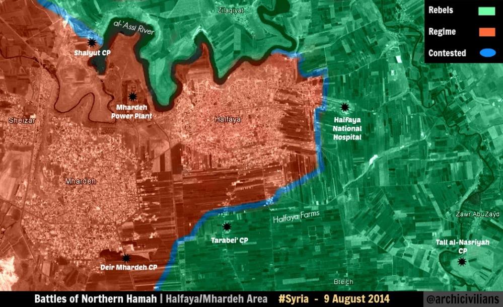
That's the same archcivilians map which incorrectly showed Halfaya as gov't held, and not contested, which we now know it was, yea? Boredwhytekid (talk) 19:59, 26 August 2014 (UTC)
The bias is terrible man. We have 2 pro-op sources - SOHR and archcivilians - with conflicting reports, and immediately the decision goes to archcivilians, even though it's just another random map, no different then ours, no special access or sources that we don't have, but we use it as a source. I say "we" - I mean pro-gov't editors, who jump on these random maps - archcivilians, desyracuse, peterwhatshisface - and use them for pro-gov't gains. Why are we using random individual's maps? Does anyone have an answer to that? Why are we assuming their maps are more accurate then ours? Boredwhytekid (talk) 20:04, 26 August 2014 (UTC)
- Here reliable source Al Monitor on 24 August also reported that clashes around city Mhardeh which under control by Syrian troops. But I see that you and this is small. Hanibal911 (talk) 20:10, 26 August 2014 (UTC)
Actually no. Halfaya was not contested at the time Bored. Halfaya became contested a week after that map was made. P.S. As the map shows, the power plant, that was mentioned earlier, is OUTSIDE the city, not inside it. EkoGraf (talk) 21:53, 26 August 2014 (UTC)
What source are you basing that claim on? If you have one, why didn't you bring it forward to make Halfaya contested? Boredwhytekid (talk) 12:25, 27 August 2014 (UTC)
Talbisa
clashes between regime forces against Jabhat al-Nusra and Islamic battalions in the western side of Talbisa.SOHR Hanibal911 (talk) 16:36, 26 August 2014 (UTC)
Hamamiyat
The village Hamamiyat now under control by army this confirm pro government source here and pro opposition source here also showed that area neae city Kafr Zita which located village of Hamamiyat under army control. Hanibal911 (talk) 18:35, 26 August 2014 (UTC)
deSyracuse and pietervanostaeyen
Again, why are we using these as sources? These are nothing but two random individuals' maps. They are not authoritative at all. They do not have access to information that we do not. Only pro-gov't editors press to keep these jokes of sources to use them for pro-gov't editing. This is a sham and a discredit to this map. Boredwhytekid (talk) 19:01, 26 August 2014 (UTC)
- DeSyracuse it is pro opposition source and here is proof map from the source DeSyracuse
- is almost identical to another pro opposition map you can compare them yourself. So that if you looking at both of these cards is becoming understood that the source deSyracuse make most of edits on based on pro opposition sources. Hanibal911 (talk) 19:16, 26 August 2014 (UTC)
Do they have like, secret clearance or something? We have tons of editors here scouring the internet for sources - why do we use these random people's maps as though they have access to info that we do not? Boredwhytekid (talk) 19:37, 26 August 2014 (UTC)
Another reason I can't belive on this map is eastern Hama.This is the highway to Iritrhya [21] which is the supply route for Alepo so now all of a sudden parts of the highway are controlled by ISIS.Sorry but that would have made it to the news or at least SOHR.I rely don't think ISIS controls these villages or at least the ones near the highway which are 5-7km from the highway.I would hardly think the Army can advance like it is advancing in the moment without supplies so that section of the map is wrong as ISIS conttroled villages are way to close to the highway and with ATGM's that they have they can close the higway at will which is not the case.Daki122 (talk) 10:39, 27 August 2014 (UTC)
So ANY map you find floating around online, regardless of its authority or accuracy, can be used for pro-regime edits if the UNKNOWN, UNVERIFIED, UNQUALIFIED creator of the map claims to be pro-opp? This is like something out of the god damn Twilight Zone.
- That's correct. Go make a map, show some miniscule gov't advance that is not true and we'll label you pro-gov't and use you as a source for pro-opp gains. Boredwhytekid (talk) 12:16, 27 August 2014 (UTC)
Actually we never used a pro-gov map for government advances until now but we have constantly used maps that are pro-opp for opposition advances which I frankly think is unfair given that the sources are fans of the opposition and will make any map to suit there imagination even tough that is not true on the ground.Daki122 (talk) 17:47, 27 August 2014 (UTC)
Oh please, show me where we are using amateur maps claiming to be pro-regime and using these maps to record rebel advances? The only people doing that are the ones using this Syracuse guy to show regime advances despite having no idea who this guy is, where his true allegiances lie, or anything else for that matter. SOHR is being used to show rebel advances because it has been proven to be more or less reliable most of the time, while regime news sources have not shown a single rebel advance in the entire 3 years of war. That's actually why this map is such an inaccurate mess - relying on state-controlled authoritarian media to fairly report the news. EVEN IN THE RARE CASES WHERE SANA ADMITS A LOSS - SUCH AS AT TABQA AIRBASE - THE EDITORS HERE STILL INSIST ON BEING BIASED AND BESIEGING THE AIRBASE DESPITE NO EVIDENCE OF SUCH A THING.
Stop vandalising Tabqa around
The airbase is NOT under regime siege. Is under full IS control, yes, some clashes maybe around according to SOHR, put SOHR reports clashes around many places, such as Deir Ez-Zor Airport, put you don't put it under siege, so why to put Tabqa? It's not under any siege, regime lost all of Raqqa for now. — Preceding unsigned comment added by 179.179.152.147 (talk) 02:59, 27 August 2014 (UTC)
I will be removed the red circle if nobody post sources here in next hours --Pototo1 (talk) 05:48, 27 August 2014 (UTC)
- SOHR said that clashes around al-Tabaqa military airport.source Hanibal911 (talk) 06:48, 27 August 2014 (UTC)
--Removed: flamebaiting
- Can't say I disagree.. Boredwhytekid (talk) 12:18, 27 August 2014 (UTC)
- So essentially, ban everyone who does not agree with what you say the first time you say it. Yes, that will get us closer to an unbiased map. — Preceding unsigned comment added by 2602:30A:C01B:89F0:4C1F:A767:8E14:8CED (talk) 20:12, 27 August 2014 (UTC)
http://www.telegraph.co.uk/news/wor...Syrian-soldiers-in-latest-brutal-killing.html
Fleeing soldiers from Tabqa airbase are marched in the desert and executed en masse...
Map shows the regime besieging Tabqa...
Fleeing soldiers...mass execution...besieging Tabqa...
Something is wrong with this picture... — Preceding unsigned comment added by 80.184.67.215 (talk) 20:46, 28 August 2014 (UTC)
Suwayda province
In this map, Suwayda province is all red. This is not true. There have been clashes in the past few weeks, resulting in the loss of control of the SAA and NDF over several sunni Arab towns inside Suwayda province. Al-Monitor article: http://www.al-monitor.com/pulse/originals/2014/08/clashes-bedouin-druze-as-suwayda-syria.html Source of fighting near Al-Lajat and refugees: http://www.middleeasteye.net/news/hundreds-families-lajat-syria-home-dusty-cave-2032435396 Source for Dama with rebel presence nearby: http://www.dailystar.com.lb/News/Middle-East/2014/Aug-18/267518-druze-bedouin-violence-erupts-near-syrias-lajat-region.ashx#axzz3Bg3pKSV7 Zibin source: https://www.facebook.com/syriahroe/posts/551874828254193
I suggest to green:
- Al-Lajat
- Eib (tiny village near Al-Lajat)
Red with green circle:
- Dama/Deir Dama
- Zibin
Also, this would make Busra al-Harir in eastern Daraa to green. I can find no source saying it's contested, maybe some barrel bombs. It was also not discussed on this page. Also, in eastern Daraa, I would like to add the towns of Al-Tayyibah and Mitayiah as rebel held. Those two towns are near the Jordianian border, which is under Jabhat al-Nusra control. This is the route weapons are smuggled into towns like Hirak and Bosra. — Preceding unsigned comment added by 84.24.43.183 (talk) 09:33, 27 August 2014 (UTC)
- Firstly source Al Monitor said that Syrian army, backed by NDF, has managed to regain control over Deir Dama and managed to counter an attack against the Dama village in the countryside of Suwayda but beduin fighters still shelled villages Deir Dama and Dama. Thid also confirmed pro opposition map
- And Al Lagat it is not town or village it is only area in Dara province.herehere
- And SOHR said that the Islamic and rebel battalions targeted the regime - held areas in the city of Bosra al Harir.SOHR Hanibal911 (talk) 10:28, 27 August 2014 (UTC)
- I add on map the village Eib. Hanibal911 (talk) 10:35, 27 August 2014 (UTC)
- And SOHR said that the Islamic and rebel battalions targeted the regime - held areas in the city of Bosra al Harir.SOHR Hanibal911 (talk) 10:28, 27 August 2014 (UTC)
- And Al Lagat it is not town or village it is only area in Dara province.herehere
I understand. However, the map and SOHR clearly shows town in rebel hands north of Busra al-Harir. I advocate adding Mseihek and Jaddal to this map. This way it seems like Eib is flooting somewhere in the middle of nowhere without clear lines towards rebel held terretory. What about Zibdin and the town inside Daraa province near the Jordanian border west of Nasib? — Preceding unsigned comment added by 84.24.43.183 (talk) 11:34, 27 August 2014 (UTC)
- Reports about clashes near the village Zibdin was almost two months ago but more no was any messages about the clashes in this area. And we cant use pro opposition map to add rebel - held villages or towns. So that SOHR not said that Mseihek and Jaddal now under rebel control. Hanibal911 (talk) 11:45, 27 August 2014 (UTC)
Daraa accuracy
Is there any proof whatsoever that Tasil is contested by the regime? What about Jasim? And I'm not talking about airstrikes or shelling which don't warrant a "contested" icon, I am talking about proof that there is regime elements in these towns fighting against the rebels in these towns which have been held by the rebels for longer than a year. — Preceding unsigned comment added by 80.184.67.215 (talk) 11:28, 27 August 2014 (UTC)
- There have not been reports of fighting in these towns for weeks, months even. Unfortunately though, that logic only works if you are suggesting a pro-gov't edit, such as the Suweida conversation taking place directly above this section. Boredwhytekid (talk) 12:22, 27 August 2014 (UTC)
I agree. Jasim and Tasil should both be green. Rebels are advancing in Daraa, not fighting for their lives. This map is not showing what is really happening in Daraa/Quinaitra/Suwayda:
- Jasim to green, maybe red circle/half circle pressence nearby on two hills
- Tasil to green
- Add Beduin towns in Suwayda as rebel held — Preceding unsigned comment added by 84.24.43.183 (talk) 12:48, 27 August 2014 (UTC)
- You must indicate the sources who can confirm your statements about Al Suwayda province. Hanibal911 (talk) 13:13, 27 August 2014 (UTC)
- And also on 14 August pro oppositio source showed that Al Suwayda province under control by army. And later on 18 August another pro opposition source show that rebels located on small part in province Al Suwayda near the Dara province but not indicated that rebels now control any villages. So dont need make unfounded statements. Hanibal911 (talk) 13:31, 27 August 2014 (UTC)
SOHR had reports that clashes are taking place in both Tasil and Jasim towns until you have any better source they stay contested.Daki122 (talk) 17:51, 27 August 2014 (UTC)
SOHR had reports? When? Tasil being contested is pathetic. Rebels control all territory north, south, west and east of it, no clashes have been reported for MONTHS, while it is still contested? If it was contested, at least we would see some ocasional gunfire in reports, but NOTHING is reported. What's the big deal in changing it to green anyway? You guys are putting the Tabqa Airbase to besieged for god know's what reason and you can put OBVIOUS rebel held town to green. Yes, you editors are pro-regime, everyone knows it, but this is borderline pathetic. — Preceding unsigned comment added by 177.204.47.29 (talk) 23:45, 27 August 2014 (UTC)
Quneitra
Rebels captured Quneitra crossing [22]. [23] --איש המרק (talk) 12:30, 27 August 2014 (UTC)
REUTERS reports that the urban center/ town of Quneitra is under state control. However the border crossing of Quneitra that is almost 20 kilometers west of Quneitra has been captured by AN and its allied western-supplied "moderate" rebels. http://in.reuters.com/article/2014/08/28/syria-crisis-border-fighting-idINKBN0GS04H20140828 — Preceding unsigned comment added by 169.231.3.204 (talk) 03:43, 28 August 2014 (UTC)
Quneitra crossing fell to the rebels
http://news.yahoo.com/rebels-syria-crossing-israel-occupied-golan-ngo-110506731.html http://www.dailystar.com.lb/News/Lebanon-News/2014/Aug-27/268671-syrian-rebels-seize-control-of-qunaitra-crossing-into-golan-heights-activists.ashx#axzz3BaxIp9ci Boredwhytekid (talk) 12:31, 27 August 2014 (UTC)
The rebels captured the crossing, but the town of Quneitra itself, 20 kilometers east, is still held by the SAA [24]. A red dot for the town needs to be added. EkoGraf (talk) 07:33, 28 August 2014 (UTC)
Bteich checkpoint
Bteich checkpoint should red. According to sohr :The Islamic battalions and al Nusra Front targeted regime’s gatherings in Btesh checkpoint by the heavy gun machines https://www.facebook.com/syriahroe/posts/575525282555814212.252.198.124 (talk) 17:31, 28 August 2014 (UTC)
why Flitah change to red to contested ?
sources or it go to red again in next hours --Pototo1 (talk) 19:05, 28 August 2014 (UTC)
via https://www.facebook.com/syriahroe/posts/575180572590285, Falita is contested and stop reverting edits with reliable sources.Alhanuty (talk) 02:50, 29 August 2014 (UTC)
- But SOHR partly biased in the rebels side and no one from another reliable sources not said that clashes in this city. And it can be was only hit and run atack because even SOHR more not said about clashes inside city of Flita. Also on 23 August SOHR reported that clashes in the city Talbisa but we not change him to contested because SOHR more not said about clashes in this city. I also didnt find reports about clashes in the city Flita in the reports on the site SOHR Hanibal911 (talk) 05:31, 29 August 2014 (UTC)
Then using the same logic change Tasil to green ya manyak. — Preceding unsigned comment added by 80.184.67.215 (talk) 08:10, 29 August 2014 (UTC)
Question on East of Damascus
Does any evidence exist showing that the khan abu shaman base and battalion 559 remain in rebel hands? These are both shown as green but the rebels have no green towns in these areas. These are directly east of damascus. Any information on this area? — Preceding unsigned comment added by 169.231.67.155 (talk) 19:35, 28 August 2014 (UTC)
They are rebel held. If regime had retaking them, at least pro-regime source would had talked about it. — Preceding unsigned comment added by 177.204.47.29 (talk) 21:08, 28 August 2014 (UTC)
The rebels no have a a full control from a single town in these areas --Pototo1 (talk) 21:43, 28 August 2014 (UTC)
They don't, but they control the bases. Stop crying that your precious dictatorship forces have lost a couple of bases. — Preceding unsigned comment added by 177.204.47.29 (talk) 22:34, 28 August 2014 (UTC)
That dictatorship gave free religion, healthcare and security to Syria you fucking braindead. Cause shaira law with mass beheadings and crucifying shias is not dictatorship right? shitface