
Sotira, Famagusta: Difference between revisions
Content deleted Content added
municipality website |
this is all copied from the municipality's website; football club has its own page |
||
| Line 1: | Line 1: | ||
{{Other uses|Sotira (disambiguation){{!}}Sotira}} |
{{Other uses|Sotira (disambiguation){{!}}Sotira}} |
||
{{Original research|date=November 2014}} |
|||
{{Infobox settlement |
{{Infobox settlement |
||
| name = Sotira |
| name = Sotira |
||
| Line 104: | Line 103: | ||
'''Sotira''' ({{lang-el|Σωτήρα}}) is a town in the [[Famagusta District]] of [[Cyprus]], west of [[Paralimni]]. In 2011, it had a population of 5,474. |
'''Sotira''' ({{lang-el|Σωτήρα}}) is a town in the [[Famagusta District]] of [[Cyprus]], west of [[Paralimni]]. In 2011, it had a population of 5,474. |
||
== Geography == |
|||
=== Geomorphology === |
|||
Sotira is built on an average altitude of 75 meters above the sea. Τhe landscape is as a plain and has a little inclination to the sea. |
|||
=== Flora and fauna === |
|||
A piece of Paralimni lake belongs to Sotira. That means that there is a great flora and fauna which has to be protected by international organisations. A type of snake called "nerofido" ({{lang-el|νερόφιδο}}) exists in Paralimni lake and it's protected by the Cypriot government. |
|||
| ⚫ | |||
=== Name origin === |
|||
The name of Sotira means "Savior" in Greek. Some of the legends about the creation of the village says that an ancient settlement used to live near the coastal area of Ayia Thekla. After a pirate attack, the group was forced to move to a more secure zone, so they did. They moved to the place where Sotira exists till today, and they gave that name to the village because of their salvation from the pirates. Another legend says that the name of Sotira came from the Church of Transfiguration ({{lang-el|Ιερός Ναός Μεταμορφώσεως του Σωτήρος}}) which was built in the 12th century by the Byzantines. |
|||
== Demographics == |
|||
=== Occupations === |
|||
The main occupations of the people who live in Sotira is agriculture and livestock. In addition, Sotira is known for its plant called "kolokasi" ({{lang-el|κολοκάσι}}), which in English is known as "Taro". Since 2009, there is a festival held every year dedicated to "kolokasi", usually on October. |
|||
The last years there is observed a small industrial development which is expected to have a further development the next years, after the conversion of Sotira into a Municipality. |
|||
=== Population === |
|||
Sotira's inhabitants over the last century are configured as follows: |
|||
{| class="wikitable" |
|||
|- |
|||
! Year !! Number of inhabitants |
|||
|- |
|||
| 1946 || 1,037 |
|||
|- |
|||
| 1960 || 1,515 |
|||
|- |
|||
| 1982 || 3,015 |
|||
|- |
|||
| 1992 || 3,553 |
|||
|- |
|||
| 2001 || 4,259 |
|||
|- |
|||
| 2011 || 5,474 |
|||
|} |
|||
== Local government == |
|||
Government of Cyprus decided to convert Sotira into a Municipality after a request from the Community Council of the village. Thus, residents of Sotira voted on July 3, 2011 and a percentage of 90,35% said yes. The conversion of Sotira into a Municipality was on 1 January 2012. The current mayor of the town is Georgios Ttakkas. |
|||
== Football Club == |
|||
The town's football club is Onisilos Sotiras FC named after the revolutionary Onisilos,. The club was founded in 1978. Onisilos FC is a regular team at the second division for many years. Their greatest achievement so far is participating in the top division of the island in 2003-2004 season. The town is proud of its club as many of its footballers are actually locals. Many star players of Cyprus started from the club. The most famous [[Dimitris Christofi]] was sold by his former club [[AC Omonoia]] to [[FC Sion]] for over 1 million euros. He is the main striker of the Cypriot National Team. |
|||
== Coastal area == |
|||
The coastal area of Ayia Thekla is just 5 kilometers west of Ayia Napa, the most famous summer resort of Cyprus and across Europe. Also, it is located 8 kilometers south of Sotira and 50 kilometers east of the airport of Larnaca. |
|||
Ayia Thekla has evolved due to the property boom which has occurred since Cyprus joined the EU in 2004. The last 6 years Ayia Thekla had a development on properties and villas and it also had a blue flag for Ayia Thekla beach, after a movement of Sotira's community council. |
|||
== Gallery == |
== Gallery == |
||
| Line 157: | Line 108: | ||
File:Aerial view of Ayia Thekla beach.jpg|Aerial view of the beach and the chappel |
File:Aerial view of Ayia Thekla beach.jpg|Aerial view of the beach and the chappel |
||
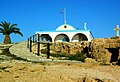
File:The chappel from above.jpg|St Thekla chappel |
File:The chappel from above.jpg|St Thekla chappel |
||
File:Blue Flag Logo.svg|The blue flag logo |
|||
File:The chappel of Ayia Thekla.jpg|St Thekla chappel |
File:The chappel of Ayia Thekla.jpg|St Thekla chappel |
||
File:Sotira's municipal amphitheater.jpg|Sotira's municipal amphitheater |
File:Sotira's municipal amphitheater.jpg|Sotira's municipal amphitheater |
||
File:AyiaTheklabeach.jpg|The beach of Ayia Thekla |
File:AyiaTheklabeach.jpg|The beach of Ayia Thekla |
||
</gallery> |
</gallery> |
||
| ⚫ | |||
* [[Onisilos Sotira]], the town's football club |
|||
== References == |
== References == |
||
Revision as of 12:28, 16 November 2014
Sotira | |
|---|---|
| Country | |
| District | Famagusta District |
| Population (2011)[1] | |
| • Total | 5,474 |
| Website | www |
Sotira (Greek: Σωτήρα) is a town in the Famagusta District of Cyprus, west of Paralimni. In 2011, it had a population of 5,474.
Gallery
-
 Aerial view of the beach and the chappel
 -
 St Thekla chappel
 -
 St Thekla chappel
 -
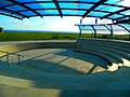 Sotira's municipal amphitheater
 -
 The beach of Ayia Thekla


See also
- Onisilos Sotira, the town's football club
References
- ^ "Population - Place of Residence, 2011". Statistical Service of Cyprus (CYSTAT). 17 April 2014.
