
Talk:Control of cities during the Syrian civil war: Difference between revisions
m Archiving 3 discussion(s) to Talk:Cities and towns during the Syrian Civil War/Archive 39) (bot |
|||
| Line 372: | Line 372: | ||
Well then change Al Ghafer, because we already had a section on this talk page where you suggested that Al Ghafer should be changed, and nobody complained. [[User:DuckZz|DuckZz]] ([[User talk:DuckZz|talk]]) 15:49, 16 January 2015 (UTC) |
Well then change Al Ghafer, because we already had a section on this talk page where you suggested that Al Ghafer should be changed, and nobody complained. [[User:DuckZz|DuckZz]] ([[User talk:DuckZz|talk]]) 15:49, 16 January 2015 (UTC) |
||
: {{Done}} [[User:Hanibal911|Hanibal911]] ([[User talk:Hanibal911|talk]]) 19:56, 16 January 2015 (UTC) |
: {{Done}} [[User:Hanibal911|Hanibal911]] ([[User talk:Hanibal911|talk]]) 19:56, 16 January 2015 (UTC) |
||
Just keep an eye on it as pro gov sources report attacks on Kafr Takharim and Almanaz north of Al Ghafer .[[User:Pyphon|Pyphon]] ([[User talk:Pyphon|talk]]) 10:10, 17 January 2015 (UTC)pyphon |
|||
== Talbiseh (again) == |
== Talbiseh (again) == |
||
Revision as of 10:10, 17 January 2015
| This is the talk page for discussing improvements to the Control of cities during the Syrian civil war article. This is not a forum for general discussion of the article's subject. |
Article policies
|
| Find sources: Google (books · news · scholar · free images · WP refs) · FENS · JSTOR · TWL |
| Archives: Index, 1, 2, 3, 4, 5, 6, 7, 8, 9, 10, 11, 12, 13, 14, 15, 16, 17, 18, 19, 20, 21, 22, 23, 24, 25, 26, 27, 28, 29, 30, 31, 32, 33, 34, 35, 36, 37, 38, 39, 40, 41, 42, 43, 44, 45, 46, 47, 48, 49, 50, 51, 52, 53, 54, 55, 56, 57, 58, 59, 60, 61, 62, 63, 64, 65Auto-archiving period: 7 days |
| This page is not a forum for general discussion about Control of cities during the Syrian civil war. Any such comments may be removed or refactored. Please limit discussion to improvement of this article. You may wish to ask factual questions about Control of cities during the Syrian civil war at the Reference desk. |
| This article is of interest to the following WikiProjects: | |||||||||||||||||||||||||||||||||||||||||||||
| |||||||||||||||||||||||||||||||||||||||||||||


.svg)
| To help centralise discussions and keep related topics together, Template talk:Syrian Civil War detailed map redirects here. |
Template:Syrian Civil War sanctions
|
Index 1, 2, 3, 4, 5, 6, 7, 8, 9, 10 |
|
This page has archives. Sections older than 7 days may be automatically archived by Lowercase sigmabot III when more than 4 sections are present. |
Syrian Army captured more Towns in North Hama
Syria TV report with subtittles. https://www.youtube.com/watch?v=5wx-VBCu4X0 — Preceding unsigned comment added by 190.203.137.34 (talk • contribs) 21:41, 3 October 2014
Al Qaeda is in All Green Towns
All Qaeda is in All Green Towns not only in Idlib Towns
The so called Islamic Front Was created by Al Qaeda member Abu Khaled al-Suri he was killed by the ISIS http://www.cbc.ca/news/world/syria-suicide-bombers-kill-al-qaeda-rebel-leader-in-aleppo-1.2548340
Even if you don't consider the islamic front as part of AQ, the nusra which is cleARLY AQ is in the vast majority of green areas.
SHouldn't a grey dot be put then within most of the greens (if it can be documented)? That could be used to show they are working together.
If hezbollah is the main garrison in any government town, I would understand putting a yellow dot within the red. Although I think they are primarily focused in a few areas, from what I've read.
— Preceding unsigned comment added by 72.252.161.166 (talk • contribs) 23:39, 13 November 2014
Menagh & northern Aleppo
A frightening situation , this article explains that FSA has withdrawn from Menagh and Nursa has taken control of this. It says fighting between Nusra and FSA has moved to Aleppo’s countryside. So it is not just in Idlib countryside now. http://www.al-monitor.com/pulse/originals/2014/11/jabhat-al-nusra-idlib-islamic-emirate.html — Preceding unsigned comment added by 72.252.161.166 (talk • contribs) 20:54, 13 November 2014
- Dozens of fighters from Jabhat al-Nusra pledged allegiance to the IS northeast of Aleppo.SOHR — Preceding unsigned comment added by Hanibal911 (talk • contribs) 21:25, 14 November 2014
Jaz'ah
According to SOHR's report http://syriahr.com/en/2014/11/7-militants-died-in-clashes-with-ypg-in-ras-al-ayn/ 2 villages(Mestriha and Felastin) south of Jaz'ah should be contested. — Preceding unsigned comment added by Saeed alaee (talk • contribs) 06:39, 18 November 2014
There we Go Again ...
And again we have pro-SAA editors change the Daraa and Quneitra map towards their own views without sources. I want the following questions answered with neutral sources:
1. Why was Dilli changed back to red and why is the 60th Engeneering Regiment nearby deleted as a green army base dot? 2. Why is the green circle around Mahajjah deleted, whilst SANA itself says there were bombings there, so rebels nearby? 3. Why is the city of Bosra changed from contested to red without a neutral source given? 4. There is a grey JaN ring in Nawa, whilst there is no infighting in southern Syria. So why the grey ring?! 5. Why is Tell Antar contested? No sources given
And before people start bombarding this post with PetroLucum or Al-Masdar stuff, I mean neutral sources. Al-Minotor wrote an article which states Sheikh Maskin and Brigade 82 should be green, as well as many towns north of it. We ignored it based on Al-Masdar reports (could as well listen to SANA). So, if that's the case, I will use Twitter sources from opposition activistst to change towns to green, since that is what pro-SAA people here do to contested and rebel towns in the south. — Preceding unsigned comment added by 84.24.43.183 (talk • contribs) 08:52, 19 November 2014
1- Dilli needs to be contested. The rebels took it, the regime counter-attacked and now clashes are happening inside the village. You used a totally pro-regime source to change it back to red. Also, SOHR reported 60th Batallion to be on rebel hands, so put it back(it's a small base, so maybe use a checkpoint icon).
2- Add the Daara Central Prison back, as it was AGAIN excluded. This is getting really boring.
— Preceding unsigned comment added by 179.183.246.229 (talk • contribs) 11:15, 19 November 2014
Nubl and Zahraa
SOHR reports has talked aout clashes inside Nubl and Zahraa,but i believe more confirmation and reports must come inorder to change them contested any other opinions
https://www.facebook.com/syriahroe/posts/638641326244209.Alhanuty (talk) 22:38, 7 January 2015 (UTC)
SOHR has a very bad English translation. The clashes are most likely in the towns outskirts. Nubl and Zahraa are fortified enough to hold any rebel offensive for quite sometime. — Preceding unsigned comment added by 200.219.152.90 (talk) 23:24, 7 January 2015 (UTC)
- In original article SOHR reported that clashes in the vicinity the towns of Nubl and Zahraa between Islamic battalions and combat brigades and Al-Nusra fighters (al-Qaeda in the Levant) of the party, and the National Defence Forces and local gunmen.SOHR Hanibal911 (talk) 08:24, 8 January 2015 (UTC)
- So that in the future will be better before edit find the original report. Since the reports which we read in the SOHR page in Facebook may differ from the original reports! Hanibal911 (talk) 08:31, 8 January 2015 (UTC)
I want to make an industrial complex icon right here. SOHR and other channels are always mentioning this area when talking about Zahra and Nubl clashes.
- Also there's a Silk factory in this complex right here, so it would be plausible to make this icon which includes this factory and area around it.
- According to rebel channels, regime forces control this area and rebels are shelling them with mortars. Here's a video, on the left you can see the white buildings. DuckZz (talk) 17:12, 8 January 2015 (UTC)
We should keep a eye on Nubl and Zahra. Nusra terrorists and IF launched a new offensive. — Preceding unsigned comment added by 177.97.166.52 (talk) 18:59, 8 January 2015 (UTC)
Hanibal911 Last night every attack was repeled by the SAA & NDF forces, dozens of dead JAN members, but they started another offensive this evening and they advanced towards the mid square of Al-Nubl. New map posted 2 hours ago. DuckZz (talk) 21:39, 8 January 2015 (UTC)
- DuckZzPro government source here and pro opposition source here showed that clashes on the outskirts of the town Nubl. Syrian troops backed by NDF and Hezbollah already smashed two of three attacks on towns of Nubl and Zahraa and inflicted heavy casualties of Al Nusra. Last attack ongoing takes place to southeast of Al-Zahraa. Battle raging about 300 meters from the towns outskirts.herehere Also the reliable source reported that Al Nusra didn't managed to break into the East side of Al Zahraa despite claim on social media.Elijah J. Magnier Because in Nubl and Al Zahraa have more or less 6,000 fighters.Elijah J. Magnier Their last attack was repulsed.Elijah J. Magnier Hanibal911 (talk) 22:06, 8 January 2015 (UTC)
- Also a reliable source reported that activists from the town Al Zahra denied report about Al Nusra advance in town of Nubl. Elijah J. Magnier Hanibal911 (talk) 22:19, 8 January 2015 (UTC)
I am really confused. Now Al Jazeera is saying that rebels control 50% of Al Nubl lol. Hard to belive really but lets wait a couple of days. We know that rebels have a strong media, they will probably provide some photos/videos from inside the city if confirmed. DuckZz (talk) 22:33, 8 January 2015 (UTC)
- I have not found messages from Al Jazeera in which says that rebels control 50% of town Nubl. About this only said biased the antigovernment source Archicivilians here but anyway the reliable source reported that all Al Nusra attacks was repelled. Hanibal911 (talk) 22:42, 8 January 2015 (UTC)
Bur SOHR reported that Nusra entered the towns for the first time,what do you suggest to be done,then Hannibal.Alhanuty (talk) 23:47, 8 January 2015 (UTC)
- Since so many other sources have said that the attack failed, nothing will be done until more time has passed. XJ-0461 v2 (talk) 01:30, 9 January 2015 (UTC)
- Alhanuty But another a reliable source reported that attack was repelled and Al Nusra not entered to the town.Elijah J. MagnierElijah J. Magnier And SOHR reported that al- Nusra and Islamic battalions could take control over streets in the south of the town al- Zahraa and buildings in the east town of Nubl but NDF and local gunmen from the two towns could re-take these streets and building.SOHRSOHR Also pro opposition source reported that rebels still far away from Zahraa.here Hanibal911 (talk) 07:35, 9 January 2015 (UTC)
- According to the SOHR the insurgents were briefly able to control streets in the southern part of Zahra and buildings in the nearby village of Nubl, north of city Aleppo. But the militants, who used tanks, were pushed back from both areas by the National Defense Force, a grouping of loyalist militias under the umbrella of the army.The Daily Star Hanibal911 (talk) 09:14, 9 January 2015 (UTC)
- Also pro opposition source said that Al-Nusra insurgents seized several streets in the southern part of the village of Zahra and buildings in the nearby village of Nubl, north of the city of Aleppo. But activist Hazim Yunis in Aleppo reported that pro-Assad forces of the National Defense were able to push the al-Nusra fighters back on evening.ARA News Hanibal911 (talk) 09:13, 10 January 2015 (UTC)
- According to the SOHR the insurgents were briefly able to control streets in the southern part of Zahra and buildings in the nearby village of Nubl, north of city Aleppo. But the militants, who used tanks, were pushed back from both areas by the National Defense Force, a grouping of loyalist militias under the umbrella of the army.The Daily Star Hanibal911 (talk) 09:14, 9 January 2015 (UTC)
- Alhanuty But another a reliable source reported that attack was repelled and Al Nusra not entered to the town.Elijah J. MagnierElijah J. Magnier And SOHR reported that al- Nusra and Islamic battalions could take control over streets in the south of the town al- Zahraa and buildings in the east town of Nubl but NDF and local gunmen from the two towns could re-take these streets and building.SOHRSOHR Also pro opposition source reported that rebels still far away from Zahraa.here Hanibal911 (talk) 07:35, 9 January 2015 (UTC)
- Syrian pro-regime militia have repelled an incursion by al-Qaida on two Shiite Muslim villages in the north of the country.
The villages of Nubol and Zahraa in Aleppo province had been under siege by Al-Nusra Front, al-Qaida's Syria branch, and other Islamist rebels for a year and a half. SOHR said that Al-Nusra fighters entered the villages on seven tanks. It was a major, simultaneous attack. The National Defence Force, a pro-government militia, repelled the attack with support Syrian air force and jihadists withdrew.NaharnetDaily MailArab TodayAD-HOC NewsReuters Hanibal911 (talk) 09:26, 10 January 2015 (UTC)
Talbiseh
Pro opposition source said that clashes break out between Syrian Army and opposition fighters in city Talbiseh in Homs countryside.DocumentSyDocumentSy So that guys maybe some one of editors to have other data about situation in this city. Hanibal911 (talk) 13:16, 9 January 2015 (UTC) Fighting in this town has been reported several times in the recent past. I guess from SOHR. See also [1] (pro-opp). It is maybe time to turn it into contested.Paolowalter (talk) 15:38, 9 January 2015 (UTC)
- But also earlier 23 December pro opposition source reported that clashes took place between FSA and regime troops in the outskirts of the city of Talbiseh.Revolutionary Forces of Syrian Media Office Hanibal911 (talk) 16:56, 9 January 2015 (UTC)
- Talbiseh is a rebel stronghold. It is not contested. Just south of the city there is the Malouk army complex from which army troops attack the southern border of the city. This has been going on for months, but the rebels are holding up well... so the city is not contested & the clashes can still be reported routinely for months in the future along the same pattern. No evidence that army troops can do anything other than hit & run attacks. The red semi-circle is enough for now. Tradediatalk 06:34, 10 January 2015 (UTC)
- How do you know that?Paolowalter
- See [2].
Paolowalter (talk) 21:54, 10 January 2015 (UTC) If any, it confirms fighting inside the city.Paolowalter (talk) 18:19, 11 January 2015 (UTC) http://www.almasdarnews.com/article/homs-syrian-army-makes-swift-gains-north/ — Preceding unsigned comment added by 95.155.17.25 (talk) 16:25, 16 January 2015 (UTC)
Amateur maps.
In 3 days time with nothing but an amateur map as a source, 16 red villages, 4 red villages, 6 red villages, 9 red villages, 5 red bases, 1 red base, 6 red bases, 2 red bases, 4 red bases, Khirbat al Atrah to red (which is a joke - to show any SAA-held village in NW Aleppo as NOT besieged), Hawsh Haju to red. How many of those actually add anything of consequence to the map? Are any corroborated by any other source? It's just a piling on of inconsequential red clutter, in most cases*.. Boredwhytekid (talk) 19:34, 9 January 2015 (UTC)
well it does provide a more accurate view of what sides hold villages and a large part of the population centers. If small IS held dessert villages are marked on the map, why cannot larger villages in Latakia and other areas also be included? — Preceding unsigned comment added by 169.231.156.148 (talk) 19:55, 9 January 2015 (UTC)
- Because before the tiny IS villages our map didn't show that IS indeed held the territory, though it was common knowledge that it was. Adding villages in Latakia doesn't do anything but add more of the color red, since we already know and show Latakia as SAA held (NE section excluded).
- Boredwhytekid We use pro opposition maps to show army success. So that dont need each time start one and the same discussion. Also on this map clearly indicated names of all military installations that I added. After all, we are also use the pro government maps to show the success of the rebels. Hanibal911 (talk) 21:27, 9 January 2015 (UTC)
- I cant understand why when we use pro-government maps to show the success of the rebels, no one is objection. But as soon as we use pro-opposition maps to show success army then some one of editors immediately begin objections saying that need another confirmations from other sources. Hanibal911 (talk) 21:53, 9 January 2015 (UTC)
- And this edit which I was made was need to show more detaled situation in this areas. We earlier also for improve on map add without specifying sources the several villages and military objects under control by rebels in Idlib and Aleppo province. And we all agreed with this and there were no objections. But when for improve on map and on the basis of data from pro-opposition map I added some villages and military facilities that are under the control of the army as it caused a protest. So I not violated the rule of edit because as we all agreed to use pro-government maps to show the success of the rebels and pro-opposition maps to show the success of army. Hanibal911 (talk) 22:33, 9 January 2015 (UTC)
- I cant understand why when we use pro-government maps to show the success of the rebels, no one is objection. But as soon as we use pro-opposition maps to show success army then some one of editors immediately begin objections saying that need another confirmations from other sources. Hanibal911 (talk) 21:53, 9 January 2015 (UTC)
- Boredwhytekid We use pro opposition maps to show army success. So that dont need each time start one and the same discussion. Also on this map clearly indicated names of all military installations that I added. After all, we are also use the pro government maps to show the success of the rebels. Hanibal911 (talk) 21:27, 9 January 2015 (UTC)
- Because before the tiny IS villages our map didn't show that IS indeed held the territory, though it was common knowledge that it was. Adding villages in Latakia doesn't do anything but add more of the color red, since we already know and show Latakia as SAA held (NE section excluded).
- I'd have to say as a neutral every time I suggest a change, regime or rebel related, I get opposed. I mean it took me days to convince some editors to change Khazzanat to green, Bir Qasab to black and southern Aleppo villages to red. If an editor provides sufficient proof using a source that we have always used to show the opposite side's gains, then so be it. SOHR for regime (and most rebel) advances, Al Masdar for rebel (and some regime) advances, DeSyraCuse and ArchiCivilians for regime advances and Peto Lucem for rebel advances. There is no perfectly 100% accurate neutral source concerning both sides (except maybe AL-Monitor and Elijah). Wikipedia is for facts not opinions/fantasies. Hanibal911 with my help added rebel and regime bases yet got opposed by supporters of both sides. He did a fair job. We added 4 rebel bases in Southern Idlib/Aleppo and added 4 regime bases in Rif Dimashq. We also added some villages in E-Idlib after Boredwhytekid correctly suggested that we do. Yet every time someone is not satisfied. The sites we added exist so where is the problem? Of course "spamming" an area with towns/farms is not helpful but still military sites get a priority because they are less numerous. Sorry for the long post but all I wanted to say to some editors here was stay factual and don't be biased. It doesn't help the map. Adding something that exists isn't lying but also spamming doesn't help. ChrissCh94 (talk) 23:30, 9 January 2015 (UTC)
Personally i have no problem with the changes because the map from desyracuse is neutral in my opinion and doesn't favor any side. Some other things to bother me, for example
- Hanibal911 that rural red presence icon north of Zabadani is just ridiculous and has no reason to be there (SAA has presence there but not in that way), the idea is not to fill every empty spot on the map with useless edits, more of them are in the Qalamun region (Umm Ruman, Army Fuel Base, Air Defense Base) and Daraa province (Tall Arid, Tall Qayta and those things south of Dili ...).
- Also i don't like the thing that you favor Al Nusra when doing edits, we did agree not to mark a place under their control unless there aren't other groups inside the same article. DuckZz (talk) 23:47, 9 January 2015 (UTC)
- DuckZz You cannot expect us to have an equal number of rebel and regime bases. That doesn't make sense! Of course the SAA holds more bases than the rebels that's what non-traditional warfare is about. Umm Rumman was a rebel held site that the SAA retook.. we delete it? Just cause the SAA now controls it? I'm sorry but your opinion is a biased one. Spamming is bad but also not having any military sites in the area is just as bad. Loses all strategic importance. ChrissCh94 (talk) 01:00, 10 January 2015 (UTC)
My concern is that desyracuse might be blindly copying military sites from wikimapia and that some of these bases might have been destroyed by the rebels... Tradediatalk 06:34, 10 January 2015 (UTC)
- I agreed with you Tradedia that we should not add objects simply by using the data from the Wikimapia but now a source clearly indicate the name of the military objects. So if there is evidence that these bases destroyed then I will remove them immediately. As many editors may have noticed that I displayed on the map achievement for all parties because I just want that would our map showed a more detailed of the situation. But me offensively when other editors accuse me of bias and said that my edits not correct even though I always tried to be a neutral editor. I was accused in the fact that I'm editing in favor of the army and also that I'm editing in favor of ISIS or rebels but I just wish that the card has been more correct. Also dear editor DuckZz I see you clearly support the rebels and basically your edits in favor of rebels so if you just do not like my changes when I edit are not in favor of the rebels which you are support that is your own business but dont need to declare that my edits not well founded. Hanibal911 (talk) 07:52, 10 January 2015 (UTC)
- The problem is that desyracuse's is the ONLY map (from/for any side) that shows EVERY minute little town and village. And so long as desyracuse is considered both reliable and pro-op, people can just pull up his map, zoom into any government held part of the country, and add hundreds of completely irrelevant sites "because a pro-op source shows it SAA held." Boredwhytekid (talk) 18:11, 12 January 2015 (UTC)
Marj as Sultan
From the article> "Marj as-Sultan ultimately did fall to the rebels, but has since been retaken by government troops."
Section intercepted conversations. Any news of this?Daki122 (talk) 14:20, 10 January 2015 (UTC)
- This is interesting... But despite the respectable reputation of the newspaper, maybe they meant the Qabr-El-Sitt airport? Or al Dabaa? Because no other source ever spoke of the Marj Al Sultan airbase being retaken by gov forces. ChrissCh94 (talk) 15:07, 11 January 2015 (UTC)
Syrian perspective did but I can not find it , at the time it was not elegible because of its pro government stance .Pyphon (talk) 17:07, 11 January 2015 (UTC)pyphon
- That article, obviously speculative from its' wording, has at least one serious flaw. The rebels controlled Qusayr until the regime started retaking it in May 2012, yet the article says the regime had a "secret" facility in Qusayr which they were forced to move because of conflict with the rebels in spring of 2012. That "conflict with the rebels" was retaking the Qusayr area from the rebels, which took well over a month during the same period. It was preceded by a month of heavy bombardment, and marked the entry in force of Hezbolla, who provided most of the pro-regime forces on the ground.
- With such an evident flaw, I wouldn't trust any statement in the article. André437 (talk) 23:56, 11 January 2015 (UTC)
De-Syracuse
Boredwhytekid,Hanibal911,Alhanuty,ChrissCh94,DuckZzI have rasied this issue that De-Syracuse is not a pro-opp source,it is a neutral source who reports on everything that happens in Syria,reliable like Jousha Landisuses this source for his reports.here,here,here,here. Lindi29 (talk) 15:36, 10 January 2015 (UTC)
Yes before, i belived that he supported rebel gains but now i just think he's trying to remain somehow neutral when writing about events on both sides (rebel and government). He was among the individuals who clearly said about the failed Al Nusra attacks on Zahra and Nubl, even before SOHR.
- He isn't stupid, he wants to have both rebel and regime viewers and followers so he will use every source for his maps, both from opposition and government activits. My suggestion is, when doing edits, his map is a good indication but canot be used as a single or only source, there needs to be section on this talkpage when there's no other source so other editors can write their approval. DuckZz (talk) 16:04, 10 January 2015 (UTC)
- Lindi29 deSyracuse it is pro opposition source but among the other opposition sources it is less biased. Also Jushua Lendis not said that this map showed a real situation in Syria. He simply used this map to show rough balance of power in Syria. Also deSyracuse several times jointly make maps in cooperation with another biased antigovernment source Archicivilians.herehere And the fact that this is the pro opposition source was have long been proven. I also propose to express their opinions and other editors.PaolowalterDaki122XJ-0461 v2EkoGraf Hanibal911 (talk) 16:18, 10 January 2015 (UTC)
- He isn't stupid, he wants to have both rebel and regime viewers and followers so he will use every source for his maps, both from opposition and government activits. My suggestion is, when doing edits, his map is a good indication but canot be used as a single or only source, there needs to be section on this talkpage when there's no other source so other editors can write their approval. DuckZz (talk) 16:04, 10 January 2015 (UTC)
- Desyracuse will state the source for his changes in certain points on the map. Many times, he has cited pro-opp sources of opposition activists as sources for changes on his map. This would make his information unreliable for absolute use here on Wikipedia [the rights given to a reliable source], therefore, he should be considered a pro-opp sources. XJ-0461 v2 (talk) 17:29, 10 January 2015 (UTC)
- Nevertheless, I think that we could use it for add a towns or villages that are in the Raqqa province because we know that this province is completely under control of ISIS and in the Deir ez Zor province which on 95% controlled by ISIS and add some towns and villages which under control of the Kurds. Hanibal911 (talk) 16:27, 10 January 2015 (UTC)
- I also think that we could use this source to add some towns and villages in the Idlib province most of which under the control of anti-government forces. But from many reliable sources, we know that in this province the majority areas controlled Al Nusra and their allies who fought together against moderate insurgents. So we can add these villages if we can accurately determine who controls them Al Nusra or moderate rebels. Hanibal911 (talk) 16:39, 10 January 2015 (UTC)
- I think that desyracuse build his map on information he collect from various media exactly as we do. We should not assume he has sources on the ground.
The modifications made supported by his map were also supported by other source [en.wikipedia.org/w/index.php?title=Module%3ASyrian_Civil_War_detailed_map&diff=641737354&oldid=641725859] (and now also by [4]) or by good sense [en.wikipedia.org/w/index.php?title=Module%3ASyrian_Civil_War_detailed_map&diff=641740190&oldid=641737354]. Paolowalter (talk) 14:32, 10 January 2015 (UTC)
![[4]](https://pbs.twimg.com/media/B6-zs3bCYAAEK10.jpg)
- Yes his/her maps are MOSTLY neutral but the fact that she/he does maps with Archicivilians raises some doubts about the pro-opp stance. ChrissCh94 (talk) 23:28, 10 January 2015 (UTC)
- I think we should take unannotated maps as suggestions at best. To me it is a serious mistake to take unannotated maps at face value. As has been previously shown, even a location on a map that was recently accurate could easily have changed since that part of the map was edited. In addition to accidental or intended errors. I'm not trying to say that we should ignore unannotated maps. Just that they need confirmation from other sources. (No, other unannotated maps is not enough, in my view.)
- However Desyracuse does produce interactive maps annotated by place and date. As well, I would consider Desyracuse a neutral source, particularly because of his academic approach. He never makes the unrealistic claim that his maps are 100% accurate (impossible), and he never uses biased language. The fact that he sometimes cooperates with archicivilians probably helps archicivilians produce better maps more than anything else. In any case, that is what academics tend to do.
- My 2 cents André437 (talk) 00:41, 12 January 2015 (UTC)
- As well, anyone who considers Joshua Landis a reliable source has probably never seen one of his videos. Either he has a very shallow knowledge of the conflict in Syria, or he is subtly pro-regime. Most editors on this page are probably better informed. I suspect that he has no direct contacts in Syria, other than maybe the regime. André437 (talk) 00:50, 12 January 2015 (UTC)
- Boredwhytekid,Hanibal911,Alhanuty,ChrissCh94,DuckZz,André437,Paolowalter,XJ-0461 v2,EkoGraf,Rhocagil I see that editors are pro and against de-syracuse source and i think we should reach a consensus and vote? What do you think? Lindi29 (talk) 11:38, 13 January 2015 (UTC)
- Pro-op, pro-gov't, doesn't really matter to me - amateur maps should not be used as lone sources. without consensus each and every time** Boredwhytekid (talk) 14:32, 13 January 2015 (UTC)
The Islamic State sends fighters from Deir ez Zor province to Iraq
The Islamic State sends dozens fighters from Deir ez Zor province to Iraq to participate in battles on different fronts against the Iraqi forces and Peshmerga.Ammon News Hanibal911 (talk) 17:03, 10 January 2015 (UTC)
Misqan
Reliable source said that tens of killed and wounded among Al Nusra fighters in village Misqan north of Aleppo in consequence of the explosion two car bombs.Elijah J. MagnierElijah J. MagnierElijah J. Magnier So maybe we need add this village under control of Al Nusra. Hanibal911 (talk) 17:18, 10 January 2015 (UTC)
There are 2 checkpoints, the one that was destroyed by an IED is located a bit outside the village, and by the way it's obviously destroyed so we can't even show it on the map. No informations about who controls the village but most areas north of Alepo are controled by the Northern Storm. Actually both checkpoints are outside the village. DuckZz (talk) 17:42, 10 January 2015 (UTC)
- But perhaps we need add this village under jointly control of moderate rebels and Al Nusra or add this village under control of moderate rebels but add one of the checkpoints under control by Al Nusra in the vicinity of the village. Because this village located deep in area which controlled by rebels. Hanibal911 (talk) 19:35, 10 January 2015 (UTC)
I can't find the location, can you post a wikimap link. I would add the vilage but the map is filled enough, it won't probably be ever important. How about to change Al Ghafer to JAN or rebel control, i thought you said the village is far away from government lines. DuckZz (talk) 22:19, 10 January 2015 (UTC)
- DuckZz Here's the place where located this village GeoNames or Wikimapia Hanibal911 (talk) 08:14, 11 January 2015 (UTC)
- DuckZz I have not found on wher located in the village Misqan by Al Nusra checkpoints. But a source said that one of this checkpoints which was destroyed blast was located inside the Misqan.Yahoo News So I add this village under control by moderate rebels but maybe we can put grey semicircle near this village to indicate that there is a position of Al Nusra in the village. As you think. Hanibal911 (talk) 17:37, 11 January 2015 (UTC)
And there you have the problem. I think you should remove the village as nobody controls it. Most rebel and Nusra fighters are located near the frontline and near the Turkish border. That's the reason they have checkpoints near villages and towns in northern Alepo. There were videos showing those 2 checkpoints after the blast and they were clearly outside the village, the same was said by opposition sources who reported about that, same said by SOHR etc. We don't have any source about the situation inside the village so i think it should be removed. DuckZz (talk) 18:09, 11 January 2015 (UTC)
- DuckZz So you realy think that we need remove this village. If you and other editors are in this assured then I remove it. Hanibal911 (talk) 11:21, 12 January 2015 (UTC)
Allatamneh
Per this SOHR article, http://syriahr.com/en/2015/01/the-regime-forces-open-fire-on-the-town-of-allatamneh-in-hama-and-violent-clashes-erupt-in-daraa-al-balad/, the SAA is inside the town. Could someone please change its status to contested [or at least add a red ring]. Thanks. XJ-0461 v2 (talk) 03:43, 11 January 2015 (UTC)
Agree .Pyphon (talk) 09:19, 11 January 2015 (UTC)pyphon
It is not sufficient for turning it contested. A red ring is sufficient. Paolowalter (talk) 11:52, 11 January 2015 (UTC)
- Agree! Hanibal911 (talk) 12:28, 11 January 2015 (UTC)
What about Khan Sheykun. I think we should leave the red ring south of Khanazat but is there are logic doing the same for Khan Sheykun ? I think the SAA would attack Kafrzita instead of staying south of Khan Sheykun ? I know that SOHR reported about barel bombs falling in the vicinity of the town several times so far. DuckZz (talk) 22:59, 11 January 2015 (UTC)
Deir Ez Zoor
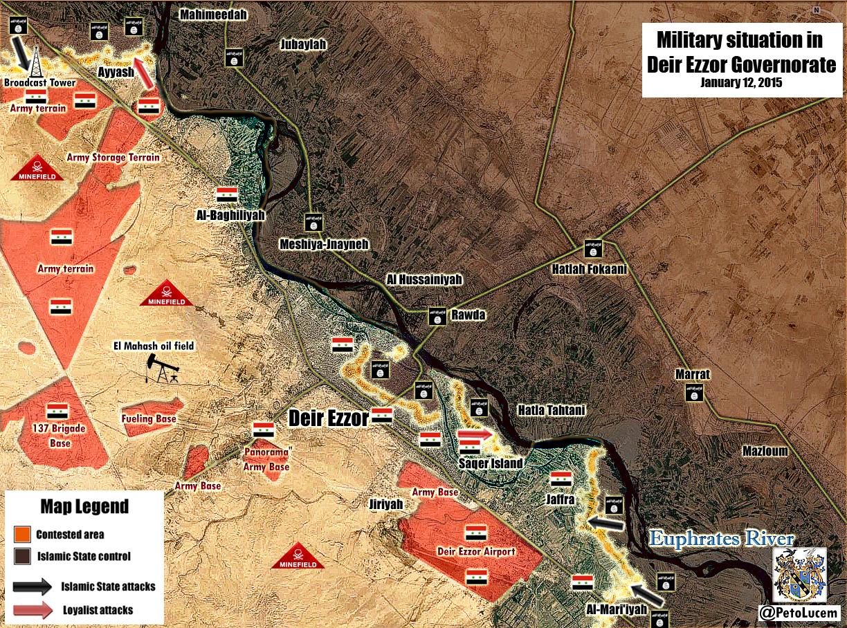
How should we deal with that [5] ? Those places, al-Jnayneh and al-Hsan, are located on the detailed Deir Er zoor map. Could somebody spot them exactly? Could they be Мешия-Джнейне and Al-Hussainiyah Paolowalter (talk) 18:21, 11 January 2015 (UTC)
- PaolowalterOn this occasion, you can turn to this editor MrPenguin20 In this discussion Deir ez-Zor clashes Hanibal911 (talk) 20:24, 11 January 2015 (UTC)
Khirbet al Atrah
This location was recently added to the map as an SAA-held town SW of Nubl/Zahraa, but looking on wikimapia it doesn't exist. The area labelled as it is literally a barren patch of ground [6]. I propose we remove it. Nhauer (talk) 20:52, 12 January 2015 (UTC)
I guess it´s valued as a strategic hill and there for marked. (Like the strategic hill Tall Shair next to the west of Kobane) Rhocagil (talk) 21:22, 12 January 2015 (UTC)
It was not added: it has always been there as a green dot. I changed it to red based on some maps I listed in the edit summary retaining the coordinates. Now I found a little better coordinate on wikimapia and I'll change them. Paolowalter (talk) 21:48, 12 January 2015 (UTC)
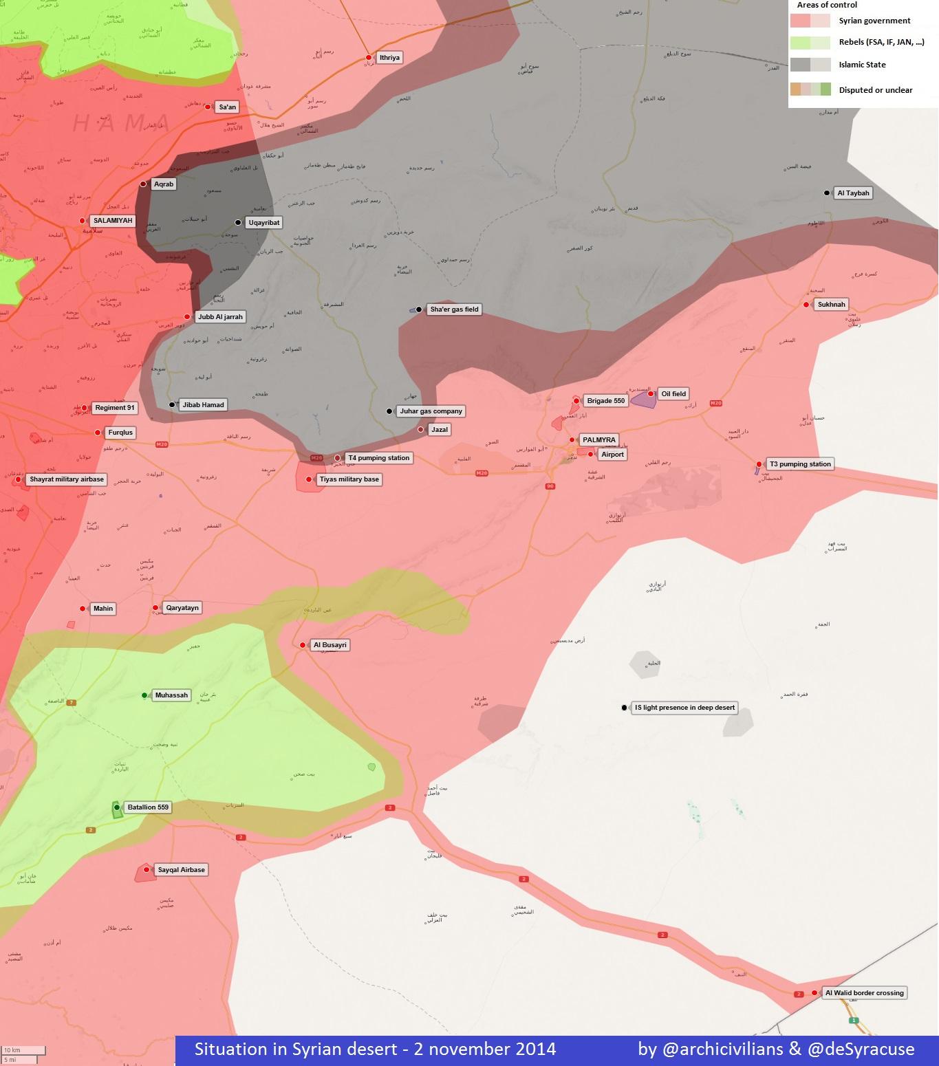
El Mahash oil field
Hey guys how you think we can add on the map El Mahash oil field which locatedto east from the army base 137th Armoured Brigade map in area which under control by army using pro-government map here Hanibal911 (talk) 12:46, 13 January 2015 (UTC)
Agree.We should also add the bordast tower to which is contested. Lindi29 (talk) 12:50, 13 January 2015 (UTC)
Hasakah
There are some inconsistencies on the map next to Hasakah. The town Tall Majdan was added just outside the detailed map with coordinates 36.533,40.6. But Tall Majdan appears also on the on the detailed map. From Wikimapia the right coordinates are [7]. After correction, the dot ends up on the detiled map (as you can see now) in a black (ISIS controlled) area. Logically it should be removed. On the same basis the village Rafrar, taken by SAA following http://www.agathocledesyracuse.com/archives/236 and https://twitter.com/IvanSidorenko1/status/554776902876299264 it is located [8] in a red area on the controlled map. Should the Tall Majdan black dot removed?Paolowalter (talk) 19:02, 13 January 2015 (UTC)
Tall Salmu
On our map a village Tall Salmu noted as under control by moderate rebels. But biased pro opposition source reported that today this village was captured of Al Nusra.here So either this village was contested between the army and Al Nusra then we must noted this village as contested between army and Al Nusra or if the Al Nusra took it from moderate insurgents we need marked him as under control by Al Nusra. But more likely it is that the village should be noted as contested between the Syrian troops and Al Nusra. Because source said that this village it is the gate of Abu ad-Duhur Military Airbase. So I ask of other editors express their opinions. Hanibal911 (talk) 21:15, 13 January 2015 (UTC) Judging from the source it seems that the claim is that JAN took it from SAA. The source is strongly pro-opp biased and therefore it cannot be used to register opposition advance. Just let's look for additional info fro other sources.Paolowalter (talk) 21:25, 13 January 2015 (UTC)
Yea i saw that tweet too but the actual first reports were published few days ago on opposition channels, i have read some on facebook (Idlib news channel etc). All of them said that Rebels (not mentioning any group) "have put Tall Salmu under their control". Before this, i know that government forces managed to break some rebel lines to the north of the airport (last year) and that Tall Salmu (what is actually a hill and not really a village) came under heavy SAF attack, dozens of rebel casulties.
- So I belive now they just reappeared on this strategic hill. Nothing should be changed. DuckZz (talk) 23:47, 13 January 2015 (UTC)
- Tall Salmu it is not hill it is a village. And if pro opposition source said that Al Nusra captured this village it means that previously it village was not under their control so we need data from a reliable source who can confirm that the village would really captured or we have to mark it as contested or controlled by Al Nusra. Because pro opposition source said that Al Nusra captured this village but not moderate rebels. Hanibal911 (talk) 09:25, 14 January 2015 (UTC)
- Personally, my opinion we should note this village under the control of Al Nusra. Hanibal911 (talk) 09:28, 14 January 2015 (UTC)
- Tall Salmu it is not hill it is a village. And if pro opposition source said that Al Nusra captured this village it means that previously it village was not under their control so we need data from a reliable source who can confirm that the village would really captured or we have to mark it as contested or controlled by Al Nusra. Because pro opposition source said that Al Nusra captured this village but not moderate rebels. Hanibal911 (talk) 09:25, 14 January 2015 (UTC)
- So I belive now they just reappeared on this strategic hill. Nothing should be changed. DuckZz (talk) 23:47, 13 January 2015 (UTC)
I think that Tell means hill and Tall describes a higher ground with something on it, not sure but nevermind, i know it's a village but located on high ground (where everything else around Abu Duhur is flat) thats why it's important.
- Previously JAN came from Idlib (After Marat Numan offensive) to Abu Duhur town and now they are on Tall Salmu, probably preparing for the next assault while rebels are around the airport aswell waiting. I don't see the logic puting this place under JAN control as we already said that their presence outside Idlib province is negligible and only present on frontlines (for example Alepo). If the airport falls, JAN will pull back to Idlib or go somewere else wherever their are needed.
- You can change Tall Salmu to grey as long as the airport stays in government hands . DuckZz (talk) 15:33, 14 January 2015 (UTC)
- Tell does not always mean that this is hill. Here is look on map it is not hill it is a village.Tall Salmu al-Shamali Hanibal911 (talk) 17:08, 14 January 2015 (UTC)
- JAN is not "negligible and only present on front lines" as the above poster DuckZz claims. See the new neutral Al-Monitor report on rising role of JAN around Aleppo and its countryside. Also the tense truce that JAN has with others in the area. I would suggest, like others have on multiple occasions, putting many of the greens in Idlib and Aleppo countryside to Green with a Grey circle inside. This shows a truce between these groups as working together in the area. Similar to the yellow-red truce in the north-east of the country. It is important because it shows the JAN has really become a separate group across this zone. See here: http://www.al-monitor.com/pulse/originals/2015/01/syria-nusra-fighters-no-alternatives.html
It states referring to Aleppo, the Aleppo countryside and the road leading from TUrksih border/Azaz to Aleppo: "Jabhat al-Nusra is stronger in some areas of the city than others, and has set up more checkpoints on the road from the Turkish border since Al-Monitor’s last visit in late October. The area is nevertheless still mostly under the control of the more moderate Jabhat Shamiya, a group recently formed on the basis of the Islamic Front that fights alongside Jabhat al-Nusra on several fronts but is not officially aligned with it." — Preceding unsigned comment added by 169.231.158.99 (talk) 22:10, 14 January 2015 (UTC)
- Here pro opposition source said that Al Nusra released pictures for their fighters in the outskirts of Abu Ad Duhuhur Airbase after they took village TallSalmu.Archicivilians and that according to Activists: Rebels now controlling all the outskirts of Abu Ad Duhuhur Airbase after JAN took control of village Tall Salmu yesterday.Archicivilians So this is clearly confirm by the fact that the village was under the control of the army until it was captured by Al Nusra (13 January only according to data from pro opposition sources) and at the moment we have no evidence that the village was completely captured Al Nusra. So if we not have data from a reliable source which confirm that village was captured Al Nusra we need noted this village as contested between Syrian troops and Al Nusra. And it will be correct because we cant use data from a pro-opposition sources to display of Al Nusra success in the fight against the army. So I beg express their opinions other editors Paolowalter Lindi29 EkoGraf Alhanuty Boredwhytekid XJ-0461 v2 Daki122 DuckZz ChrissCh94 Hanibal911 (talk) 11:28, 15 January 2015 (UTC)
Hanibal991 I agree with you.We must not forget that these so called activists also reported the capture of Nubol(or to be exact half the city of Nubol) they also reported that the rebels captured Tel-Bazzaq(Qunetra) but it also turned out to be fake.To note also that Abo-al-Duhur airport is operational and that means that there must be a safe zone around the airport established by the Army.Daki122 (talk) 14:45, 15 January 2015 (UTC)
Hanibal911 The problem with you is that you obviously don't understand English really well, everything what you said in your post above is the same thing i said in my last post. The airport is besieged, Tall Salmu was not in rebel hands due to SAF heavy airstrikes on that location, and that lasted for few days, the situation changes every 5 days because rebels, or JAN in this case, are not able to stay on Tall Salmu for a long time beucase that place is a strategic location that overlooks the airport. The SAA knows that and bombs Tall Salmu on daily basic. Do you understand it now ? I don't care for the color, that's not what i wanted to discuss. DuckZz (talk) 14:56, 15 January 2015 (UTC)
I agree with Hanibal911 beacause JAN are going in a big offensive to capture not only the air base but nubl and al-zahraa.Daki122 Ofc this is a pro-opp source but we dont use them to show advances against the regime,we only agree on some that are really trustworthy,yes they said they captured nubl and al-zahraa but we first disscus it that is true and to verify if that true we rely on others reliable sources who are neutral.Regard Lindi29 (talk) 15:23, 15 January 2015 (UTC)
From [9] Tall Salmo is controlled by SAA; it must go red with gray ring on the south.87.5.44.175 (talk) 17:24, 15 January 2015 (UTC)
- DuckZz Firstly, I very well know English. Secondly, you many talk but you dont provide evidence of your words. At the moment, we have data from opposition sources which reported that this village under control of Al Nusra Archicivilians but we also have a data from a pro government source Al Masdar which reported that this village is still under control of army. So in this case, the best solution will be to noted the village as a contested between Syrian troops and Al Nusra. Hanibal911 (talk) 18:53, 15 January 2015 (UTC)
Al-Masdar is an unreliable source,and is a well known pro-regime source,also we can never use a regime source to show a regime advance in Tal Salmu,there is reports of Air raids in the area near by. http://syriahr.com/en/2015/01/the-government-warplanes-attack-several-regions-in-aleppo-and-idlib/ Alhanuty (talk) 22:54, 15 January 2015 (UTC)
- Alhanuty But we also can not use data from the opposition sources to show the success of the rebels and Al Nusra. But on our map this village was mistakenly marked as under control by moderate rebels although only a few days ago right away two opposition sources said that he was captured by Al Nusra only 13 January but also we have a data from pro government source which said that the city is still under the control of the army. Therefore, until we get confirmation from a reliable source that the village under the control of Al Nusra I noted it as contested between the army and Al Nusra. And SOHR just said that Syrian air force implemented the airstrikes on some areas in villages and towns in the countryside of Abu al- Dohur.SOHR But SOHR not confirmed that Al Nusra now control a village of Tall Salmu. So need more data. Hanibal911 (talk) 07:00, 16 January 2015 (UTC)
Al-Thayyem field
There is a report from IavnSidorenko than IS pulled back from Al-Thayyem field, that are under control of local figthers allied with SAA. Is it OK to turn it red?Paolowalter (talk) 07:52, 14 January 2015 (UTC)
I know IvanSidorenko supposed to be neutral source, but i sounds a little to good to be true (???). Since i don´t speak arabic I have no idea what the man in the clip says. Rhocagil (talk) 16:19, 14 January 2015 (UTC)
There are videos as well of the capture. here: https://www.youtube.com/watch?v=SlzfAwP-9WQ&feature=youtu.be and here:https://www.youtube.com/watch?v=JV4CXRqVohw&feature=youtu.bevideos — Preceding unsigned comment added by 192.173.4.182 (talk) 16:59, 14 January 2015 (UTC)
- As a native Arabic speaker I could easily translate it: he basically said that the tribal forces have captured the Thayyem oil field. But this is video evidence that cannot be used to make changes. I don't know about other sources, but many news outlets (mostly pro-regime) reported it. We should wait for a more neutral source to show up. I believe that ISIS has indeed retreated since this coincided with its retreat from a couple of neighborhoods a few days ago. But we should wait for more sources. ChrissCh94 (talk) 21:12, 14 January 2015 (UTC)
Al-Thayyem field should be made contested. — Preceding unsigned comment added by 169.231.158.99 (talk) 22:21, 14 January 2015 (UTC)
- ChrissCh94 thanks for the translation! Anyway it´s interesting and we should keep our eyes open for more sources. Rhocagil (talk) 22:38, 14 January 2015 (UTC)
Al-Masdar has also declared the field under tribal fighter control [most likely loyalists]. http://www.almasdarnews.com/article/deir-ezzor-complete-field-report-battle-zone/ XJ-0461 v2 (talk) 23:37, 14 January 2015 (UTC)
Confirmed by Elijah J Magnier https://twitter.com/EjmAlrai/status/555607509780946946/photo/1 Fab8405 (talk) 09:48, 15 January 2015 (UTC)
Deir er Zor
Deir Ezzor Province: Violent clashes are taking place between the regime forces and IS in the neighborhoods of al- Rashidiyyi and al- Jbeleh in the city of Deir Ezzor.here. Lindi29 (talk) 15:46, 14 January 2015 (UTC)
Possible Demise of Green Opposition by 2015.
With the current tide of events a complete disband of FSA remain a option on the table. What will be the way to handle this scenario? Change colors and battle map distribution?, maybe at the very end of this year, the map will show a divided Syria between ISIS and the Regime. More rummors comes from a massive FSA disband in the Southern Front, with many men joining ISIS in the East. The same in Qalamoun Region, meanwhile all Kurdish Positions look in harms way with ISIS closing in.200.48.214.19 (talk) 17:10, 14 January 2015 (UTC)
First: this is not a place for predictions.
Second: ISIS will never be able to overrun all Kurdish and Rebel positions in Northern Syria, they are already on defensive. SAA+NDF, while on offensive, are failing to actually deliver a crushing blow to the rebels, and are actually losing on some fronts. The opposition will not end in 2015. — Preceding unsigned comment added by 191.251.123.194 (talk) 22:39, 14 January 2015 (UTC)
- After looking the land grab ISIS made on FSA on the East, and comparing the 2013 map with the 2014 its clear that the war is close for over for the FSA. At least if the tide continous this way, ISIS could take on Afrin after beating the FSA on the East of Afrin, since i doubt any real ISIS breakthrough in Aleppo, Too many SAA, FSA formations deployed in Urban Area, a possible sweep through North Aleppo city remain an option for ISIS strategists. For the SAA most of their advances have stalled thats true, but they continue having more or the same terrain from mid 2014, while the FSA its being eaten from inside by Hardcore Islamist, dont forget massive deflections to ISIS and JAN. Cheers for your lost cause 191.251.123.194.! 200.48.214.19 (talk) 22:58, 14 January 2015 (UTC)
In 2010, the entire map was red. Now, not even half the map is red. Using your logic, we should discuss possible scenarios for the complete downfall of the regime :) — Preceding unsigned comment added by 80.184.91.68 (talk) 02:24, 15 January 2015 (UTC)
The uprising begun on 2011, in 2010 there where no armed opposition, ISIS, JAN. If we use YOUR logic the map will have noting to do with the conflict. A all red map would be the political map of Syria before the conflict200.48.214.19 (talk) 13:14, 16 January 2015 (UTC)
Jabal al-Zawiya
Clashes between Al Nusra and SRF in Jabal al-Zawiya.Elijah J. Magnier Hanibal911 (talk) 17:12, 14 January 2015 (UTC)
SOHR reports the same, the say "wanted people" what could refer to ex-SRF members. DuckZz (talk) 17:40, 14 January 2015 (UTC)
contradiction in map
Why in the north-east of the country where YPG and SAA/NDF have truce to hold towns is it painted Yellow-Red, but around Aleppo and Idlib where both JAN and non-JAN rebels have truce to hold towns, these towns are not painted Green-Grey. They are painted only Green. This is a major problem with the map. It still acts as if JAN is in a united rebellion with these groups. They do have a truce and common enemy and are working together, but more and more we see JAN is its own group that is very dangerous to the rebellion and the people of Syria. Where JAN is not located the towns should be pure green. But where they are located it should be Grey-Green to show a truce, were rebel groups have sold out revolutions spirit to work with extreme fanatics. Khan Shaykun (in Idlib province) is one of the few places on map where this has been successfully done. That example should be in many other areas. — Preceding unsigned comment added by 169.231.158.99 (talk) 22:13, 14 January 2015 (UTC)
Also a small green dot should be added to Kobane- to show rebel FSA presence in Kobane to support YPG. — Preceding unsigned comment added by 169.231.158.99 (talk) 22:15, 14 January 2015 (UTC)
Nice try, i see the propagadna is working really well on both sides. You act like you came here and saw this map 2 days ago but we know that is not the case. Every month or so the same editor (probably you) suggest the same idea over and over again just to ruin the map and make it more complicated to edit. Jabhat Al Nusra fighters are present in 60% of the areas under anti-government control. Same goes for the Islamic front, FSA and other rebel groups. Applying this rule will mean to change the entire map completely. DuckZz (talk) 23:59, 14 January 2015 (UTC)
No, I am not an editor, just someone following events and chiming in here in the comments. and, Yes, I believe the map should be changed completely to reflect the situation more accurately- it should reflect a truce between blocs of groups that are very different ideologically, very different in who arms them, very different in goals, different tactics. Look at the towns of Nubl and Zahraa under siege. The circle around them is green. If you are a random viewer you would think, oh so the islamic front and fsa are sieging them.. but , reality check, those sieges are almost completely launched by JAN. Also you did not respond to my initial question: Why in the north-east of the country where YPG and SAA/NDF have truce to hold towns is it painted Yellow-Red, but around Aleppo and Idlib where both JAN and non-JAN rebels have truce to hold towns, these towns are not painted Green-Grey? This is a major contradiction of this map- that becomes more and more crystalized as time passes and JAN splits from the rebel groups that still are seen as palatable by certain state actors. Green should be for rebel groups that have not seized huge parts of rebel areas to run as their own caliphate and have not been blacklisted from working with all state actors. Grey , for JAN and its allies, represents a group that sometimes works with other more "palatable" groups but is obviously embarking on a much more extreme path.— Preceding unsigned comment added by 169.231.24.193 (talk) 08:15, 15 January 2015 (UTC)
Green-Grey needs to be debated here, for accuracy
Can anyone explain why khan shaykhun is the only city on the entire map that has a green dot with a grey circle within it? THis indicates a peaceful coexistence between JAN & allies (backed by no foreign states) with FSA&islamist forces that are openly backed by foreign states. That grey/green truce should be in many,many more towns that are now only showed as green. Its more and more clear that JAN should not fall under green. They are backed by no foreign states, they are the only rebel group to create their own break away caliphate, they do have truce and cooperation but they are also clearly on a very different path than the other "more palatable" rebel groups. They are launching their own raids into Lebanon. For this map to be accurate,which i think everyone wants, this needs to be seriously debated here.
My suggestion is to start gathering an evidence supported list of all locations where JAN is heavily present in rebel areas and then include within all these green dots a grey circle. — Preceding unsigned comment added by 169.231.24.193 (talk) 08:29, 15 January 2015 (UTC)
I guess you are kidding, JAN was made by qatari/saudi warmongers and sent to Syrian in 2012 by IS.
ok, so maybe they were, but I think its pretty clear that the NATO $ today is not going to them, its going to these more "palatable" groups and this is another source of the divisions between them. — Preceding unsigned comment added by 169.231.25.115 (talk) 18:11, 15 January 2015 (UTC)
Al Waer
Apparetnly in Al Waer a truce was estblished few days ago [10]. It should be marked so on the map.Paolowalter (talk) 10:23, 15 January 2015 (UTC)ú
It is a 24 hour ceasefire, in this time they will go to the table and hopefully agree on everything.
- Syrian rebels and government reach a truce in besieged area. But so far only to the ten days.The Daily Star Hanibal911 (talk) 19:34, 15 January 2015 (UTC)
confirms a truce process non a simple ceasefire. We put it on truce and wait for further news.Paolowalter (talk) 07:28, 16 January 2015 (UTC)
Tall Malid
Any source showing this village under rebel control ? A friend from Alepo said that ISIS bombs them in Mare' from this high ground village. DuckZz (talk) 15:00, 15 January 2015 (UTC)
- DuckZz I only found report from the pro government source of 20 December in which states that "Coalition Jets" hits Islamic Front in Tall Malid in northern Aleppo countryside.here Hanibal911 (talk) 19:16, 15 January 2015 (UTC)
Idlib
I haven't seen this map in two weeks, and when I looked today I was rather surprised to see the addition of six red towns north of Idlib city (these are: Kafr Jalis, Ad Duwayr, one without a name, Ayn Shib, An Ghafer and Tan 'Isa). I've checked this talk-page, but there has been no mention of a government offensive on this area. I've checked the news ... no mention of any SAA offensive in this area. Recently, Idlib city was raided by Islamist rebels, coming from surrounding towns. And now, all of the sudden, those towns are marked as SAA held? Without a source? Every map you check - even SyrianPerspective - shows those area's as rebel controlled (some FSA, some Jabhat al-Nusra). So, why are those six towns suddenly red or contested? — Preceding unsigned comment added by 84.24.43.183 (talk) 09:27, 16 January 2015 (UTC)
- Are you one of those anonymous editors who constantly criticize the changes made in favor of the Syrian army. Although you are and some other anonymous editors like you can not provide any useful data for this map. About the situation in the Iblib province you are just duplicat data from report in the pro opposition source.Archicivilians Nevertheless, as I wrote earlier I think that the village An Ghafer more likely under control of moderate rebels. Hanibal911 (talk) 12:44, 16 January 2015 (UTC)
Well then change Al Ghafer, because we already had a section on this talk page where you suggested that Al Ghafer should be changed, and nobody complained. DuckZz (talk) 15:49, 16 January 2015 (UTC)
Just keep an eye on it as pro gov sources report attacks on Kafr Takharim and Almanaz north of Al Ghafer .Pyphon (talk) 10:10, 17 January 2015 (UTC)pyphon
Talbiseh (again)
From [11] and [12] fighting in Talbiseh, Al-Mashrafeh, Al-Madrajeh, Al-Ghajjar, Al-Farhaaniyyeh, Al-Sina’ayyeh, Gharnaata, ‘Ayn Hussein Al-Jnoubi and Al-Zafrana. Some updatng of the map is necessary.79.10.133.67 (talk) 17:56, 16 January 2015 (UTC)