
Bransfield Basin: Difference between revisions
No edit summary |
No edit summary |
||
| Line 40: | Line 40: | ||
==Tectonic Development== |
==Tectonic Development== |
||
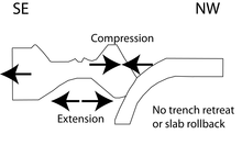
[[File:Bransfield Basin cartoon.tif|thumbnail|left|Schematic cartoon of the Bransfield Basin tectonic setting.]] |
[[File:Bransfield Basin cartoon.tif|thumbnail|left|Schematic cartoon of the Bransfield Basin tectonic setting.]] |
||
The Bransfield Basin is considered to be a [[back-arc basin]] that is located behind the South Shetland Islands. The Islands are believed to have formed from a [[subduction]] event that occurred between the [[Phoenix Plate]] and the [[Antarctic plate]] roughly 200 million years ago during the [[Mesozoic]].<ref name=Lawver>{{cite book|last1=Lawver|first1=Lawrence|last2=Keller|first2=Randall|last3=Fisk|first3=Martin|last4=Strelin|first4=Jorge|title=Backarc Basins: Tectonics and Magmatism|date=1995|publisher=Plenum Press|location=New York|pages=316-342}}</ref> |
|||
<ref name=Galindo-Zaldivar>{{cite book|last1=Galindo-Zaldivar|first1=Jesus|last2=Gamboa|first2=Luiz|last3=Maldonado|first3=Andres|last4=Nakao|first4=Seizo|last5=Bochu|first5=Yao|title=Antarctica: Contributions to global earth sciences|date=2006|publisher=Spring-verlag|location=New York|pages=243-248}}</ref><ref name="Eulalia Gracia">{{cite journal|last1=Gracia|first1=Eulalia|last2=Canals|first2=Miquel|last3=Farran|first3=Marcel|last4=Prieto|first4=Maria|last5=Sorribas|first5=Jordi|last6=Team|first6=Gebra|title=Morphostructure and Evolutionn of the Central and Eastern Bransfield Basins (NW Antarctic Peninsula|journal=Marine Geophysical Researches|date=1995|volume=18|pages=429-448}}</ref> |
|||
Revision as of 22:10, 21 February 2015
| Bransfield Basin | |
|---|---|
 This map of Antarctica and the bottom portion of South America shows the locations of Bransfield Strait, Drake Passage, and Scotia Arc. | |
| Type | Back-arc basin |
| Location | |
| Region | Northwest of the Antarctic Peninsula |
| Type section | |
| Country | Antarctica |
The Bransfield Basin is a Back-arc rift basin located off the Northern tip of the Antarctic Peninsula. The basin lies within a Northeast and Southwest trending strait that separates the peninsula from the nearby South Shetland Islands to the Northwest.[García 1]The basin extends for more than 500 kilometers from Smith Island to a portion of the Hero Fracture Zone.[1] The basin can be subdivided into three basins: Western, Central, and Eastern.[2] The Western basin is 130 kilometers long by 70 kilometers wide with a depth of 1.3 kilometers, the Central basin is 230 kilometers long by 60 kilometers wide with a depth of 1.9 kilometers, and the Eastern basin is 150 kilometers long by 40 kilometers wide with a depth of over 2.7 kilometers.[2]
Tectonic Development
The Bransfield Basin is considered to be a back-arc basin that is located behind the South Shetland Islands. The Islands are believed to have formed from a subduction event that occurred between the Phoenix Plate and the Antarctic plate roughly 200 million years ago during the Mesozoic.[3] [4][5]
Geology

Natural Resources
See Also
References
- ^ González-Casado, José; Jorge, Giner-Robles; Jerónimo, López-Martínez (November 2000). "Bransfield Basin, Antarctic Peninsula: Not a normal backarc basin". Geology. 28 (11): 1043–1046.
- ^ a b Schreider, Al.; Schreider, A.; Evsenko, E. (2014). "The Stages of the Development of the Basin of the Bransfield Strait". Oceanology. 54 (3): 365–373.
- ^ Lawver, Lawrence; Keller, Randall; Fisk, Martin; Strelin, Jorge (1995). Backarc Basins: Tectonics and Magmatism. New York: Plenum Press. pp. 316–342.
- ^ Galindo-Zaldivar, Jesus; Gamboa, Luiz; Maldonado, Andres; Nakao, Seizo; Bochu, Yao (2006). Antarctica: Contributions to global earth sciences. New York: Spring-verlag. pp. 243–248.
- ^ Gracia, Eulalia; Canals, Miquel; Farran, Marcel; Prieto, Maria; Sorribas, Jordi; Team, Gebra (1995). "Morphostructure and Evolutionn of the Central and Eastern Bransfield Basins (NW Antarctic Peninsula". Marine Geophysical Researches. 18: 429–448.
Cite error: There are <ref group=García> tags on this page, but the references will not show without a {{reflist|group=García}} template (see the help page).