
Bransfield Basin: Difference between revisions
No edit summary |
No edit summary |
||
| Line 47: | Line 47: | ||
==Geology== |
==Geology== |
||
[[File:Bransfield Basin cross section.tif|thumbnail|right|Cross section of the Bransfield Basin during alternating phases of glaciation]] |
[[File:Bransfield Basin cross section.tif|thumbnail|right|Cross section of the Bransfield Basin during alternating phases of glaciation]] |
||
The main factor that controls deposition inside the Bransfield basin is [[Glacial period|Glacial cyclicity]]. Additional contributing factors include [[Physical geography|Phyiography]], [[tectonics]], and [[oceanography]].<ref name=García group=García>{{cite journal|last1=García|first1=Marga|last2=Ercilla|first2=Gemma|last3=Alonso|first3=Belen|title=Morphology and sedimentary systems in the Central Bransfield Basin, Antarctic Peninsula: sedimentary dynamics fromshelf to basin|journal=Basin Research|date=2009|volume=21|pages=295-314}}</ref><ref name="Marga Garcia">{{cite journal|last1=Garcia|first1=Marga|last2=Ercilla|first2=Gemma|last3=Alonso|first3=Belen|last4=Casas|first4=David|last5=Dowdeswell|first5=Julian|title=Sediment lithofacies, processes and sedimentary models in the central Bransfield Basin, Antarctic Peninsula, since the Last Glacial Maximum|journal=Marine Geology|date=2011|pages=1-16}}</ref> |
The main factor that controls deposition inside the Bransfield basin is [[Glacial period|Glacial cyclicity]]. Additional contributing factors include [[Physical geography|Phyiography]], [[tectonics]], and [[oceanography]].<ref name=García group=García>{{cite journal|last1=García|first1=Marga|last2=Ercilla|first2=Gemma|last3=Alonso|first3=Belen|title=Morphology and sedimentary systems in the Central Bransfield Basin, Antarctic Peninsula: sedimentary dynamics fromshelf to basin|journal=Basin Research|date=2009|volume=21|pages=295-314}}</ref><ref name="Marga Garcia">{{cite journal|last1=Garcia|first1=Marga|last2=Ercilla|first2=Gemma|last3=Alonso|first3=Belen|last4=Casas|first4=David|last5=Dowdeswell|first5=Julian|title=Sediment lithofacies, processes and sedimentary models in the central Bransfield Basin, Antarctic Peninsula, since the Last Glacial Maximum|journal=Marine Geology|date=2011|pages=1-16}}</ref> Sedimentary systems occur on the margins that are related to glacial and glacialmarine, mass wasting, seabed fluid-escape, and countour current processes. Three[[Stratigraphy|Stratigraphic units]] have been identified on the margins. The oldest unit is an over- consolidated [[diamicton]] from subglacial processes. The middle unit is a pebbly-sandy stratified mud from the proximal-ice or sub-ice shelf. The youngest unit consists of diatmaceous mud originating from open marine conditions.<ref name="Marga Garcia" /> |
||
=== |
===Glacial processes=== |
||
===Glacialmarine processes=== |
|||
===Open Marine processes=== |
|||
==Magmatism== |
|||
==Natural Resources== |
|||
==See Also== |
==See Also== |
||
Revision as of 03:54, 22 February 2015
| Bransfield Basin | |
|---|---|
 This map of Antarctica and the bottom portion of South America shows the locations of Bransfield Strait, Drake Passage, and Scotia Arc. | |
| Type | Back-arc basin |
| Location | |
| Region | Northwest of the Antarctic Peninsula |
| Type section | |
| Country | Antarctica |
The Bransfield Basin is a Back-arc rift basin located off the Northern tip of the Antarctic Peninsula. The basin lies within a Northeast and Southwest trending strait that separates the peninsula from the nearby South Shetland Islands to the Northwest.[García 1]The basin extends for more than 500 kilometers from Smith Island to a portion of the Hero Fracture Zone.[1] The basin can be subdivided into three basins: Western, Central, and Eastern.[2] The Western basin is 130 kilometers long by 70 kilometers wide with a depth of 1.3 kilometers, the Central basin is 230 kilometers long by 60 kilometers wide with a depth of 1.9 kilometers, and the Eastern basin is 150 kilometers long by 40 kilometers wide with a depth of over 2.7 kilometers.[2]The three basins are separated by the Deception Island and Bridgeman Island.[García 1]
Tectonic Development
The Bransfield Basin is considered to be a back-arc basin that is located behind the South Shetland Islands. The Islands are believed to have formed from a subduction event that occurred between the Phoenix Plate and the Antarctic plate roughly 200 million years ago during the Mesozoic.[3] [4][5] It is believed that the Pheonix plate stopped subducting under the Antarctic plate at least 4 million years ago during the Pliocene.[2][3][4][5]. Once the subduction event ceased, it is believed that the extension that created the basin was initiated. Aeromagnetic surveys have provided evidence that the extension occurred 1.8 Million years ago during the Pleistocene at a rate of 0.25 to 0.75 cenimeters per year. [5]
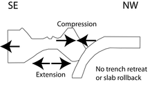
It is widely accepted that the Bransfield basin formed from extension caused by slab rollback.[2][3][4][5] New geophysical and structural data contradicts previously believed theories about slab rollback being the main mechanism for the opening of the basin.[García 1][1] A newer theory for the opening of the basin is attributed to sinistral strike-slip motion between the Scotia Plate and Antarctic plates.[1][6] It is theorized that the trench between the the Phoenix and Antarctic plates is locked in place and there is not any motion within the trench. The new data suggests trench retreat is not attributed as a mechanism for extension because there is a lack of seismic activity in the South Shetland Trench area, and that slab rollback is not a mechanism for extension too because if it were then Northwest-Southeast extension should be observed in the entire South Shetland region but instead compression can be observed.It is proposed that the motion between the Scotia plate and Antarctic plate are pushing the Phoenix plate to the Northwest creating compression.[1] [6]
Geology

The main factor that controls deposition inside the Bransfield basin is Glacial cyclicity. Additional contributing factors include Phyiography, tectonics, and oceanography.[García 1][7] Sedimentary systems occur on the margins that are related to glacial and glacialmarine, mass wasting, seabed fluid-escape, and countour current processes. ThreeStratigraphic units have been identified on the margins. The oldest unit is an over- consolidated diamicton from subglacial processes. The middle unit is a pebbly-sandy stratified mud from the proximal-ice or sub-ice shelf. The youngest unit consists of diatmaceous mud originating from open marine conditions.[7]
Glacial processes
Glacialmarine processes
Open Marine processes
Magmatism
See Also
References
- ^ a b c d González-Casado, José; Jorge, Giner-Robles; Jerónimo, López-Martínez (November 2000). "Bransfield Basin, Antarctic Peninsula: Not a normal backarc basin". Geology. 28 (11): 1043–1046.
- ^ a b c d Schreider, Al.; Schreider, A.; Evsenko, E. (2014). "The Stages of the Development of the Basin of the Bransfield Strait". Oceanology. 54 (3): 365–373.
- ^ a b c Lawver, Lawrence; Keller, Randall; Fisk, Martin; Strelin, Jorge (1995). Backarc Basins: Tectonics and Magmatism. New York: Plenum Press. pp. 316–342.
- ^ a b c Galindo-Zaldivar, Jesus; Gamboa, Luiz; Maldonado, Andres; Nakao, Seizo; Bochu, Yao (2006). Antarctica: Contributions to global earth sciences. New York: Spring-verlag. pp. 243–248.
- ^ a b c d Gracia, Eulalia; Canals, Miquel; Farran, Marcel; Prieto, Maria; Sorribas, Jordi; Team, Gebra (1995). "Morphostructure and Evolutionn of the Central and Eastern Bransfield Basins (NW Antarctic Peninsula". Marine Geophysical Researches. 18: 429–448.
- ^ a b Fretzdorff, Susanne; Worthington, Time; Haase, Karsten; Hekinian, Roger; Franz, Leander; Keller, Randall; Stoffers, Peter (2004). "Magmatism in the Bransfield Basin:Rifting of the South Shetland Arc?". Journal of Geophysical Research. 109: 1–19.
- ^ a b Garcia, Marga; Ercilla, Gemma; Alonso, Belen; Casas, David; Dowdeswell, Julian (2011). "Sediment lithofacies, processes and sedimentary models in the central Bransfield Basin, Antarctic Peninsula, since the Last Glacial Maximum". Marine Geology: 1–16.
Cite error: There are <ref group=García> tags on this page, but the references will not show without a {{reflist|group=García}} template (see the help page).